History of Dunedin
The city of Dunedin, New Zealand has played an important role in the history of New Zealand. Archaeological evidence points to the area having been long inhabited by Māori prior to the European arrival. It was a significant centre in the Archaic period when the North Island was scarcely inhabited. It was one of a few places of European sojourn and occupation in the Contact Period before 1840. It saw the establishment of perhaps the most utopian Wakefield settlement in 1848 by the Free Church of Scotland.
The discovery of gold inland from Dunedin in 1861 led to the new city becoming the colony's main industrial and commercial centre. The successful export of frozen meat provided an extra impetus to Dunedin's importance and growth, as did the establishment of the country's first university.
Pre-European history
Archaeological evidence shows the first human (Māori) occupation of New Zealand occurred around AD 1250–1300,[1] with population concentrated along the south east coast. A camp site at Kaikai's Beach, near Otago Heads, has been dated about that time. From this Moa Hunter (Archaic) phase of Māori culture there are numerous sites in the Dunedin area, including ones interpreted as permanent villages at Little Papanui and Harwood Township in the 14th century. With reduced moa numbers the population slumped but grew again with the evolution of a new Classic culture producing fortified villages (pa), the one at Pukekura (Taiaroa Head) being established about 1650.
In this period there were Māori settlements in what is now central Dunedin (Otepoti), above Anderson's Bay (Puketai), on Te Rauone Beach (Te Ruatitiko and Tahakopa), around Otago Harbour. There were also settlements at Whareakeake (Murdering Beach), Pūrākaunui, Mapoutahi (Goat Island Peninsula) and Huriawa (Karitane Peninsula) to the north, and at Taieri Mouth and Otokia (Henley) to the south, all inside the present boundaries of Dunedin.
Central Dunedin was still occupied about 1785 but was abandoned before 1826. Pūrākaunui and Mapoutahi were abandoned late in the 18th century and Whareakeake about 1825.
Māori tradition speaks of Rakaihautu excavating Kaikorai Valley in ancient time, of Kahui Tipua and Te Rapuwai, ancient peoples of shadowy memory, and then Waitaha, followed by Kati Mamoe, the latter arriving late in the 16th century, and then Kai Tahu ('Ngai Tahu' in modern standard Māori) from about the middle of the 17th century. European accounts of these arrivals have often represented them as invasions. Modern scholarship has cast doubt on that and they are probably really migrations, incidentally attended by bloodshed, like the later European arrival.Personalities from this time and later, such as Taoka and Te Wera, Tarewai and Te Rakiihia are identified with events at Huriawa, Mapoutahi, Pukekura and Otepoti and have descendants known in the historical period. Te Rakiihia died and was buried somewhere in what is now central Dunedin about 1785.
The sealer John Boultbee recorded in the 1820s that the 'Kaika Otargo' (settlements around and near Otago Harbour) were the oldest and largest in the south.
The arrival of the Europeans
Captain James Cook stood off at what is now the coast of Dunedin between February 25 and March 5, 1770 and named Cape Saunders on the Otago Peninsula and Saddle Hill. He charted the area and reported penguins and seals in the vicinity which led sealers to visit, their first recorded landings being late in the first decade of the 19th century. A feud between sealers and Māori, sparked by an incident on a ship in Otago Harbour in 1810, continued until 1823. With peace re-established Otago Harbour went from being a secret sealers' haven to an international whaling port.
Before the Scottish settlement William Tucker settled at Whareakeake (Murdering Beach) near Otago Heads in 1815. The Weller brothers, Joseph, George and Edward, established their whaling station at Wellers Rock, at what is now called Otakou on the Otago Harbour, in 1831. Long, Wright & Richards started a whaling station at Karitane in 1837 and Johnny Jones sent pioneers to settle land at Waikouaiti in 1840, all inside the territory of the modern City of Dunedin. The settlements at Wellers Rock, Karitane and Waikouaiti have endured making modern Dunedin one of the longest European settled territories in New Zealand.
Scottish settlement diluted
The Lay Association of the Free Church of Scotland, through a company called the Otago Association, founded Dunedin at the head of Otago Harbour in 1848 as the principal town of its Scottish settlement. The name comes from Dùn Èideann, the Scottish Gaelic name for Edinburgh, the Scottish capital. Charles Kettle the city's surveyor, instructed to emulate the characteristics of Edinburgh, produced a striking, 'Romantic' design. The result was both grand and quirky streets as the builders struggled and sometimes failed to construct his bold vision across the challenging landscape. Captain William Cargill, a veteran of the war against Napoleon, was the secular leader. The Reverend Thomas Burns, a nephew of the poet Robbie Burns, was the spiritual guide.
In 1852 when the provinces were created Dunedin became the capital of the Otago Province, the whole of New Zealand from the Waitaki south. It was the only one of New Zealand's original six provinces to have a Māori name - a reflection of the area's European settlement in pre-colonial times. There were squabbles between 'the Old Identity' - the Scottish, Presbyterian majority, and 'the Little Enemy' - the English, Anglican minority. Dunedin developed a reputation for furious public debate which continues to the present in the letters columns of the local newspapers.
In 1861 the discovery of gold at Gabriel's Gully led to a rapid influx of population and saw Dunedin become New Zealand's first city by growth of population in 1865. The new arrivals included many Irish, but also Italians, French, Germans, Jews and Chinese, all lumped together by the earlier settlers as 'the New Iniquity'. The Catholic church established a strong presence and also the Jewish population established a synagogue. Some people made fortunes and built grand houses. Slums developed in the inner city. Dunedin and the region industrialised. Dunedin's first railway, the Port Chalmers Branch, was opened on 1 January 1873 and was the first railway built to the newly adopted (3 ft 6 in (1,067 mm)) narrow gauge to open in New Zealand. The Main South Line, linking Dunedin with Christchurch and Invercargill, was opened on 22 January 1879. After ten years of gold rushes the economy slowed but Julius Vogel's immigration and development scheme brought thousands more especially to Dunedin and Otago before recession set in during the 1880s.
The development of modern Dunedin
In this first time of prosperity many institutions and businesses were established in Dunedin, New Zealand's first daily newspaper, its first university, art school and medical school among them. A combination of money, good building stones and the then Scottish international pre-eminence in architecture saw a remarkable flowering of substantial and ornamental buildings, unusual for such a young and distant colony. R.A. Lawson's First Church of Otago and Knox Church are notable examples. Maxwell Bury's clock tower complex for the University (University of Otago Clocktower complex) and F.W. Petre's St Joseph's Roman Catholic Cathedral are others started in this time. The city's landscape and burgeoning townscape were vividly portrayed by George O'Brien.
Difficult economic conditions led to the 'anti-sweating' movement led by a Presbyterian Minister, Rutherford Waddell, and the Otago Daily Times (under the editorship of Sir George Fenwick). From it came the establishment of the New Zealand Labour Party. Early in the 1880s the inauguration of the frozen meat industry, with the first shipment leaving from Port Chalmers, saw the beginning of a later great national industry. In the mid-1890s the gold dredging boom began and by around the start of the 20th century Dunedin was experiencing another time of prosperity.
This was a fertile period in the visual arts. William Mathew Hodgkins, the 'father of art in New Zealand' - according to his daughter Frances Hodgkins - certainly presided over a vital scene. From the interlocking circles of Turneresque Romantic landscape painters and younger impressionistic practitioners, G.P. Nerli helped to launch Frances Hodgkins on her career as New Zealand's most distinguished expatriate artist.
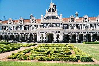
From the 1890s the Assyrians, religious refugees from what is now Lebanon, started to arrive, packing into the inner city slums largely occupied by Chinese. It was in this milieu John A. Lee grew up, the later Labour firebrand whose novels exposing these conditions would shock the country. But merchants like Edward Theomin built his grand town house Olveston and the Dunedin Railway Station was an opulent building, both completed in 1906. More companies and institutions were founded in these years, the Dunedin Public Art Gallery in 1884, the Otago Settlers Museum in 1898 and the Hocken Collections in 1910, all first of their types in New Zealand. But Dunedin was no longer the biggest city.

Determined to defeat demographic gravity Otago and Dunedin sent proportionately more personnel to the First World War than the other New Zealand districts and the losses were proportionately greater. The Anglican Cathedral, St. Paul's started in 1915 and consecrated in 1919 was the last great Gothic Revival building, and remains uncompleted. In another act of demographic defiance the 1925 New Zealand and South Seas Exhibition was staged at Logan Park to coincide with the five yearly census. 3.3 million people visited, more than attended any New Zealand exhibition before or since. The tramways' profits paid for a new town hall, still New Zealand's largest. But population growth continued to slow. With the 1930s the international depression set in. In early 1932 there were urban riots later repeated in the northern centres.
Despite the city's slow growth the university continued to expand boosted by its monopoly in health sciences. The developing Colleges and Halls saw the establishment of a student quarter. In this time too people started to notice Dunedin's mellowing, the ageing of its grand old buildings, with writers like E.H. McCormick pointing out its atmospheric charm. R.N. Field at the art school inspired young students to break from tradition with M.T. (Toss) Woollaston, Doris Lusk, Anne Hamblett, Colin McCahon and Patrick Hayman forming the first cell of indigenous Modernism. The Second World War saw the dispersal of these painters, but not before McCahon had met a very youthful poet, James K. Baxter, in a central city studio.
After the war prosperity and population growth revived, although Dunedin trailed as the fourth 'main centre'. A generation reacting against Victorianism started demolishing its buildings for redevelopment, which in Dunedin often meant open air car parks. Many buildings were lost, notably William Mason's Stock Exchange in 1969. The university expanded, the rest of the city did not. Between 1976 and 81 it went into absolute decline. This lent support to the proposal to establish an aluminium smelter at Aramoana as one of Sir Rob Muldoon's 'think big' projects.Its economics were doubtful and once exposed by Otago Professor, Paul Van Moeseke, the government backed off. But the city became bitterly divided.
This was a culturally vibrant time with the university's new privately endowed fellowships for writers, composers and visual artists, bringing such luminaries as James K Baxter, Ralph Hotere, Janet Frame, Hone Tuwhare, back to the city, or to Dunedin for the first time, where some stayed and many lingered. Good Modernist buildings appeared, such as the Dental School and Ted McCoy's Otago Boys' High School and Richardson building, evidence that this born-in-Dunedin designer could find a way of marrying Modernism to the revivalist inheritance.
In the 1980s, these trends were paralleled by a burgeoning popular music scene which made Dunedin and its "Dunedin Sound" well-known to rock music fans. Local bands such as The Chills, Straitjacket Fits, The Clean, and The Verlaines became popular both nationwide and internationally.
Population decline steadied. By 1990 Dunedin had re-invented itself as the 'heritage city' with its main streets refurbished in Victorian style and R.A Lawson's Municipal Chambers in the Octagon handsomely restored. The university's growth accelerated. North Dunedin became New Zealand's largest and most exuberant residential campus. Local body reform saw the creation of the present huge territorial Dunedin, the country's largest city, in 1989, a distinction many found dubious.
The city has continued to refurbish itself, rehousing the Dunedin Public Art Gallery in the Octagon in 1996 and buying and restoring the Railway Station and now embarking on a large development of the Otago Settlers Museum. Dunedin continues to be preoccupied with its population and economic future but people have lived here for nine centuries through radically changing fortunes. Unlike other New Zealand cities something of that is reflected in its atmosphere with its constant recall of the past and promise of future surprises.
Historical notes
The University of Otago, the oldest university in New Zealand, was founded in Dunedin in 1869. Otago Girls' High School (1871) is said to be the oldest state secondary school for girls in the Southern Hemisphere. The first Catholic school was established in 1863. Dunedin became wealthy during the Central Otago goldrush which began at Gabriel's Gully near Lawrence in 1861. Between 1881 and 1957, Dunedin was home to the Dunedin cable trams, being both one of the first and last such systems operated anywhere in the world. During the 20th century, influence and activity moved north to the other centres ("the drift north").
References
- ↑ Irwin, Geoff; Walrond, Carl (2009-03-04). "When was New Zealand first settled? - The date debate". Te Ara Encyclopedia of New Zealand. Retrieved 2010-02-14.