Crescent City, California
| Crescent City, California | |
|---|---|
| City | |
|
Crescent City harbor | |
| Nickname(s): "The Redwood Gate to the Golden State" | |
 Crescent City, California Location in the state of California | |
| Coordinates: 41°45′21″N 124°12′06″W / 41.75583°N 124.20167°WCoordinates: 41°45′21″N 124°12′06″W / 41.75583°N 124.20167°W | |
| Country | United States |
| State | California |
| County | Del Norte |
| Incorporated | April 13, 1854[1] |
| Government | |
| • Mayor | Ron Gastineau[2] |
| • State senator | Mike McGuire (D)[3] |
| • Assemblymember | Jim Wood (D)[4] |
| • U. S. rep. | Jared Huffman (D)[5] |
| Area[6] | |
| • Total | 2.415 sq mi (6.255 km2) |
| • Land | 1.963 sq mi (5.085 km2) |
| • Water | 0.452 sq mi (1.170 km2) 18.7% |
| Elevation[7] | 43 ft (13 m) |
| Population (2010) | |
| • Total | 7,643 |
| • Estimate (2013)[8] | 7,188 |
| • Density | 3,200/sq mi (1,200/km2) |
| Time zone | Pacific (UTC-8) |
| • Summer (DST) | PDT (UTC-7) |
| ZIP codes | 95531, 95532, 95538 |
| Area code | 707 |
| FIPS code | 06-17022 |
| GNIS feature IDs | 277494, 2410262 |
| Website |
crescentcity |

Crescent City (Chetco-Tolowa: Taa-’at-dvn,[9] Yurok: Kohpey,[10] Wiyot: Daluwagh [11]) is the county seat and only incorporated city in Del Norte County, California. Named for the crescent-shaped stretch of sandy beach south of the city, Crescent City had a total population of 7,643 in the 2010 census, up from 4,006 in the 2000 census. The population includes inmates at Pelican Bay State Prison, also within the city limits, and the former census-designated place Crescent City North annexed to the city. The city is also the site of the Redwood National Park headquarters, as well as the historic Battery Point Light. Due to the richness of the local Pacific Ocean waters and the related catch, and ease of access, Crescent City Harbor serves as home port for numerous commercial fishing vessels.
The city is located on the Pacific coast in the upper northwestern part of California, about 20 miles (32 km) south of the Oregon border. Crescent City's offshore geography makes it unusually susceptible to tsunamis.[12] Much of the city was destroyed by four tsunami waves generated by the Good Friday earthquake off Anchorage, Alaska in 1964. More recently, the city's harbor suffered extensive damage and destruction due to tsunamis generated by the March 11, 2011 earthquake off Sendai, Japan. Several dozen vessels and many of the docks they were moored to were destroyed as wave cycles related to the tsunamis exceeded 8 feet (2.4 m). Its climate is also very moderate, with very cool summers for its latitude as a result of intense maritime moderation. Nearby inland areas behind the mountains have significantly warmer summers.
History
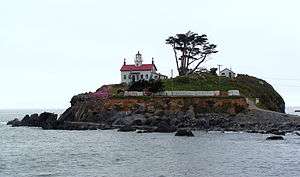
The area that is now known as Del Norte County[13] was and still is inhabited by the Yurok (Klamath River Indians) and Tolowa Nations of indigenous peoples. The first European American to explore this land was pioneer Jedediah Smith in the early 19th century. He was the first European American to reach the area overland on foot in a time before the European Americans knew anything about such a distant territory. For him it was literally "Land's End" — where the American continent ended at the Pacific Ocean. In 1855 Congress authorized the building of a lighthouse at "the battery point" (a high tide island on the coast of Crescent City) which is still functioning as a historical landmark.[14]
European explorers first visited the area now known as Crescent City by ship in the late-1820s.[15] Europeans began moving to the area in the 1850s. Crescent City was incorporated as a city in 1854.[16]
Historic ships
- Crescent City was the name of a 113-ton schooner built in 1848 by Joshua T. Foster of Medford, MA.[17]
- The Brother Jonathan a paddle steamer crashed on uncharted rock near Point St. George, off the coast of Crescent City, California, on 30 July 1865.[18]
- A 1906 ship named Crescent City was the former Jim Butler, a 701-ton steam schooner built by Lindstrom Shipbuilding Company in Aberdeen, Washington,[19] that wrecked in the Channel Islands, off Santa Cruz Island, in 1927.[20]
- The SS Emidio was a 6912-ton tanker of the General Petroleum Corporation (later Mobil Oil), which became the first casualty of the Imperial Japanese Navy's submarine force action on California's Pacific Coast. The abandoned tanker drifted north and broke up on the rocks off Crescent City. The remaining pieces of the ship are now California Historical Landmark #497.[21]
Geography
According to the United States Census Bureau, the city has a total area of 2.415 square miles (6.25 km2), of which 1.963 square miles (5.08 km2) (81.3%) is land and 0.452 square miles (1.17 km2) (18.7%) is water. Fishing and crabbing, tourism, and timber are the major sources of income in the city, as well as the County of Del Norte.[22] The mouth of Elk Creek, where it flows into the Pacific Ocean, is in Crescent City. Its nearest Californian place of any size to its interior is Happy Camp separated by roughly 42 miles (68 km) by air, but due to the unsuitable terrain its much farther away by road. The nearest city is fellow coastal city Brookings, around 20 miles (32 km) to its north. The Humboldt Bay area encompassing Eureka and Arcata is more than 60 miles (97 km) to its south. Crescent City is as far north in latitude as Chicago as well as New England on the Atlantic side and is as much as nine degrees latitude north of San Diego at the southern tip of the state.


Climate
Crescent City has a cool-summer mediterranean climate (Köppen Csb), with moderation similar to an oceanic climate. It is one of the wettest places in California: the annual rainfall is 71.24 inches or 1,810 millimetres. The wettest months are from October to March; the wettest month is December with 13.70 inches or 348.0 millimetres and the driest month is July with 0.35 inches or 8.9 millimetres. The average high and low temperatures in January are 54 °F or 12.2 °C and 41 °F or 5 °C. The average high and low temperatures in August are 66 °F or 18.9 °C and 51 °F or 11 °C. On average, fifteen mornings each winter fall below 32 °F or 0 °C.[23]
The highest temperature recorded in Crescent City was 93 °F (33.9 °C), observed on 24 September 1964, 1 June 1970, and 10 October 1991. The lowest temperature on record was 19 °F (−7 °C) on 21 December 1990. The maximum monthly precipitation was 31.25 inches (793.8 mm) in November 1973, whilst the wettest “rain year” has been from July 1937 to June 1938 when 107.74 inches (2,736.6 mm) fell, and the driest almost certainly that from July 1976 to June 1977 with less than 40 inches (1,016.0 mm) (some days being missing in March 1977). The maximum 24-hour precipitation was 7.73 inches (196.3 mm) on 9 January 1995. The highest snowfall recorded for any period in 24 hours was 6.0 inches (0.15 m) occurring on 6 January 1972.[24]
| Climate data for Crescent City, California (1981–2010 normals, extremes 1894–present) | |||||||||||||
|---|---|---|---|---|---|---|---|---|---|---|---|---|---|
| Month | Jan | Feb | Mar | Apr | May | Jun | Jul | Aug | Sep | Oct | Nov | Dec | Year |
| Record high °F (°C) | 75 (24) |
78 (26) |
88 (31) |
86 (30) |
89 (32) |
91 (33) |
96 (36) |
95 (35) |
97 (36) |
93 (34) |
80 (27) |
80 (27) |
97 (36) |
| Average high °F (°C) | 54.2 (12.3) |
55.1 (12.8) |
55.9 (13.3) |
57.6 (14.2) |
60.5 (15.8) |
62.9 (17.2) |
65.3 (18.5) |
65.7 (18.7) |
65.3 (18.5) |
62.0 (16.7) |
56.6 (13.7) |
53.7 (12.1) |
59.6 (15.3) |
| Daily mean °F (°C) | 46.9 (8.3) |
47.6 (8.7) |
48.4 (9.1) |
49.9 (9.9) |
52.8 (11.6) |
55.3 (12.9) |
57.8 (14.3) |
58.3 (14.6) |
56.9 (13.8) |
53.7 (12.1) |
49.3 (9.6) |
46.4 (8) |
51.9 (11.1) |
| Average low °F (°C) | 39.7 (4.3) |
40.0 (4.4) |
40.8 (4.9) |
42.2 (5.7) |
45.2 (7.3) |
47.8 (8.8) |
50.4 (10.2) |
50.9 (10.5) |
48.4 (9.1) |
45.3 (7.4) |
42.0 (5.6) |
39.0 (3.9) |
44.3 (6.8) |
| Record low °F (°C) | 19 (−7) |
23 (−5) |
27 (−3) |
29 (−2) |
30 (−1) |
32 (0) |
36 (2) |
34 (1) |
33 (1) |
29 (−2) |
23 (−5) |
19 (−7) |
19 (−7) |
| Average rainfall inches (mm) | 10.82 (274.8) |
8.92 (226.6) |
9.11 (231.4) |
6.34 (161) |
3.54 (89.9) |
2.01 (51.1) |
0.35 (8.9) |
0.57 (14.5) |
1.19 (30.2) |
4.51 (114.6) |
10.18 (258.6) |
13.70 (348) |
71.24 (1,809.5) |
| Average rainy days (≥ 0.01 inch) | 15.2 | 12.6 | 14.7 | 11.6 | 7.5 | 4.8 | 1.8 | 2.7 | 3.6 | 7.7 | 14.4 | 15.2 | 111.8 |
| Source: NOAA[25][26] | |||||||||||||
Tsunamis

The topography of the sea floor surrounding Crescent City has the effect of focusing tsunamis. According to researchers at Humboldt State University and the University of Southern California, the city experienced tsunami conditions 31 times between the years 1933 and 2008.[27] Although many of these incidents were barely perceptible, eleven events included wave measurements exceeding one meter, four events caused damage, and one event in particular is commonly cited as "the largest and most destructive recorded tsunami to ever strike the United States Pacific Coast."[28]
On 27 March 1964, the Good Friday earthquake off Anchorage, Alaska, set in motion local landslide tsunamis, as well as a trans-Pacific wave. The tsunami wave travel time to Crescent City was 4.1 hours after the earthquake, but it only produced localized flooding.[29] The second and third waves to hit Crescent City were both smaller than the first wave, but the fourth wave struck with a height of approximately 20 feet (6.1 m) after having drawn the harbor out nearly dry.[29] The next morning the damage was counted: 289 buildings and businesses had been destroyed; 1000 cars and 25 large fishing vessels crushed; 12 people were confirmed dead, over 100 were injured, and more were missing; 60 blocks had been inundated with 30 city blocks destroyed in total. Although most of the missing were later accounted for, not all were tracked down. Insurance adjusters estimated that the city received more damage from the tsunami on a block-by-block basis than did Anchorage from the initial earthquake.[30]
The tsunami raced down the U.S. West Coast with more deaths and destruction, but no location was hit as hard. Crescent City bore the brunt, due to its offshore geography, position relative to the earthquake’s strike-line, underwater contours such as the Cobb Seamount, and the position of rivers near the city.[31] Although houses, buildings, and infrastructure were later rebuilt, years passed before the city recovered from the devastation to lives, property, and its economy. Since the 1980s the breakwater has been protected from normal storm waves by hundreds of Dolos armor units, 38 ton concrete shapes.[32]
The city is deemed to be tsunami-ready today. Its preparedness was tested on 14 June 2005 when the 2005 Eureka earthquake measuring 7.2 on the moment magnitude scale hit 90 miles (140 km) offshore; much of the city (an estimated 6000 people)[33] was evacuated in a matter of 20 minutes when a tsunami warning was issued, and a 26 cm. tsunami wave hit the area.[34]
On 15 November 2006, a magnitude 8.3 earthquake struck off Simushir Island in the Kuril Islands in the western Pacific. A tsunami warning was issued but rescinded hours later. However, a surge from that quake did hit the harbor at Crescent City causing damage to three docks and several boats. Governor Arnold Schwarzenegger declared a county state of emergency. Upon that declaration, the area affected was eligible for federal emergency relief funding to repair the damage.[35][36]
| Wikinews has related news: Japanese tsunami impacts California coastal town |
Parts of the city were evacuated on 11 March 2011, after a 9.0 earthquake struck Japan.[37][38] Thirty-five boats were destroyed, and the harbor suffered major damage.[39][40] The reported peak surge was over 8 feet (2.4 m) by 9:50am.[41] Five were swept out to sea, and one person killed.[39][42][43]
Demographics
| Historical population | |||
|---|---|---|---|
| Census | Pop. | %± | |
| 1860 | 638 | — | |
| 1870 | 458 | −28.2% | |
| 1890 | 907 | — | |
| 1900 | 699 | −22.9% | |
| 1910 | 1,114 | 59.4% | |
| 1920 | 955 | −14.3% | |
| 1930 | 1,720 | 80.1% | |
| 1940 | 1,363 | −20.8% | |
| 1950 | 1,706 | 25.2% | |
| 1960 | 2,958 | 73.4% | |
| 1970 | 2,586 | −12.6% | |
| 1980 | 3,075 | 18.9% | |
| 1990 | 4,380 | 42.4% | |
| 2000 | 4,006 | −8.5% | |
| 2010 | 7,643 | 90.8% | |
| Est. 2015 | 6,774 | [44] | −11.4% |
2003
As of the 2003 Population Estimate from the Census Bureau, there were 7,319 people residing in the city. Census data from the year 2000 indicate that the population density was 2,252.2 people per square mile (868.9/km²). There were 1,754 housing units at an average density of 986.1 per square mile (380.5/km²). The racial makeup of the city was 78.3% White, 0.5% Black or African American, 6.1% Native American, 4.6% Asian, 0.1% Pacific Islander, 4.3% from other races, and 6.0% from two or more races. 11.0% of the population were Hispanic or Latino of any race.
There were 1,578 households out of which 35.6% had children under the age of 18 living with them, 33.4% were married couples living together, 20.5% had a female householder with no husband present, and 41.7% were non-families. 35.8% of all households were made up of individuals and 13.6% had someone living alone who was 65 years of age or older. The average household size was 2.40 and the average family size was 3.12.
In the city the population was spread out with 30.1% under the age of 18, 11.1% from 18 to 24, 26.7% from 25 to 44, 18.2% from 45 to 64, and 13.9% who were 65 years of age or older. The median age was 32 years. For every 100 females there were 85.9 males. For every 100 females age 18 and over, there were 82.4 males.
The median income for a household in the city was $20,133, and the median income for a family was $22,058. Males had a median income of $36,667 versus $19,922 for females. The per capita income for the city was $12,833. 34.6% of the population and 33.7% of families were below the poverty line. Out of the total population, 46.6% of those under the age of 18 and 4.8% of those 65 and older were living below the poverty line.
2010
The 2010 United States Census[46] reported that Crescent City had a population of 7,643. The population density was 3,164.9 people per square mile (1,222.0/km²). The racial makeup of Crescent City was 5,052 (66.1%) White, 910 (11.9%) African American, 370 (4.8%) Native American, 333 (4.4%) Asian, 7 (0.1%) Pacific Islander, 696 (9.1%) from other races, and 275 (3.6%) from two or more races. Hispanic or Latino of any race were 2,342 persons (30.6%).
The Census reported that 4,063 people (53.2% of the population) lived in households, 28 (0.4%) lived in non-institutionalized group quarters, and 3,552 (46.5%) were institutionalized. The very high institutionalized percentage is a result of the presence of Pelican Bay State Prison, which was annexed into the city limits in the 1990s.
There were 1,707 households, out of which 559 (32.7%) had children under the age of 18 living in them, 512 (30.0%) were opposite-sex married couples living together, 314 (18.4%) had a female householder with no husband present, 114 (6.7%) had a male householder with no wife present. There were 170 (10.0%) unmarried opposite-sex partnerships, and 7 (0.4%) same-sex married couples or partnerships. 614 households (36.0%) were made up of individuals and 229 (13.4%) had someone living alone who was 65 years of age or older. The average household size was 2.38. There were 940 families (55.1% of all households); the average family size was 3.13.
The population was spread out with 1,107 people (14.5%) under the age of 18, 934 people (12.2%) aged 18 to 24, 3,292 people (43.1%) aged 25 to 44, 1,725 people (22.6%) aged 45 to 64, and 585 people (7.7%) who were 65 years of age or older. The median age was 34.9 years. For every 100 females there were 250.1 males. For every 100 females age 18 and over, there were 298.5 males.
There were 1,906 housing units at an average density of 789.2 per square mile (304.7/km²), of which 532 (31.2%) were owner-occupied, and 1,175 (68.8%) were occupied by renters. The homeowner vacancy rate was 7.7%; the rental vacancy rate was 4.8%. 1,203 people (15.7% of the population) lived in owner-occupied housing units and 2,860 people (37.4%) lived in rental housing units.
Government
In the California State Legislature, Crescent City is in the 2nd Senate District, represented by Democrat Mike McGuire,[3] and the 2nd Assembly District, represented by Democrat Jim Wood.[4]
In the United States House of Representatives, Crescent City is in California's 2nd congressional district, represented by Democrat Jared Huffman.[5]
Education
The public schools of Crescent City are part of the Del Norte County Unified School District, which encompasses all of the public schools in Del Norte County. The following are schools within Crescent City or its immediate vicinity.
- Del Norte High School is the only public high school in Crescent City, located on the northern edge of town. It replaced the earlier high school that was more centrally located, and which remains today as a public-access gymnasium and county offices.
- The Bess Maxwell Elementary School is the older of two elementary schools in the northern part of town that are located near the high school. Bess Maxwell serves grades 1–5. In its earlier years, it was a K–6 school.
- The Castle Rock Charter School is a K–12 charter school that provides personalized education to students, and is the liaison school for parents who home school their children. Among other programs, it operates the Tah-Ah-Dun American Indian Magnet School to provide for the unique requirements of American Indian students that might be at risk of dropping out of school. (Tah-Ah-Dun is the Tolowa name for Crescent City, honoring the Tolowa village that once stood where Crescent City is today.) The school is accredited by the Western Association of Schools and Colleges.
- Crescent Elk Middle School is the oldest operating school site in town, centrally located in Crescent City. The site was originally a K–8 school, but slowly shed grade levels to other schools as it became a 4–6 school with a separate 7–8 program, then the 6–8 program that it is today.
- Mary Peacock Elementary School is the newer of two elementary schools that are located near the high school. The creation of Pelican Bay State Prison caused an increase in housing demand in the Crescent City area, and an increased school district population. This school was built as a result of that demand, but is not directly associated with the prison.
- Joe Hamilton Elementary School is a K–5 school located near Crescent Elk Middle School. It was founded as a K–3 school.
- Pine Grove Elementary School has been a K–6 school for many years. It serves the eastern part of Crescent City.
- Sunset High School is another Crescent City high school with its own child care center.[47]
Infrastructure
Transportation
Highway access is provided by U.S. Route 101 that runs directly through the city, connecting the Oregon Coast to the north and Eureka to the south. U.S. Route 199 begins just north of Crescent City and heads northeast to Grants Pass, Oregon. The junction of U.S. Routes 101 and 199 is one of only two junctions of two U.S. Routes in California, the other being the junction of U.S. Routes 6 and 395 in Bishop.
SkyWest Airlines formerly conducted passenger flights to and from Del Norte County Airport (also known as Jack McNamara Field) as United Express until April 7, 2015. The majority of flights connect to San Francisco International Airport.[48] PenAir has contracted to begin services to and from the airport with Saab 340 turboprop aircraft beginning September 15, 2015.[49]
Local public transit is provided by Redwood Coast Transit and by various taxi companies. Crescent City is also served by Amtrak Thruway Motorcoach, Curry Public Transit, and POINT.
The Crescent City Harbor serves as a commercial fishing port for salmon, shrimp, tuna, cod, and dungeness crab commercial fishing vessels. The Harbor is also home to multiple fishing and non-fishing related businesses and harbor governmental offices. The Crescent City Harbor also has several pleasure boat docks.
Arts and culture
Attractions

- In town
- Nearby
Annual events
- Fourth of July fireworks display - July
- Sea Cruise Car Show Weekend - Columbus Day Weekend - October
Notable people
- Eunice Bommelyn - tribal historian and the last living person to speak Tolowa as a native first language
- Loren Bommelyn - tradition bearer for the Tolowa tribe
- Donald H. Clausen - American politician
- James F. Curtis - commander of Camp Lincoln
- Louis DeMartin - Del Norte County pioneer
- David Owen Dryden - builder-architect in the craftsman style
- Cody Hoffman - football wide receiver, and multi-record holder, for the football team of Brigham Young University
- Derrick Jensen - author and environmentalist[50]
- Rick Keene - California politician
- Lee Kohse - artist
- Justin Miller - lawyer and a federal appellate judge
- Buck Pierce - professional football player, Canadian Football League
- Jacksen Pierce - author
- Fred Rinne - visual and performance artist
- Max Steineke - petroleum geologist
- Audrey Wagner - outfielder in the All-American Girls Professional Baseball League
- Wendell Wood – conservationist and environmentalist[51]
See also
-
 California portal
 - Achulet Massacre
- Fort Dick, California
- Lake Earl
- Yontoket Massacre
References
- ↑ "California Cities by Incorporation Date". California Association of Local Agency Formation Commissions. Archived from the original (Word) on November 3, 2014. Retrieved April 5, 2013.
- ↑ "City Council". Crescent City, California. Retrieved November 29, 2014.
- 1 2 "Senators". State of California. Retrieved April 1, 2013.
- 1 2 "Members Assembly". State of California. Retrieved April 1, 2013.
- 1 2 "California's 2nd Congressional District - Representatives & District Map". Civic Impulse, LLC. Retrieved April 1, 2013.
- ↑ "2010 Census U.S. Gazetteer Files – Places – California". United States Census Bureau.
- ↑ "Crescent City". Geographic Names Information System. United States Geological Survey.
- ↑ "Population Estimates". United States Census Bureau. Retrieved 2014-11-28.
- ↑ "Siletz Talking Dictionary". Retrieved 2012-06-04.
- ↑ "Yurok Dictionary: Kohpey". Retrieved 2012-07-07.
- ↑ "Language; Wiyot Tribe". Retrieved 2012-07-07.
- ↑ McKinley, Jesse (March 16, 2011). "Sleepy California Town, and a Tsunami Magnet". New York Times. Retrieved March 17, 2011.
Crescent City has long been known as one of the nation’s most susceptible spots when it comes to tsunamis, something that experts say is a result of a number of factors
- ↑ "History and Heritage of Del Norte County in Northern California". Explore Del Norte County. Crescent City/Del Norte County Visitors Bureau. 2013. Retrieved February 10, 2013.
- ↑ "Battery Point (Crescent City), CA". Lighthouses of the United States. Lighthouse Friends. 2013. Archived from the original on February 5, 2012. Retrieved February 10, 2013.
- ↑ "The Redwood Empire". Wandering Lizard. Cristalen. 2010. Retrieved February 10, 2013.
- ↑ "Crescent City People and Place" (PDF). Community Profiles. National Oceanic and Atmospheres Administration. 2007. Retrieved February 10, 2013.
- ↑ Gleason, Hall (1937). Old Ships and Ship-Building Days of Medford. Medford, MA: J.C. Miller. p. 71.
- ↑ Powers, Dennis (2006). Treasure Ship: The Legend and Legacy of the S.S. Brother Jonathan. New York, New York: Kensington/Citadel Press.
- ↑ Crescent City, Puget Sound Maritime Historical Society Images, University of Washington Libraries
- ↑ "Crescent City, CINMS Shipwreck Database". NOAA / National Marine Sanctuaries. Retrieved May 23, 2010.
- ↑ Webber, Ebbert "Bert" (1975). Retaliation: Japanese Attacks and Allied Countermeasures on the Pacific Coast in World War II. Oregon State University Press. ISBN 0-87071-076-1.
- ↑ Smith, Christopher (July 1, 2012). "Del Norte County piers". Los Angeles Times. Retrieved 23 May 2016.
- ↑ "Crescent City, California". Current and Historical Weather Conditions. Weatherbase. 2013. Retrieved February 11, 2013.
- ↑ "Crescent City 3 NNW, CA" (PDF). Climatography of the United States, Number 20,. U.S. Department of Commerce, National Ocean and Atmospheric Administration. Retrieved February 11, 2013.
- ↑ "NowData - NOAA Online Weather Data". National Oceanic and Atmospheric Administration. Retrieved July 30, 2016.
- ↑ "CA Crescent City 3 NNW". National Oceanic and Atmospheric Administration. Retrieved July 30, 2016.
- ↑ Dengler, Lori; B. Uslu; A. Barberopoulou; J. Borrero; C. Synolakis (September–October 2008). "The Vulnerability of Crescent City, California, to Tsunamis Generated by Earthquakes in the Kuril Islands Region of the Northwestern Pacific". Seismological Research Letters. 79 (5): 608–619. doi:10.1785/gssrl.79.5.608. Retrieved February 11, 2013.
- ↑ "1964 Alaskan Tsunami". USC Tsunami Research Group. University of Southern California. Retrieved February 11, 2013.
- 1 2 Pararas-Carayannis, George (2007). "The Effects of the March 27, 1964 Alaska Tsunami In California". The Tsunami Page. Retrieved February 11, 2013.
- ↑ Dennis M. Powers (January 1, 2005). The Raging Sea: The Powerful Account of the Worst Tsunami in U.S. History. Citadel Press. pp. 4–. ISBN 978-0-8065-2682-9.
- ↑ Silverman, Billy (March 14, 2011). "Crescent City Tsunami Is 34th Since 1934". Huffington Post Los Angeles. Retrieved October 4, 2013.
- ↑ https://icce-ojs-tamu.tdl.org/icce/index.php/icce/article/viewFile/5580/5253
- ↑ http://www.sfgate.com/news/article/7-0-quake-shakes-up-North-Coast-Crescent-City-2662395.php
- ↑ http://earthquake.usgs.gov/earthquakes/eqinthenews/2005/usziae/#summary
- ↑ Crescent City Suffers Damage from November 15, 2006 Kuril Island Earthquake and Tsunami, California Department of Transportation
- ↑ Uslu, B., Borrero, J., Dengler, L., Synolakis, C., and Barberopoulou, A., Tsunami Inundation from Great Earthquakes on the Cascadia Subduction Zone along the Northern California Coast, Solutions to Coastal Disasters 2008: pp. 204-214, doi: 10.1061/40978(313)19, American Society of Civil Engineers, ISBN (print): 978-0-7844-0978-7
- ↑ Tam, Donna, Tsunami takes toll on North Coast; hundreds evacuated, Gov. Brown declares state of emergency, Eureka Times-Standard, March 12, 2011
- ↑ Evert, Barry,Pelican Bay Sgt. describes response to Tsunami, March 11, 2011, accessed October 4, 2013
- 1 2 Johnson, C. (March 3, 2011). "Tsunami sweeps 5 to sea, rips out California docks". KXTV. Retrieved March 11, 2011.
- ↑ Waves destroy Crescent City Harbor docks, Eureka Times-Standard, March 11, 2011
- ↑ Great Japan quake generates 8-foot tsunami in California, Dr. Jeff Masters' WunderBlog, accessed October 4, 2013
- ↑ "Five swept out to sea, 1 killed as tsunami hits Crescent City, California". International Business Times. March 11, 2011.
- ↑ Anton, Mike; Li, Shan (March 11, 2011). "Crescent City harbor destroyed; 4 people swept into sea, 1 feared dead". Los Angeles Times.
- ↑ "Annual Estimates of the Resident Population for Incorporated Places: April 1, 2010 to July 1, 2015". Retrieved July 2, 2016.
- ↑ "Census of Population and Housing". Census.gov. Archived from the original on May 11, 2015. Retrieved June 4, 2015.
- ↑ "2010 Census Interactive Population Search: CA - Crescent City city". U.S. Census Bureau. Retrieved July 12, 2014.
- ↑ Sunset High School Infant-Toddler Center |Crescent City Child Care Center | ChildcareCenter.us
- ↑ "UNITED Ends San Francisco – Crescent City Service from April 2015". Retrieved December 17, 2014.
- ↑ http://flycrescentcity.com/airlines-and-flights/
- ↑ Jensen, Derrick (2006). Endgame, Volume 1: The Problem of Civilization. Seven Stories Press. p. 17. ISBN 1-58322-730-X.
- ↑ Richard, Terry (2015-08-14). "Wendell Wood, 65, remembered as protector of environment". The Oregonian. Retrieved 2015-09-03.
External links
| Wikinews has related news: |
- Official website
- Crescent City/Del Norte County Visitors Bureau Information Site
- Del Norte County Historical Society
| Wikimedia Commons has media related to Crescent City, California. |
Municipalities and communities of Del Norte County, California, United States | ||
|---|---|---|
| City | 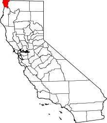 | |
| CDPs | ||
| Unincorporated communities | ||
| Indian reservations | ||
| Ghost towns |
| |