Hiraizumi, Iwate
| Hiraizumi 平泉町 | |||
|---|---|---|---|
| Town | |||
|
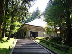
Chūson-ji, a World Heritage site in Hiraizumi | |||
| |||
 Location of Hiraizumi in Iwate Prefecture | |||
 Hiraizumi
| |||
| Coordinates: 38°59′01″N 141°07′02″E / 38.98361°N 141.11722°ECoordinates: 38°59′01″N 141°07′02″E / 38.98361°N 141.11722°E | |||
| Country | Japan | ||
| Region | Tōhoku | ||
| Prefecture | Iwate | ||
| District | Nishiiwai | ||
| Government | |||
| • -Mayor | Masayoshi Sugawara (since September 2010) | ||
| Area | |||
| • Total | 63.39 km2 (24.48 sq mi) | ||
| Population (February 2014) | |||
| • Total | 7,976 | ||
| • Density | 126/km2 (330/sq mi) | ||
| Time zone | Japan Standard Time (UTC+9) | ||
| - Tree | Cryptomeria | ||
| - Flower | Sakura | ||
| - Bird | Japanese bush warbler | ||
| Phone number | 0191-46-2111 | ||
| Address | 45-2 Hiraizumi Shirayama, Hiraizumi-chō, Nishi-Iwai-gun, Iwate-ken 029-4192 | ||
| Website | Official website | ||


Hiraizumi (平泉町 Hiraizumi-chō) is a town located in Nishiiwai District, Iwate Prefecture, Japan. As of February 2014, the town had an estimated population of 7,976 and a population density of 126 persons per km². The total area was 63.39 km².
It is noted for the Historic Monuments and Sites of Hiraizumi, which achieved UNESCO World Heritage Site status in 2011 .
Geography
Hiraizumi is the smallest municipality in Iwate Prefecture in terms of area. located in a basin in south-central Iwate Prefecture, surrounded by the Kitakami Mountains.
Neighboring municipalities
- Iwate Prefecture
History
The area of present-day Hiraizumi was part of ancient Mutsu Province. It was the home of the Hiraizumi Fujiwaras for about 100 years in the late Heian era and most of the following Kamakura period. At the same time it served as the de facto capital of Ōshū, an area containing nearly a third of the Japanese land area. At its height the population of Hiraizumi reached 50,000[1] or more than 100,000,[2] rivaling Kyoto in size and splendor.
The first structure built in Hiraizumi may have been Hakusan Shrine on top of Mount Kanzan (Barrier Mountain). A writer in 1334 recorded that the shrine was already 700 years old. Although rebuilt many times, the same shrine is still standing in the same location.
In about 1100, Fujiwara no Kiyohira moved his home from Fort Toyoda in present-day Esashi, in the city of Ōshū to Mount Kanzan in Hiraizumi. This location was significant for several reasons. Kanzan is situated at the junction of two rivers, the Kitakami and the Koromo. Traditionally the Koromo River served as the boundary between Japan to the south and the Emishi peoples to the north. By building his home south of the Koromo, Kiyohira (half Emishi himself) demonstrated his intention to rule Ōshū without official sanction from the court in Kyoto. Kanzan was also directly on the Ōshū Kaido, the main road leading from Kyoto to the northern lands as they opened up. Kanzan was also seen as the exact center of Ōshū which stretched from the Shirakawa Barrier in the south to Sotogahama in present-day Aomori Prefecture.
Kiyohira built the large temple complex on Kanzan known as Chūson-ji.[3] The first structure was a large pagoda at the very top of the mountain. In conjunction with this he placed small umbrella reliquaries (kasa sotoba) every hundred meters along the Ōshū kaido decorated with placards depicting Amida Buddha painted in gold. Other pagodas, temples and gardens followed including the Konjikido, a jewel box of a building intended to represent the Buddhist Pure Land and the final resting place of the Fujiwara lords.
Hiraizumi's golden age lasted for nearly 100 years, but after the fall of the Fujiwara the town sank back into relative obscurity, and most of the buildings that gave the town its cultural prominence were destroyed. When the poet Matsuo Bashō saw the state of the town in 1689 he penned a famous haiku about the impermanence of human glory:
- Natsu kusa ya! / Tsuwamono-domo ga / yume no ato
- Ah, summer grasses! / All that remains / Of the warriors' dreams. (1689) [4]
The modern Hiraizumi village was created on April 1, 1889 with the establishment of the municipality system. Hiraizumi was raised to town status on October 1, 1953. It annexed neighboring Nagashima village on April 15, 1955. The town lost some land to the city of Ichinoseki on September 1, 1956 and again on May 1, 1964.
Economy
The local economy is based on agriculture and tourism.
Transportation
Highway
- Tōhoku Expressway – Chusonji PA – Hiraizumi-Maezawa IC
- Japan National Route 4
International relations
![]() China – Tiantai County, Zhejiang Province, China – friendship city since 2010
China – Tiantai County, Zhejiang Province, China – friendship city since 2010

Local attractions
Hiraizumi has a number of officially listed National Treasures and other culturally or historically notable sites.
Buddhist temples
- Chūson-ji, including the Konjikidō Golden Hall
- Mōtsū-ji with a 'Pure Land' style Jōdo Garden
- The ruins of Kanjizaiō-in with its 'Pure Land' style Jōdo Garden
- The ruins of Muryokō-in (無量光院)
- Takkoku no Iwaya Bishamon Hall (達谷窟毘沙門堂)
Other places
- Takadachi Gikeidō (高館義経堂)
- The Yanagi no Gosho Site (柳之御所遺跡)
References
- ↑ Tertius Chandler, "Four Thousand Years of Urban Growth: An Historical Census", The Edwin Mellen Press, Lewiston (1987).
- ↑ Toshio Sanuki, "Toshi no Seisui Rankingu (Rise and Fall Ranking of Urbans)", Jiji Tsushin Sha, Tokyo (1996).
- ↑ Sansom, George (1958). A History of Japan to 1334. Stanford University Press. p. 254,326. ISBN 0804705232.
- ↑ Basho's Haiku at Haiku Poets Hut
External links
![]() Media related to Hiraizumi, Iwate at Wikimedia Commons
Media related to Hiraizumi, Iwate at Wikimedia Commons
| Wikivoyage has a travel guide for Hiraizumi. |
- Official website (Japanese)
- Official website (Japanese)(English)(Chinese)(Korean)
- The Golden Land of Hiraizumi (movie) (Japanese)(English)(simplified Chinese)
| Core city | ||
|---|---|---|
| Cities | ||
| Isawa District | ||
| Iwate District | ||
| Kamihei District | ||
| Kesen District | ||
| Kunohe District | ||
| Ninohe District | ||
| Nishiiwai District | ||
| Shimohei District | ||
| Shiwa District | ||
| Waga District | ||