Hingoli district
| Hingoli district हिंगोली जिल्हा | |
|---|---|
| District of Maharashtra | |
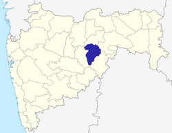 Location of Hingoli district in Maharashtra | |
| Country | India |
| State | Maharashtra |
| Administrative division | Aurangabad division |
| Headquarters | Hingoli |
| Tehsils | 1. Hingoli, 2. Kalamnuri, 3. Sengaon, 4. Aundha Nagnath, 5. Basmath |
| Government | |
| • Lok Sabha constituencies | Hingoli |
| • Assembly seats | 3 |
| Area | |
| • Total | 4,526 km2 (1,747 sq mi) |
| Population (2011) | |
| • Total | 1,177,345[1] |
| • Urban | 15.60 |
| Website | Official website |
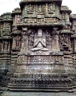
Hingoli district (Marathi: हिंगोली जिल्हा) is an administrative district in the state of Maharashtra in India. The district headquarters are located at Hingoli. The district occupies an area of 4,526 km² and has a population of 11,77,345 of which 15.60% were urban (as of 2011).[2] One of the twelve Jyotirlinga shrines, the Aundha Nagnath is located in Hingoli district.
As of 2011 it is the third least populous district of Maharashtra (out of 36), after Sindhudurg and Gadchiroli.[1]
History
.
The territory of the present district became part of Bombay state in 1956 and Maharashtra state in 1960 as part of Parbhani district. This district was carved out from Parbhani district on 1 May 1999 with five own tahsil 1.hingoli 2.kalamanuri 3.sengaon 4.Aundha naganath 5.basamat
- Mallinath Digambar Jain Temple, Shirad Shahpur,
- Aundha Nagnath is one of the famous place in Hingoli district,
- Tulja Devi Sansthan Ghota, Tahsil - Hingoli,
- Sant Namdev Sansthan Narsi, Giroli,
- Tulja Bhavani Devi Temple, or Tulaja Devi Sansthan, Kalamnuri
- Jaleshwar Mahadev Temple(present in the lake), Hingoli
- Shri Datta Mandir, Mangalwara, Hingoli
- Dakshinmukhi Hanuman temple, Khatkali, SRP camp area, Hingoli
Economy
In 2006 the Ministry of Panchayati Raj named Hingoli one of the country's 250 most backward districts (out of a total of 640).[5] It is one of the twelve districts in Maharashtra currently receiving funds from the Backward Regions Grant Fund Programme (BRGF).[5]
Divisions
This district is divided into two sub-divisions, which are further divided into five talukas. Hingoli sub-division is divided into three talukas: Hingoli, Kalamnuri and Sengaon. Basmath sub-division is divided into two talukas: Aundha and Basmath.
There are three Vidhan Sabha constituencies in this district: Basmath, Kalamnuri and Hingoli. All three are part of Hingoli Lok Sabha constituency.[6]
Demographics
According to the 2011 census Hingoli district has a population of 1,177,345,[1] roughly equal to the nation of Timor-Leste[7] or the US state of Rhode Island.[8] This gives it a ranking of 401st in India (out of a total of 640).[1] The district has a population density of 244 inhabitants per square kilometre (630/sq mi) .[1] Its population growth rate over the decade 2001-2011 was 19.43%.[1] Hingoli has a sex ratio of 942 females for every 1000 males,[1] and a literacy rate of 78.17%.[1]
See also
Notes
- 1 2 3 4 5 6 7 8 "District Census 2011". Census2011.co.in. 2011. Retrieved 2011-09-30.
- ↑ "Archived copy". Archived from the original on January 11, 2010. Retrieved August 27, 2009.
- ↑ http://hingoli.nic.in/Ntouristplace.html
- ↑ https://www.maharashtratourism.gov.in/docs/default-source/district-draft-toursim-plans/hingoli-district.pdf?sfvrsn=2
- 1 2 Ministry of Panchayati Raj (September 8, 2009). "A Note on the Backward Regions Grant Fund Programme" (PDF). National Institute of Rural Development. Retrieved September 27, 2011.
- ↑ "Districtwise List of Assembly and Parliamentary Constituencies". Chief Electoral Officer, Maharashtra website. Archived from the original on March 18, 2010. Retrieved 2009-03-24.
- ↑ US Directorate of Intelligence. "Country Comparison:Population". Retrieved 2011-10-01.
Timor-Leste 1,177,345 July 2011 est.
- ↑ "2010 Resident Population Data". U. S. Census Bureau. Archived from the original on January 1, 2011. Retrieved 2011-09-30.
Rhode Island 1,052,567
External links
 |
Buldana district | Washim district | | |
| |
Yavatmal district | |||
| ||||
| | ||||
| Parbhani district | Nanded district |
| Topics | |||||||||||||||||||||||
|---|---|---|---|---|---|---|---|---|---|---|---|---|---|---|---|---|---|---|---|---|---|---|---|
| Regions | |||||||||||||||||||||||
| Divisions and Districts |
| ||||||||||||||||||||||
| Million-plus cities in Maharashtra | |||||||||||||||||||||||
| Other cities with municipal corporations | |||||||||||||||||||||||
Portal: Maharashtra | |||||||||||||||||||||||
| Rivers |
|    | |||||||||||||||||||||||||
|---|---|---|---|---|---|---|---|---|---|---|---|---|---|---|---|---|---|---|---|---|---|---|---|---|---|---|---|
| Dams, barrages | |||||||||||||||||||||||||||
| Geographical features / regions | |||||||||||||||||||||||||||
| Riparian districts |
| ||||||||||||||||||||||||||
| Cities | |||||||||||||||||||||||||||
| Languages / people | |||||||||||||||||||||||||||
| Coalfields | |||||||||||||||||||||||||||
| Oil / gas fields | |||||||||||||||||||||||||||
| Industries |
| ||||||||||||||||||||||||||
| Transport | |||||||||||||||||||||||||||
| Related topics | |||||||||||||||||||||||||||
| Other basins | |||||||||||||||||||||||||||
Coordinates: 19°43′00″N 77°09′00″E / 19.7167°N 77.15°E