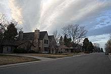
Hilltop, Denver
Hilltop is a neighborhood of Denver, Colorado. According to the Piton Foundation, in 2007, the population of the neighborhood was 8,623; in 2000, the average household income was $117,835, and there were 3,724 housing units.[1]
Boundaries
The neighborhood is bordered on the west by Colorado Boulevard, on the north by Severn Ave. and on the south by East Alameda Avenue. The Eastern border is uneven, but includes Monaco Parkway at the northeast corner of the neighborhood and then zigzags south and west to the west of Crestmoor Park. Part of the Southern border shares a boundary with the City of Glendale.
Landmarks
The Hilltop neighborhood gets it name from the fact that it is higher in elevation than the surrounding parts of the city. In the center of the neighborhood is Cranmer Park, with a view of the Front Range mountains. The Graland Country Day School, an independent, co-educational day school for grades K-8 is located in the neighborhood, as is Temple Emanuel. Hilltop is home to several other notable structures, including the Joshel House, Amter Residence, and Cranmer House.
Character
Hilltop is one of Denver's wealthiest neighborhoods. It was developed in the 1940s and 1950s,[2] but now many of the original houses are being replaced with larger homes on the medium-sized lots.[3]
References
- ↑ Piton Foundation, Neighborhood summary, retrieved 2009-03-16
- ↑ Westword
- ↑ Denver Real Estate: Hilltop/Crestmoor
Coordinates: 39°43′04″N 104°55′20″W / 39.71784°N 104.92226°W
Neighborhoods of the City and County of Denver, Colorado | ||
|---|---|---|
| Central | 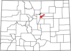 | |
| North |
| |
| Northeast | ||
| Northwest |
| |
| South |
| |
| Southeast |
| |
| East |
| |
| West |
| |
| Other |
| |
| ||