Hilliard, Ohio
| Hilliard, Ohio, United States | |
|---|---|
| City | |
|
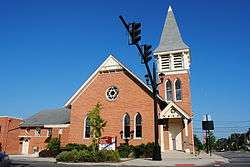
Hilliard United Methodist Church, built 1883 | |
 Location of Hilliard within Ohio | |
 Location of Hilliard within Franklin County | |
| Coordinates: 40°2′4″N 83°8′34″W / 40.03444°N 83.14278°WCoordinates: 40°2′4″N 83°8′34″W / 40.03444°N 83.14278°W | |
| Country | United States |
| State | Ohio |
| County | Franklin |
| Government | |
| • Mayor | Donald Schonhardt (R)[1] |
| Area[2] | |
| • Total | 13.34 sq mi (34.55 km2) |
| • Land | 13.17 sq mi (34.11 km2) |
| • Water | 0.17 sq mi (0.44 km2) |
| Elevation[3] | 935 ft (285 m) |
| Population (2010)[4] | |
| • Total | 28,435 |
| • Estimate (2013[5]) | 31,012 |
| • Density | 2,159.1/sq mi (833.6/km2) |
| Time zone | Eastern (EST) (UTC-5) |
| • Summer (DST) | EDT (UTC-4) |
| ZIP code | 43026 |
| Area code(s) | 614 |
| FIPS code | 39-35476[6] |
| GNIS feature ID | 1056881[3] |
| Website | www.hilliardohio.gov |
Hilliard is a city in Franklin County, Ohio, United States. The population was 28,435 at the 2010 census with a census estimate of 31,012 in 2013. It is a suburb of Columbus, Ohio and part of Norwich Township. Hilliard is the home of the Early Television Museum.
Geography
Hilliard is located at 40°2′4″N 83°8′34″W / 40.03444°N 83.14278°W (40.034310, -83.142678).[7] It is bordered on the east by Columbus and Upper Arlington, on the north by Columbus [8] and Dublin, on the south by Galloway and Columbus, and to the west lies open farmland. Downtown Columbus lies in a distance to the southeast, its skyline visible at times when crossing bridges. The only major highway that runs through Hilliard is I-270, which runs north and south slightly east of the middle of the city.
According to the United States Census Bureau, the city has a total area of 13.34 square miles (34.55 km2), of which 13.17 square miles (34.11 km2) is land and 0.17 square miles (0.44 km2) is water.[2]
History
In 1852, John Reed Hilliard bought 10 acres (40,000 m2) of farmland in western Franklin County, Ohio from Hoseah High and Abraham Wendell. Geographically, the Hilliard area is between Big Darby Creek on the west and the Scioto River on the east.[9] Originally called Hilliard’s Station, the town grew around the railroad route of the Piqua and Indiana Railroad station, which bisected the former Hilliard farmland. Hilliard’s Station served as an ideal shipping point for agricultural products going to market and supplies coming to the farmers in the area. The original Hilliard area was platted by John Hilliard on September 1, 1853.
Until the mid 20th century, the railroad station and Main Street were the town center. In 1854, a post office was established in Hilliard’s Station and the word Station was dropped from the town name. The Village of Hilliard became incorporated on July 13, 1869 with a population of 280 residents. In 1886 the first railroad station was located on the north side of the tracks, west of Main Street, and remained there until 1962 when all railroad services ceased. The original train station has been restored and remains in Hilliard’s historical Weaver Park. The original platted area contained a mix of residences and businesses of varying ages and architecture.
The construction of three large residential subdivisions in the 1950s brought explosive growth to Hilliard. The connection to the Columbus regional sewer and water systems in the 1960s opened up the area to development. The Village of Hilliard gained city status officially from the Ohio Secretary of State by attaining a population of 5,633 on December 12, 1960.
With the completion of the I-270 outerbelt in the 1980s, a second wave of explosive growth came to the area. Land uses in Hilliard continue to be a mix of residential and commercial development. A rich heritage of residential structures and architectural styles can be found in the historic district along Norwich Street.[9][10]
Demographics
| Historical population | |||
|---|---|---|---|
| Census | Pop. | %± | |
| 1870 | 282 | — | |
| 1880 | 400 | 41.8% | |
| 1890 | 338 | −15.5% | |
| 1900 | 376 | 11.2% | |
| 1910 | 370 | −1.6% | |
| 1920 | 451 | 21.9% | |
| 1930 | 465 | 3.1% | |
| 1940 | 583 | 25.4% | |
| 1950 | 610 | 4.6% | |
| 1960 | 5,633 | 823.4% | |
| 1970 | 8,369 | 48.6% | |
| 1980 | 7,996 | −4.5% | |
| 1990 | 11,796 | 47.5% | |
| 2000 | 24,230 | 105.4% | |
| 2010 | 28,234 | 16.5% | |
| Est. 2015 | 33,649 | [11] | 19.2% |
| US Census[12] | |||
2010 census
As of the 2010 census,[4] there were 28,435 people, 10,198 households, and 7,612 families residing in the city. The population density was 2,159.1 inhabitants per square mile (833.6/km2). There were 10,637 housing units at an average density of 807.7 per square mile (311.9/km2). The racial makeup of the city was 88.5% White, 3.0% African American, 0.2% Native American, 5.6% Asian, 0.8% from other races, and 1.9% from two or more races. Hispanic or Latino of any race were 2.3% of the population.
There were 10,198 households of which 44.5% had children under the age of 18 living with them, 61.8% were married couples living together, 9.2% had a female householder with no husband present, 3.7% had a male householder with no wife present, and 25.4% were non-families. 21.2% of all households were made up of individuals and 7.9% had someone living alone who was 65 years of age or older. The average household size was 2.77 and the average family size was 3.26.
The median age in the city was 35.9 years. 30.1% of residents were under the age of 18; 6.4% were between the ages of 18 and 24; 28.7% were from 25 to 44; 26.2% were from 45 to 64; and 8.6% were 65 years of age or older. The gender makeup of the city was 48.8% male and 51.2% female.
2000 census
As of the census[6] of 2000, there were 24,230 people, 8,577 households, and 6,492 families residing in the city. The population density was 2,174.8 people per square mile (839.8/km²). There were 8,957 housing units at an average density of 804.0 per square mile (310.4/km²). The racial makeup of the city was 85.1% White, 3.2% African American, 0.17% Native American, 1.48% Asian, 0.02% Pacific Islander, 5.72% from other races, and 1.32% from two or more races. Hispanic or Latino of any race were 4.56% of the population.
There were 8,577 households out of which 46.3% had children under the age of 18 living with them, 64.7% were married couples living together, 7.8% had a female householder with no husband present, and 24.3% were non-families. 19.5% of all households were made up of individuals and 5.7% had someone living alone who was 65 years of age or older. The average household size was 2.80 and the average family size was 3.26.
In the city the population was spread out with 32.1% under the age of 18, 5.5% from 18 to 24, 37.8% from 25 to 44, 17.4% from 45 to 64, and 7.2% who were 65 years of age or older. The median age was 33 years. For every 100 females there were 96.5 males. For every 100 females age 18 and over, there were 92.6 males.
The median income for a household in the city was $69,015, and the median income for a family was $76,207. Males had a median income of $50,551 versus $35,733 for females. The per capita income for the city was $28,496. About 0.6% of families and 2.2% of the population were below the poverty line, including 1.0% of those under age 18 and 8.3% of those age 65 or over.
Education
The Hilliard City School District encompasses all of the original Brown and Norwich Township boundaries, the actual city of Hilliard, a portion of Columbus that is about the same size as that within Hilliard, as well as parts of the city of Dublin, and parts of Galloway. There are fourteen elementary schools (Alton Darby, Avery, Beacon, Britton, Brown, Darby Creek, Hilliard Crossing, Hilliard Horizon, Hoffman Trails, J.W. Reason, Norwich, Ridgewood, Scioto Darby, and Washington), two sixth-grade schools (Station and Tharp), three middle schools (Heritage, Weaver, and Memorial), and three high schools (Darby, Davidson, and Bradley) in the district.[13] The high school sports teams are named the Panthers, Wildcats, and Jaguars, respectively. Also in the city of Hilliard is a K-8 Roman Catholic school: Saint Brendan School, and a K-8 Islamic school, Sunrise Academy.
The Columbus Metropolitan Library has a Hilliard branch located on Cemetery Road.
Public safety
Hilliard maintains its own Division of Police located at 5171 Northwest Parkway. The 55 Officer Division has a Patrol Bureau, Records Bureau, Detective Bureau, Special Investigations Unit, Property Room, Motorcycle Unit, Bike Patrol Unit, Community Resource/Training Bureau, and three K-9 Officers. The Hilliard Division of Police also provides police services for Norwich Township. Robert Fisher serves as Chief of Police.
Norwich Township provides fire protection for the City of Hilliard and Norwich Township. The Norwich Township Fire Department maintains three fire stations (Stations 81, 82 and 83). Station 81 is a joint venture between the City of Hilliard and Norwich Township, housing Norwich Township Fire Station 81 and the Hilliard Division of Police.
Recreation
For recreation, Hilliard has two pools (west and east), a Municipal Center/Senior Center next to the west pool, YMCA, and many public baseball and soccer fields, as well as basketball and sport activities
Community events
Fourth of July Festivities
Hilliard annually hosts a Fourth of July parade and has a moderately sized fireworks display that overlooks the west pool/municipal park.
Franklin County Fair
The Franklin County Fair also calls Hilliard its home.
Old Hilliardfest Art & Street Fair
The Old Hilliardfest Art & Street Fair is held in downtown Hilliard each year the second Saturday of each September and is sponsored by the Hilliard Civic Association. The festival includes several stages of music, ranging from professional acts to various talented community performers; a car show, featuring dozens of classic and modern cars; food vendors, including several food trucks; a large variety of community organizations, artists, and other various vendors; lots for kids to do, including inflatables, carnival games and rides, face painting, arts and crafts activities; and more.[14]
Sports
The largest sporting events in Hilliard are the football games of the three Hilliard high schools; Hilliard Bradley, Hilliard Darby, and Hilliard Davidson. Basketball for these high schools is also popular. Hilliard is also home to the Rahal Letterman Lanigan Racing team.
State Football Championships
Hilliard Davidson won the Division I State Championship in Football in 2006 and 2009.
State Cross Country Championships
Hilliard Davidson won both the Girls and Boys State Championships in Cross County in 2002. This is the only time in Division I Ohio High School history that the same school has won both in the same year. The boys team also placed second in the State in 2008, continuing the longest active streak of consecutive appearances at the state meet among Division I schools with 9. In 2011, the girls team went on to win the Regional meet and qualify for the state meet.
State Soccer Championship
Hilliard Davidson also won the State Championship in boys soccer in 2007. It was the first Soccer State Championship in Hilliard history.
State Volleyball Championships
Hilliard Darby Boys' Volleyball has won the State Championship in the 2012-2013 and 2014-2015 school year. In 2012, they were State Runners-up. They have also appeared in the State Final Four in 2003, 2005, 2007, 2008, 2010, 2011, and 2014. Prior to the split of the Hilliard schools, Hilliard High School won a state championship in 1991.
Other sports
- Hilliard Weaver Middle School 5th in the state for lacrosse in 2013
- Hilliard Darby Softball won the State Championship in 2000, as well as made it to the State Semi-Final game in 2009
- Hilliard Davidson was 6th in the state for wrestling in 2006
- Hilliard Davidson baseball finished the 2007 season with a #7 state ranking
Hilliard youth organizations
Some youth club teams include the Northwest Football League (FWFL), the Hilliard Baseball Association (HBA), Hilliard Wildcats High School Hockey Club, the Hilliard Girls Softball Association (HGSA), the Hilliard Optimist Basketball League (HOBL), Hilliard Girls Field Hockey, the Hilliard Ohio Soccer Association (HOSA),[15] the Hilliard Youth Lacrosse Association (HYLA), and Northwest FC Youth Soccer (NWFC).
Schools
- Hilliard City School District
- Hilliard Davidson High School
- Hilliard Darby High School
- Hilliard Bradley High School
- Hilliard Memorial Middle School
- Hilliard Weaver Middle School
- Hilliard Heritage Middle School
- Alton Darby Elementary
- Britton Elementary
- Norwich Elementary
- Darby Creek Elementary
- J.W. Reason Elementary
- Ridgewood Elementary
- Beacon Elementary
- Avery Elementary
- Washington Elementary
- Horizon Elementary
- Crossing Elementary
- Scioto Darby Elementary
- Hoffman Trails Elementary
- Brown Elementary
- Sixth Grade Tharp
- Sixth Grade Station
References
- ↑ Budzak, Gary (9 February 2011). "Schonhardt unopposed in Hilliard mayoral GOP primary". ThisWeek Community News. Retrieved 14 January 2016.
- 1 2 "US Gazetteer files 2010". United States Census Bureau. Archived from the original on January 24, 2012. Retrieved 2013-01-06.
- 1 2 "US Board on Geographic Names". United States Geological Survey. 2007-10-25. Retrieved 2008-01-31.
- 1 2 "American FactFinder". United States Census Bureau. Retrieved 2013-01-06.
- ↑ "Population Estimates". United States Census Bureau.
- 1 2 "American FactFinder". United States Census Bureau. Retrieved 2008-01-31.
- ↑ "US Gazetteer files: 2010, 2000, and 1990". United States Census Bureau. 2011-02-12. Retrieved 2011-04-23.
- ↑ http://gis.columbus.gov/oss/
- 1 2 "Community | Hilliard Area Chamber of Commerce | Hilliard, Ohio". Hilliardchamber.org. 1960-12-12. Retrieved 2011-03-04.
- ↑ Archived February 1, 2015, at the Wayback Machine.
- ↑ "Annual Estimates of the Resident Population for Incorporated Places: April 1, 2010 to July 1, 2015". Retrieved July 2, 2016.
- ↑ Data in historical population table from Annual Report of the Secretary of State to the Governor of Ohio; "American Factfinder". US Census Bureau..
- ↑ Hilliard City School District. "Hilliard City School District Facts and Figures". Retrieved 2006-07-01.
- ↑ "Old Hilliardfest Art & Street Fair". Retrieved 2015-06-12.
- ↑ Archived January 11, 2008, at the Wayback Machine.
External links
Municipalities and communities of Franklin County, Ohio, United States | ||
|---|---|---|
| Cities |  | |
| Villages | ||
| Townships | ||
| CDPs | ||
| Unincorporated communities | ||
| Footnotes | ‡This populated place also has portions in an adjacent county or counties | |