Hill Street (Los Angeles)

Hill Street is a major north-south thoroughfare in Los Angeles, measuring 4.8 miles (7.7 km) in length. It starts on Martin Luther King, Jr. Boulevard near the campus of USC, and passes north through Downtown Los Angeles, past such landmarks as Pershing Square, the Subway Terminal Building, Angels Flight,[n 1] Fort Moore and Chinatown. Hill Street merges with the Arroyo Seco Parkway near Dodger Stadium.
History
Hill Street was originally laid out in 1849 by Edward Ord. At that time, the street ended in the north at 1st Street, where the foot of Fort Hill sat. The stretch of modern Hill Street north of the old hill was originally named Calle del Toro (Bull Street),[1][2][3] was renamed Castelar in 1874,[4] and finally renamed North Hill in 1960.[5]
Public transportation
The Metro Red Line and Metro Purple Line run underneath Hill Street between 1st and 4th Streets and operate the Civic Center and Pershing Square stations along the way. Metro Local lines 2, 4, 10, 28, 81, 83, 90, 91, 94, and 96 run along the surface, as well as Metro Rapid lines 728 and 794.
Education
Number of schools are located at or nearby Hill Street. They include Cathedral High School, Castelar Elementary School, High School for the Visual and Performing Arts, Evans Community Adult School, the William Jefferson Clinton Middle School, Orthopaedic Hospital Medical Magnet High School, Santee Education Complex, and Los Angeles Trade-Tech College.
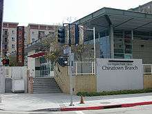
Los Angeles Public Library has the Chinatown branch located at Hill and Ord Streets.
Landmarks
- John Adams Middle School
- Cathedral of Our Lady of the Angels
- Fort Moore Pioneer Memorial
- Garfield Building
- Grand Park
- Grand Central Market
- Los Angeles County Hall of Records
- Los Angeles County Superior Court's Stanley Mosk Courthouse
- May Company Garage - 1926 - one of the Nation's first parking structures (Los Angeles Historic-Cultural Monument No. 1001)
- The Mayan
- Pershing Square
Notes
- ↑ A 2001 civic ceremony held in honor of mishap casualty Leon Praport at the Hill Street entrance to Angels Flight, where conductor David Woodard premiered "An Elegy for Two Angels," necessitated a midday street cordon.
References
- ↑ Cameron, Tom (September 1, 1953). "What's In A Street Name?". Los Angeles Times. p. A5. (subscription required (help)).
Another is called Calle del Toro, which was changed to Castelar.
Alternate Link via ProQuest. - ↑ "The Street Scene". Los Angeles Times. August 31, 1980. p. y36. (subscription required (help)). Alternate Link via ProQuest.
- ↑ "Early Map is Odd Document: Explains Derivation of Names of Streets Shows Reason Why Main and Spring Join Survey is Made Before City Incorporated". Los Angeles Times. November 30, 1924. p. E3. (subscription required (help)). Alternate Link via ProQuest.
- ↑ "Common Council". Los Angeles Herald. 1 (114). February 14, 1874. p. 3 – via California Digital Newspaper Collection.
A petition was received from a number of property owners, requesting that Grasshopper street be changed to Union Avenue, Bull street to Castelar, and Wasp street to Yale street. The petition was favorably received and a special committee, in conjunction with the City Attorney, was appointed to draft an ordinance to comply with the request.
- ↑ "Castelar St. Now Is Hill". Los Angeles Times. March 25, 1960. p. 29. (subscription required (help)).
Castelar St., running past New Chinatown between Sunset Blvd. and Bernard St., was taken off the map yesterday by the City Council. The name change had the backing of the Board of Works, New Chinatown Chamber of Commerce and Castelar St. residents. The Historical Society of Southern California offered no objection, saying the name Castelar had little historical significance.
Alternate Link via ProQuest.