High Tor State Park
| High Tor State Park | |
|---|---|
|
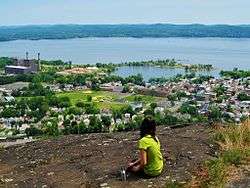
View from atop High Tor Mountain with the Village of Haverstraw, the Hudson River, and Westchester County in the distance. | |
 Location of High Tor State Park within New York State | |
| Type | State park |
| Location |
415 South Mountain Road New City, New York[1] |
| Nearest city | Haverstraw, New York |
| Coordinates | 41°11′16″N 73°59′20″W / 41.1877°N 73.989°WCoordinates: 41°11′16″N 73°59′20″W / 41.1877°N 73.989°W |
| Area | 691 acres (2.80 km2)[2] |
| Created | 1943[3] |
| Operated by | |
| Visitors | 21,524 (in 2014)[4] |
| Website | High Tor State Park |
High Tor State Park is a 691-acre (2.80 km2) state park[2] on the north edge of the Town of Clarkstown in Rockland County, New York, United States.[5] The park is located on South Mountain, which has two peaks, High Tor and Little Tor.[6] Its highest peak, High Tor, is 797 feet (243 m) high.[7]
Park description
High Tor State Park is intended for day use during the summer months, and contains picnic tables, a pool and showers, hiking trails, and a food concession. The Long Path passes through the park.[8]

The park contains two peaks: High Tor at 797 feet (243 m),[7] and Little Tor at 620 feet (190 m).[9] They are the highest peaks in not only the park, but in all of the Hudson Palisades. The skyline of New York City can be seen from the summit of High Tor.[3]
High Tor was used as a signal point during the American Revolution for the colonists,[3] and was used as an air raid watch during World War II. Famous composer Kurt Weill worked as an air raid warden there.
See also
- High Tor, a 1936 play by Maxwell Anderson that focuses on the summit within the park
- List of New York state parks
References
- ↑ "High Tor State Park - Getting There". NYS Office of Parks, Recreation & Historic Preservation. Retrieved November 3, 2015.
- 1 2 "Section O: Environmental Conservation and Recreation, Table O-9". 2014 New York State Statistical Yearbook (PDF). The Nelson A. Rockefeller Institute of Government. 2014. p. 672. Retrieved February 19, 2016.
- 1 2 3 "High Tor State Park, NY". Palisades Parks Conservancy. Retrieved November 3, 2015.
- ↑ "State Park Annual Attendance Figures by Facility: Beginning 2003". Data.ny.gov. Retrieved November 3, 2015.
- ↑ "High Tor State Park". Geographic Names Information System. United States Geological Survey. Retrieved November 3, 2015.
- ↑ Green, Stella; Zimmerman, H. Neil (2008). "The Tors, High and Low". Explorer's Guide 50 Hikes in the Lower Hudson Valley: Hikes and Walks from Westchester County to Albany (2nd ed.). The Countryman Press. pp. 107–110. Retrieved November 3, 2015.
- 1 2 "High Tor". Geographic Names Information System. United States Geological Survey. Retrieved November 3, 2015.
- ↑ "High Tor State Park". NYS Office of Parks, Recreation & Historic Preservation. Retrieved November 3, 2015.
- ↑ "Little Tor". Geographic Names Information System. United States Geological Survey. Retrieved November 3, 2015.
External links
- New York State Parks: High Tor State Park
- NY-NJTC: High Tor State Park
- Palisades Parks Conservancy: High Tor State Park
- NY-NJ-CT Botany Online: Facts about High Tor