Heysen Tunnels
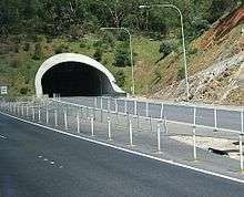 Portal of the Heysen tunnel | |
| Overview | |
|---|---|
| Location | Adelaide Hills south east of Adelaide |
| Route |
|
| Operation | |
| Constructed | 1998 |
| Opened | May 2000 |
| Traffic | automotive, including commuters and heavy freight |
| Toll | N/A |
| Vehicles per day | 45,700[1] |
| Technical | |
| Length | 500 metres (1,600 ft) |
| Number of lanes | 3 in each tunnel |
| Operating speed | 90 kilometres per hour (56 mph) |
| Tunnel clearance | 5.3 metres (17 ft)[2] |
The Heysen Tunnels are twin tube road tunnels which carry the South Eastern Freeway under Eagle On The Hill in the Mount Lofty Ranges in South Australia. The tunnels were excavated using a tunnelling machine normally used in heavy-duty mining operations which tunnelled through 500 metres of rock for each tunnel at an average rate of 3 metres per day.[3] The tunnels were completed in 1998 and officially opened in May 2000. Each tunnel carries 3 lanes of traffic. On average, they carry a total of 45,700 vehicles per day.[1] The maximum height of vehicles permitted in the tunnels is 5.3 metres (17 ft), the same as the Crafers and Mt Osmond interchanges. Laser height detectors monitor traffic to provide warnings to drivers before they attempt to enter the tunnel.[2]
The tunnels are named after artist Sir Hans Heysen.
See also
![]() Australian Roads portal
Australian Roads portal
References
- 1 2 Annual Average Daily Traffic Estimates 24 hour two-way flow (PDF) (Map). Government of South Australia, Department of Planning, Transport and Infrastructure. 1 March 2015. Map MT12. Retrieved 3 April 2015.
- 1 2 "South Eastern Freeway". Government of South Australia, Department of Planning, Transport and Infrastructure. 10 February 2015. Over-Height vehicles. Retrieved 4 April 2015.
- ↑ "Heysen Tunnels Construction". Government of South Australia, Department for Transport, Energy and Infrastructure. 13 August 2004. Archived from the original on 2007-08-31. Retrieved 2007-07-14.
Coordinates: 34°58′27″S 138°40′34″E / 34.974089°S 138.676072°E