Hestur
| Hestur | |
|---|---|
| Island | |
|
West coast of Hestur | |
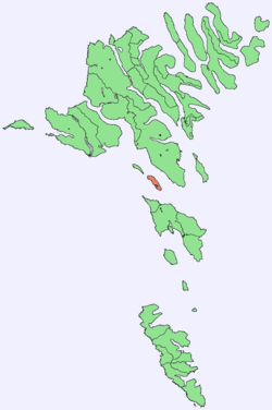 Location within the Faroe Islands | |
| State |
|
| Constituent country |
|
| Area | |
| • Total | 6.1 km2 (2.4 sq mi) |
| Area rank | 15 |
| Highest elevation | 421 m (1,381 ft) |
| Population (2012) | |
| • Total | 25 |
| • Rank | 13 |
| • Density | 4.1/km2 (11/sq mi) |
| Time zone | GMT (UTC+0) |
| • Summer (DST) | EST (UTC+1) |
| Calling code | 298 |

| Hestur | |
|---|---|
| Village | |
|
Hestur village | |
 Hestur Location in the Faroe Islands | |
| Coordinates: 61°57′27″N 6°53′13″W / 61.95750°N 6.88694°WCoordinates: 61°57′27″N 6°53′13″W / 61.95750°N 6.88694°W | |
| State |
|
| Constituent country |
|
| Island | Hestur |
| Municipality | Tórshavnar |
| Time zone | GMT |
| • Summer (DST) | EST (UTC+1) |
| Postal code | FO 280 |
Hestur (Danish: Hestø) is an island in the central Faroe Islands, to the west of Streymoy and the south of Koltur. Hestur means horse in Faroese.
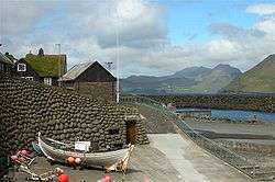
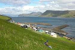
On the west coast is a guillemot colony. In the north there is moorland with four small lakes, of which Fagradalsvatn is the largest. At Hælur, Hestur's southernmost tip, there is a lighthouse. The island has one settlement, a village also named Hestur on the east coast. The village enjoys the view over Gamlarætt and Velbastaður on Streymoy.
History
The island has been settled since Viking times, the old settlement was at Hælur, the southern tip of the island. Due to it being the sun-ward side of the island cereal ripened better there than anywhere else on the island. But due to extreme difficulties in landing boats there, the village was abandoned and the current village of Hestur was established.
In 1919 a fishing accident resulted in the deaths of one-thirds of Hestur's men. In an attempt to fight the depopulation of the village, a swimming pool was built on the island in 1974. On the southern part of the island by the lake Fagradalsvatn, one can camp. Hestur's postal code is FO 280. Since 1 January 2005 the island has been part of the municipality of Tórshavn.
Important Bird Area
The coastline of the island has been identified as an Important Bird Area by BirdLife International because of its significance as a breeding site for seabirds, especially Atlantic puffins (25,000 pairs), European storm petrels (5000 pairs) and black guillemots (50 pairs).[1]
Mountains
The island has the following four mountains
| Name | Height |
|---|---|
| Múlin | 421 m |
| Eggjarrók | 421 m |
| Nakkur | 296 m |
| Álvastakkur | 125 m |
Gallery
 Hestur
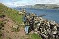 Hestur
See also
References
- ↑ BirdLife International. (2012). Important Bird Areas factsheet: Hestur. Downloaded from http://www.birdlife.org on 2012-02-23.
External links
- Maps of Hestur Island
- Official site of Faroe Islands
- personal website with 6 aerial photos of Hestur
| Wikimedia Commons has media related to Hestur. |
| Look up Hestur in Wiktionary, the free dictionary. |
Islands of the Faroe Islands | ||
|---|---|---|