Hesters Store, North Carolina
| Hesters Store | |
|---|---|
| Unincorporated community | |
 Hesters Store Location within the state of North Carolina | |
| Coordinates: 36°19′48″N 79°07′50″W / 36.33000°N 79.13056°WCoordinates: 36°19′48″N 79°07′50″W / 36.33000°N 79.13056°W | |
| Country | United States |
| State | North Carolina |
| County | Person |
| Time zone | Eastern (EST) (UTC-5) |
| • Summer (DST) | EDT (UTC-4) |
| ZIP codes | 27541, 27291 |
| Area code(s) | 336 |
Hesters Store is an unincorporated community in Person County, North Carolina. It lies at the intersection of Gordonton Road(State Road 1102) with Hesters Store Road(State Road 1162) and Wilson Road(State Road 1162). Derives its name from a country store that stood near the intersection for more than a century. In 1994, the most recent country store structure was converted into a fire station, the Hesters Store station of the Hurdle Mills Volunteer Fire Department.


Neighboring North Carolina communities and municipalities include: Bushy Fork, Hurdle Mills, Gordonton, Roxboro, Leasburg, Yanceyville, Prospect Hill.
Municipalities and communities of Person County, North Carolina, United States | ||
|---|---|---|
| City | 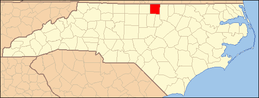 | |
| CDP | ||
| Unincorporated communities | ||
| Footnotes | ‡This populated place also has portions in an adjacent county or counties | |
This article is issued from Wikipedia - version of the 11/25/2014. The text is available under the Creative Commons Attribution/Share Alike but additional terms may apply for the media files.