Hertford
| Hertford | |
 Parliament Square, Hertford Town Centre |
|
 Hertford |
|
| Population | 26,783 (2011 Census)[1] |
|---|---|
| OS grid reference | TL325125 |
| – London | 19.2 mi (30.9 km) S |
| Civil parish | Hertford |
| District | East Hertfordshire |
| Shire county | Hertfordshire |
| Region | East |
| Country | England |
| Sovereign state | United Kingdom |
| Post town | HERTFORD |
| Postcode district | SG13, SG14 |
| Dialling code | 01992 |
| Police | Hertfordshire |
| Fire | Hertfordshire |
| Ambulance | East of England |
| EU Parliament | East of England |
| UK Parliament | Hertford and Stortford |
| Website | www.hertford.gov.uk |
|
|
Coordinates: 51°47′42″N 0°04′41″W / 51.795°N 0.078°W
Hertford (/ˈhɑːrᵗfərd/) is the county town of Hertfordshire, England, and is also a civil parish in the East Hertfordshire district of the county. Forming a civil parish, the 2011 census put the population of Hertford at about 26,000.[2]
Toponomy
The earliest reference to the town appears in the Ecclesiastical History of the English People, written by Bede in 731 AD, which refers to "Herutford". "Herut" is the Old English spelling of "hart", meaning a fully mature stag; thus the meaning of the name is a ford where harts are found.[3] The Domesday Book of 1086 gives a spelling of "Hertforde".[4]
Governance
Hertford has been the county town of Hertfordshire since Saxon times when it was governed by the king's reeves. By the 13th century, the reeves had been replaced by a bailiff, elected by the burgesses. Charters of 1554 and 1589 established a common council of eleven chief burgesses and a bailiff. Another charter of 1605 changed the bailiff's title to mayor. In 1835, Hertford became a Municipal Corporation; the ratepayers elected twelve councillors, who chose four aldermen, aldermen and councillors composing the council. This body elected the mayor.[5]
Since 1974, Hertford has been within the East Hertfordshire district of Hertfordshire.The headquarters of Hertfordshire County Council is at County Hall in Hertford. East Herts District Council's offices almost adjoin County Hall, and there is also a Hertford Town Council based at Hertford Castle (see "Landmarks", below).
Geography
Hertford is at the confluence of four river valleys: the Rib, Beane and Mimram join the River Lea at Hertford to flow south toward the Thames as the Lee Navigation, after Hertford Castle Weir.The shared valley of the Lea and the Beane is called Hartham Common and this provides a large park to one side of the town centre running towards Ware and lying below the ridge upon which Bengeo is situated.
The town centre still has its medieval layout with many timber-framed buildings hidden under later frontages, particularly in St Andrew Street. Hertford suffers from traffic problems despite the existence of the 1960s A414 bypass called Gascoyne Way which passes close to the town centre. Plans have long existed to connect the A10 with the A414, by-passing the town completely. Nevertheless, the town retains very much a country-town feel, despite lying only 19.2 miles (30.9 km) north of Central London. This is aided by its proximity to larger towns such as Harlow, Bishop's Stortford and Stevenage where modern development has been focused.
|
Suburbs and estates
|
Nearby Hertford |

History
Possibly the first mention of the town was in 673 A.D.: the first synod of a number of the bishops in England was held either in Hertford or at Hartford, Cambridgeshire.[6] It was called by Theodore of Tarsus; decisions included the calculation of the date of Easter.[7] In 912 AD, Edward the Elder built two burhs (earthwork fortifications) close by the ford over the River Lea as a defence against Danish incursions. By the time of the Domesday Book, Hertford had two churches, two markets and three mills. The Normans began work on Hertford Castle, and Hertford Priory was founded by Ralph de Limesy.[8] King Henry II rebuilt the castle in stone, but in 1216, during the First Barons' War, it was besieged and captured after 25 days by Prince Louis of France.[9] The castle was regularly visited by English royalty and in 1358, Queen Isabella, wife of Edward II, died there. The priory was dissolved in 1536 and subsequently demolished[8] and in 1563, the Parliament of England met at the castle because of an outbreak of plague in London. Hertford grew and prospered as a market and county town; communication was improved by the construction of the Lea Navigation Canal in 1767 and the arrival of the railway in 1843.[10]
Economy
A fair amount of employment in the town is centred on County Hall (Hertfordshire County Council), Wallfields (East Hertfordshire District Council) and McMullens Brewery, one of a dwindling number of independent pre-1970 family brewers in the United Kingdom. Many residents commute to work in London.
Hertford differs from neighbouring towns as it lacks a modern shopping development (mall). However, it has most of the usual supermarkets. A Tesco store occupies part of the former Christ's Hospital Bluecoat Girls School, which closed down in 1985. Sainsburys opened a new store on part of the McMullens Brewery site in June 2012.[11] A Waitrose occupies a reasonably large store in the Bircherley Green Shopping area. The local branch of Woolworths closed for good on 27 December 2008, after the collapse of that store chain. There are fewer of the usual chain shops found in most high streets and this makes Hertford stand out from other "clone towns". There are a high number of independent shops in the town, with a variety of boutiques and salons.
Sport and leisure
Hertford has a leisure centre on Hartham Common. There is a Non-League football club Hertford Town F.C., which plays at Hertingfordbury Park. Bengeo Tigers Football Club is an award-winning[12] FA Charter Standard Community Football Club.[13]
People
- The band Deep Purple formed in Hertford in 1968.
- Alfred Russel Wallace who proposed a theory of natural selection at the same time as Charles Darwin lived in Hertford between the ages of five and thirteen and attended Hertford Grammar School.
- John Wilkes, the radical politician, was educated in Hertford.
- Sergeant Alfred Alexander Burt VC, soldier in the Hertfordshire Regiment who was born and lived in Hertford. He was awarded the Victoria Cross for his valour on 27 September 1915 during the Battle of Loos.[14]
- Captain W E Johns, Writer of the Biggles books was born in Bengeo, attended Hertford Grammar School and lived in Hertford.
- Samuel Stone, Puritan Minister who established the American town of Hartford, Connecticut with Thomas Hooker. He lived in Fore Street, Hertford and was baptised at All Saints Church. There is a statue commemorating him, close to the Hertford Theatre.
- Jane Wenham was tried at the Hertford Assizes for witchcraft in 1712. The jury found her guilty, one of the last in England to be convicted of this offence. Judge Powell had no choice but to condemn her to death, but through his influence she was later given a Royal Pardon.[15]
- Jack Trevor Story, the author of "The Trouble with Harry" and other works, was born in Hertford in 1917.
- Rupert Grint, the Harry Potter film star, comes from Hertford, and although he now lives outside the county town, he lived within Hertford when filming began on the Harry Potter series. He attended Richard Hale School before leaving after his GCSE exams in 2004. Other famous pupils at Richard Hale School are listed on that school's page.
- Dani Filth, singer of Cradle of Filth was born in Hertford, but grew up in Ipswich.
- Singer George Ezra was born and grew up in Hertford, attending Simon Balle School.
- International rugby union players Robbie Morris & Jamie George.
Landmarks

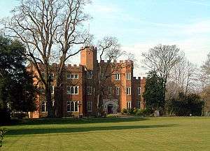
- In the town are the remains of the original Hertford Castle, principally a motte. The castle's gatehouse, the central part of which dates to a rebuild by Edward IV in 1463, is the home to Hertford Town Council. The Motte, from the original Motte and Bailey castle in Hertford, can be found just behind Castle Hall, a short distance from the modern castle.
- There are several churches in the town, All Saints', and St Andrew's, are late and mid 19th century respectively, although both stand on the sites of medieval places of worship.[16] In the northern suburb of Bengeo lies St Leonard's, a two-celled Norman church of considerable architectural interest.
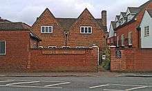
- In Railway Street can be found the oldest purpose-built Quaker Meeting House in the world, in use since 1670.
- The Parliament of England temporarily moved to Hertford during a plague outbreak in London in 1563.[17] This is why the main square in the town, Parliament Square, is so named, although it is a twentieth-century creation.
- The home of Alfred Russel Wallace (see above), now named Wallace House, can be found at 11 St. Andrew St. and is marked with a plaque.[18]
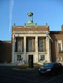
- Built in 1779, the Shire Hall was designed by Robert Adam.[19] The ground floor houses Court Rooms.
- The Hertford Corn Exchange was built on the site of a former gaol. After years in the doldrums it has now reverted to being a live entertainment venue.[20]
- In Cowbridge, there is a Prince Albert Cottage.[21] The first of these cottages was originally built in Hyde Park by the Society for Improving the Condition of the Labouring Classes in 1851 at the time of the Great Exhibition. Prince Albert was involved in their design and financing.
- Hertford Museum is housed in a 17th-century historic town house, with a Jacobean-style knot garden.
- A stained-glass window in St Andrew's Church is part of a fringe theory that links Hertford to the Knights Templar and the Holy Grail.[22]
Transport
Rail

Hertford serves as a commuter town for London, and has two stations :
- Hertford East (on the Hertford East Branch Line) provides a half-hourly service to London Liverpool Street (taking 52 minutes), via Tottenham Hale. The line is operated by Abellio Greater Anglia.
- Hertford North (on the Hertford Loop Line) has a service every 20 minutes off-peak to London Moorgate station (taking 50 minutes), via Finsbury Park (change for King's Cross) and hourly northwards to Stevenage (for onward connections via the East Coast Main Line) and Letchworth (change for Cambridge). Services are operated by Great Northern.
Road
The A414 main road now bypasses the town centre to the south and runs east to Harlow, the M11 and Chelmsford and runs west to Hatfield, the A1, St Albans and the M1. Hertford also lies just west of the A10 and the Kingsmead Viaduct which links it south to London and the M25 and north to Royston and Cambridge.
Bus and coach
- The town's bus services are run by a number of companies, most running from the bus station on Bircherley Green, destinations include Bishop's Stortford, Royston, Stevenage and Waltham Cross. Many of these routes receive subsidies from Hertfordshire County Council.
- The town also lies on the 724 coach route (operated by Arriva the Shires) which provides an hourly service from Harlow through the town and on to Hatfield, Welwyn Garden City, St Albans, Watford and Heathrow.
- Although bypassed by most National Express routes Hertford (Mill Road) is served by the 767 service which operates from Nottingham to Stansted Airport via Leicester and Luton Airport.
For all bus and coach timetables see Intalink.[23]
Education
There are numerous schools in Hertford: these include the Sele School, Richard Hale School and Simon Balle School at secondary level, with primaries of Hollybush JMI, Millmead Community School,[24] Bengeo Primary School,[25] Morgans Primary School & Nursery,[26] Abel Smith School (named after banker and MP Abel Smith (1788–1859)),[27] Wheatcroft School, St Andrew's School and St. Josephs RC School.[28]
Private schools include St. Joseph's In The Park,[29] Duncombe School,[30] (a preparatory school in Bengeo) and Haileybury College in Hertford Heath.
Special needs schools include Pinewood and Myddleton.
Former schools include The Pines JMI school which was built on the Pinehurst estate in 1977 and closed in 2003.
Entertainment
Hertford Theatre, previously known as Castle Hall, is a modern theatre, cinema and art gallery complex at The Wash in the town centre.[31] The Hertford Corn Exchange is a building where entertainment such as comedy and art exhibitions take place. Hertford has many food, drink and entertainment establishments which have grown in number considerably since the eighties and nineties. It attracts people from nearby towns, and often the North London suburbs. There are approximately 25 pubs and clubs in the area,[32] and around 35 restaurants, takeaways and snack bars.[33] Hertford also benefits from public swimming pool and gym facilities and a small skatepark, all situated on Hartham Common.
Town twinning
-
 Évron, France[34][35]
 -
 Wildeshausen, Germany[34]
 -
 Hartford, Connecticut, United States
References
- ↑ "Town population 2011". Neighbourhood Statistics. Office for National Statistics. Retrieved 29 October 2016.
- ↑ "2011 Census - Unrounded Total Resident Population Estimate by Sex (count) - Large Settlements - Tabular Data View". atlas.hertslis.org. Hertfordshire Local Information System (HertsLIS). Retrieved 1 June 2015.
- ↑ Skeat, Reverend Professor Walter William (1904), The Place-names of Hertfordshire, East Herts Archaeological Society (p. 27)
- ↑ "The Domesday Book - Contents - Hertfordshire". www.domesdaybook.co.uk. Retrieved 1 June 2015.
- ↑ British-history.ac.uk
- ↑ Munby, Lionel M. (1977) The Hertfordshire Landscape, p. 91. Hodder and Stoughton, London. ISBN 0-340-04459-4
- ↑ Churchsociety.org
- 1 2 Hertford.net
- ↑ Johnbarber.com
- ↑ Hertford.net
- ↑ Hertfordshire Mercury
- ↑ http://www.hertfordshirefa.com/news/2014/aug/community-award-winners
- ↑ http://www.bengeotigers.org.uk/2014/07/17/bengeo-tigers-awarded-community-charter-status/
- ↑ Hertford's Victoria Cross winner', Retrieved: 20 September 2012
- ↑ Hertford.net
- ↑ British-history.ac.uk
- ↑ Hertford Timeline
- ↑ Wallace's House
- ↑ Shire Hall, Hertford
- ↑ The Corn Exchange Archived 12 February 2009 at the Wayback Machine.
- ↑ Victoria and Albert Museum information on Prince Albert Cottages
- ↑ Guardian article on Hertford and the Holy Grail
- ↑ Intalink.org.uk
- ↑ Millmead.herts.sch.uk
- ↑ Bengeo.herts.sch.uk
- ↑ http://www.morgans.herts.sch.uk/
- ↑ Abelsmith.herts.sch.uk
- ↑ Stjosephs225.herts.sch.uk
- ↑ Stjosephsinthepark.com
- ↑ Duncombe-school.co.uk
- ↑ "About Hertford Theatre". www.hertfordtheatre.com/. Hertford Theatre. Retrieved 23 January 2014.
- ↑ Hertford.net, pub list
- ↑ Hertford.net, restaurant list
- 1 2 Hertford.gov.uk
- ↑ "British towns twinned with French towns [via WaybackMachine.com]". Archant Community Media Ltd. Archived from the original on 5 July 2013. Retrieved 20 July 2013.
External links
| Wikimedia Commons has media related to Hertford. |