Hermel
| Hermel الهرمل | |
|---|---|
 Hermel Location in Lebanon | |
| Coordinates: 34°23′29″N 36°23′45″E / 34.39139°N 36.39583°ECoordinates: 34°23′29″N 36°23′45″E / 34.39139°N 36.39583°E | |
| Country |
|
| Governorate | Beqaa Governorate |
| District | Hermel District |
| Area | |
| • Total | 52.7 sq mi (136.4 km2) |
| Elevation | 2,560 ft (780 m) |
| Population | |
| • Total | 22,250[1] |
| • Density | 1,700/sq mi (660/km2) |
| Time zone | EET (UTC+2) |
| • Summer (DST) | +3 (UTC) |
Hermel (Arabic: الهرمل) is a town in Beqaa Governorate, Lebanon. It is the capital of the Hermel District. Hermel is home to a Lebanese Red Cross First Aid Center.[2] Hermel's inhabitants are predominantly Shia Muslims.[3]
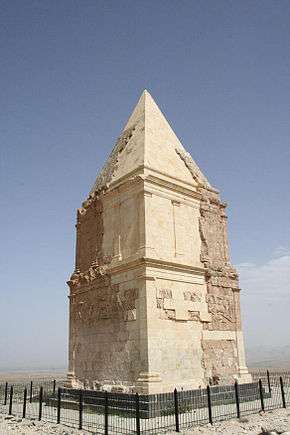
There is an ancient pyramid known as Kamouh el Hermel (Pyramid or Needle of Hermel) located about 6 kilometres (3.7 mi) south of the town that is a popular attraction for local tourists.[4]
Archaeology
Hermel plains
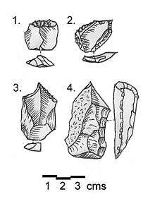
The Hermel plains are an area of low hills around Hermel, through which runs the Orontes river and several wadis, which drain into the Homs basin. The area dominates the north of the Beqaa Valley and reaches north to the border with Syria. A curious and unpublished archaeological industry exists from finds of stone tools in this area. It consists of generally small tools whose typology is limited. It was termed the Shepherd Neolithic industry by Henri Fleisch.[5]
Hermel I (Mrah Abbas)
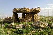
Hermel I or Mrah Abbas was discovered by P. Billaux and Maurice Tallon and is 5 kilometres (3.1 mi) north northeast of Hermel, 1 kilometre (0.62 mi) before reaching Mrah Abbas, next to the road. It is located on an uncultivated sloping plain leading down 2 kilometres (1.2 mi) from the Orontes. The garden revealed the remains of ten dolmens, most of which were built on a larger foundation than the covered chamber. Some were perhaps not covered by tumuli and a few were evidently not built to have cap-stones on top.[6]
Hermel II (Jisr el Aassi)
Hermel II or Jisr el Aassi is 2 kilometres (1.2 mi) east of Hermel I near the gorge through which the Orontes river flows. It was found by P. Billaux and mentioned by Maurice Tallon in 1958 who made a lenghy description of the largest tumulus in 1959.[7] The lithic industry at the site was discussed by Henri Fleisch in 1966.[8] Several dolmens were found around the village of Choueighir, around 1 kilometre (0.62 mi) north of the bridge over the Orontes, in and around the village extending about 2 kilometres (1.2 mi) to the north along the track next to the river. Some of the dolmen are inclined inwards forming a pyramid shape. There is a large tumulus north of the village that is composed of massive blocks where pottery was found and dated to the Early Bronze Age III by Tallon.[7] Henri Fleisch found a collection of Shepherd Neolithic flints around these dolmen.[6]
Hermel III (Choueighir)
Hermel III or Choueighir is a village on the left (western) bank of the Orontes and an archaeological site was found by P. Billaux 2 kilometres (1.2 mi) to the north of it. Flint material was described to be of the Shepherd Neolithic type and similar to that of Maakne and el Qaa by Henri Fleisch in 1966, it is held in the Museum of Lebanese Prehistory.[6]
Hermel IV (Wadi el Joz)
Hermel IV or Wadi el Joz is a collection of megaliths that are 1.5 kilometres (0.93 mi) east of Hermel Attika, southeast of Hermel on dry terraces that slope towards the channel of the Orontes. It was found by Mohammed Hamadé, surveyed by P. Billaux and published by Maurice Tallon in 1959.[7] A number of tumuli were discovered in this area which covered chambers on rectangular foundation platforms. They were usually orientated east to west with some remnants of walls constructed of megalithic stones. Maurice Tallon made collectins of flint and pottery from the area dating to various periods. These included an incised sherd and a tanged scraper from the very earliest Neolithic times, an Early Bronze Age flat scraper along with later Middle Bronze Age and Iron Age material.[6]
References
- ↑ "Hermel". Localiban.
- ↑ Our Centers
- ↑ "Car bomb blasts Lebanese town near Syria border", The Guardian, 2014-01-16
- ↑ Paul Doyle (1 March 2012). Lebanon. Bradt Travel Guides. pp. 215–. ISBN 978-1-84162-370-2. Retrieved 26 September 2012.
- ↑ Lorraine Copeland; P. Wescombe (1965). Inventory of Stone-Age sites in Lebanon, p. 43 & 45. Imprimerie Catholique. Retrieved 21 July 2011.
- 1 2 3 4 L. Copeland; P. Wescombe (1966). Inventory of Stone-Age Sites in Lebanon: North, South and East-Central Lebanon, p. 32-33. Impr. Catholique. Retrieved 3 March 2011.
- 1 2 3 Tallon, Maurice., Tumulus et Mégalithes du Hermel et de la Beqa Nord. MUSJ, vol. 31, fasc. 3, p. 91, 1959.
- ↑ Fleisch, Henri., Notes de Préhistoire Libanaise : 1) Ard es Saoude. 2) La Bekaa Nord. 3) Un polissoir en plein air. BSPF, vol. 63, 1966.
Middle Eastern megaliths | ||
|---|---|---|
| Lebanon |
|  |
| Syria | ||
| Saudi Arabia | ||
| Israel | ||
| Jordan | ||
| Turkey | ||
| Egypt | ||
| Iran | ||
| Iraq | ||
| General articles | ||