Herøyfjord
| Herøyfjorden | |
|---|---|
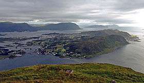 View of the fjord (background) | |
 Herøyfjorden Location in Møre og Romsdal county | |
| Location | Sunnmøre, Møre og Romsdal |
| Coordinates | 62°18′04″N 5°29′23″E / 62.3012°N 5.4897°ECoordinates: 62°18′04″N 5°29′23″E / 62.3012°N 5.4897°E |
| Basin countries | Norway |
| Max. length | 8 kilometres (5.0 mi) |
| Max. width | 2 kilometres (1.2 mi) |
| Max. depth | 175 metres (574 ft) |
The Herøyfjorden or Herøyfjord is a fjord which bisects the municipality of Herøy in Møre og Romsdal county, Norway. The fjord is about 8 kilometres (5.0 mi) long and about 2 kilometres (1.2 mi) wide, between the islands of Bergsøya and Gurskøya. The fjord has a maximum depth of 175 metres (574 ft).
The fjord has many islands located within it including Herøya and Nautøya in the east. The Flåvær islands are located in the central part of the Herøyfjorden. It is a group of islets and skerries including Flåvær, Husholmen, Torvholmen and Varholmen. The Flåvær Lighthouse is located on Varholmen.[1]
The village of Eggesbønes lies on the north shore of the fjord, just south of the town of Fosnavåg.
See also
References
- ↑ "Herøyfjord" (in Norwegian). yr.no. Retrieved 2010-09-17.
This article is issued from Wikipedia - version of the 8/18/2013. The text is available under the Creative Commons Attribution/Share Alike but additional terms may apply for the media files.