Henrietta Island
| Native name: <span class="nickname" ">Остров Генриетты | |
|---|---|
 View of the shores of Henrietta Island. | |
 Henrietta is the northernmost island of the De Long group | |
| Geography | |
| Location | Arctic Ocean |
| Coordinates | 77°06′N 156°30′E / 77.100°N 156.500°ECoordinates: 77°06′N 156°30′E / 77.100°N 156.500°E |
| Archipelago | De Long Islands |
| Area | 12 km2 (4.6 sq mi) |
| Length | 4 km (2.5 mi) |
| Width | 4 km (2.5 mi) |
| Highest elevation | 312 m (1,024 ft) |
| Highest point | Ice cap HP |
| Administration | |
|
Russia | |
| Federal Subject | Sakha Republic |
| Demographics | |
| Population | uninhabited |

Henrietta Island (Yakut: Хенриетта арыыта, Xenriyetta Aryyta, Russian: Остров Генриетты, Ostrov Genriyetty) is the northernmost island of the De Long archipelago in the East Siberian Sea. Administratively it belongs to the Sakha Republic of the Russian Federation.
Geography
Henrietta is roughly circular in shape and its diameter is about 6 km. Cape Melville (Mys Mel'villya), Henrietta's northernmost landhead, is the northernmost point of the De Long Islands, as well as the northernmost land thousands of miles east and west.[1] The closest land is Jeannette Island, located to the ESE.
Ice cap
Almost half of the island is covered by a central ice cap that reaches its maximum height at 312 m. The ice cap area has a surface of approximately 6 km² and occupies the highest south-eastern part of the island. The southern and eastern edges of the ice cap are fringed by 40 to 50 m tall icy cliffs rising above the underlying basalt plateau.
Geology
Henrietta Island consists of folded Middle Paleozoic basaltic lava and proximal volcanogenic turbidites overlain by Cenozoic clastic sedimentary rocks. The Paleozoic strata have been intruded by numerous sills, dikes, and sheets of basalts, andesite-basalts, and porphyritic diorite. The basalts and porphyritic diorite have been dated by potassium–argon dating method to be about 310-450 million years old and the porphyritic diorite has been dated by the argon–argon dating method to be about 400-440 million years old. Gritstones that are part of the Cenozoic clastic sedimentary rocks contain fragments of underlying Paleozoic strata along with significantly older gneisses, granites, quartzites, and schists.[2][3][4]
History
American explorer and US Navy lieutenant commander George Washington DeLong set out in 1879 aboard the Jeannette, hoping to reach Wrangel Island and to discover open seas in the Arctic Ocean near the North Pole. However, the ship entered an ice pack near Herald Island in September 1879 and became trapped. The vessel drifted several hundred miles with the ice, passing north of Wrangel Island. In May 1881 it approached Jeannette Island and Henrietta Island. According to The Annual Report of the Secretary of the Navy, for the Year 1882 (p. 16), "A sled party landed, hoisted the national ensign, and took possession in the name of the United States".[5][6] The excursion, led by George W. Melville, landed on June 2 or 3, constructed a cairn, and placed inside it a record of their visit.
During the 1914–1915 Imperial Russian Arctic Ocean Hydrographic Expedition led by Boris Vilkitsky, the Vaygach approached Jeannette Island with the intention of mapping Jeannette and Henrietta Islands, but heavy ice blocked the approach.[7] In 1916 the Russian ambassador in London issued an official notice to the effect that the Imperial government considered Henrietta, along with other Arctic islands, integral parts of the Russian Empire. This territorial claim was later maintained by the Soviet Union.
A Soviet polar station was established on Henrietta Island in 1937, and closed in 1963. Henrietta Island served in 1979 as the starting point for a Soviet expedition to the North Pole on skis[8]
Some U.S. individuals assert American ownership of Henrietta Island, and others of the De Long group, based on the 1881 discovery and claim. However, according to the U.S. Department of State in 2003, the U.S. government has never claimed Henrietta Island.[9]
Physical description
Henrietta Island was described by the sled party from the De Long expedition in the following terms: "The island is a desolate rock, surmounted by a snow-cap, which feeds several discharging glaciers on its east face. Dovekies nesting in the face of the rock are the only signs of game. A little moss, some grass, and a handful of rock were brought back as trophies. The cliffs are inaccessible, because of their steepness."[10]
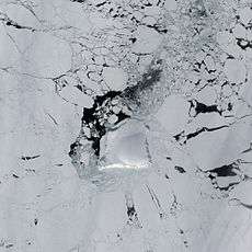 Henrietta Island as seen from space. |
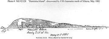 Sketch by Lt. Cmdr. George DeLong on 25 May 1881, depicting Henrietta Island, north of Siberia. |
References
- ↑ Mys Mel'villya
- ↑ Kos’ko, M.K., and G.V. Trufanov, 2002, Middle Cretaceous to Eopleistocene Sequences on the New Siberian Islands: an approach to interpret offshore seismic. Marine and Petroleum Geology. vol. 19, no. 7, pp. 901–919.
- ↑ Vinogradov, V.A., G.I. Kameneva, and G.P. Yavshits, 1975, About the Hyperborean platform in view of the new data on geological structure the Henrietta island. Arctic tectonics. vol. 1, Leningrad, USSR.
- ↑ Vinogradov V.A., E.A. Gusev, and B.G. Lopatin, 2006, Structure of the Russian Eastern Arctic Shelf in R.A. Scott and D.K. Thurston, eds., pp. 90–98, Proceedings of the Fourth International conference on Arctic margins, OCS study MMS no. 2006-003, Mineral Management Service, U.S. Department of the Interior, Anchorage, Alaska.
- ↑ Starokadomski, L.M. and O.M. Cattley, 1919, "Vilkitski's North-East Passage, 1914–15". The Geographical Journal. vol. 54, no. 6, pp. 367–375 (December 1919) (requires JSTOR access).
- ↑ Adventure Club, nd, 25 лет с Северным полюсом!, a description of the 1979 polar ski trek from the Adventure Club (Russian). Last visited May 26, 2008.
- ↑ Bureau of European and Eurasian Affairs, US State Department, 2003, Status of Wrangel and other Arctic islands Last visited May 10, 2009.
- ↑ De Long, Emma, ed., 1883, The Voyage of the Jeannette: The Ship and Ice Journals of George W. De Long, Volume II. Houghton Mifflin and Company. Last visited May 26, 2008 at the Internet Archive).
External links
- Anisimov, M.A., and V.E. Tumskoy, 2002, Environmental History of the Novosibirskie Islands for the last 12 ka. 32nd International Arctic Workshop, Program and Abstracts 2002. Institute of Arctic and Alpine Research, University of Colorado at Boulder, pp 23–25.
- Anonymous, 1923, Wrangel Island. The Geographical Journal, Vol. 62, No. 6. pp. 440–444 (Dec., 1923). (requires JSTOR access).
- Headland, R.K., 1994, OSTROVA DE-LONGA ('De Long Islands'). Scott Polar Research Institute, Cambridge University. Lasted visited May 26, 2008.
- Schirrmeister, L., H.-W. Hubberten, V. Rachold, and V.G. Grosse, 2005, Lost world - Late Quaternary environment of periglacial Arctic shelves and coastal lowlands in NE-Siberia. 2nd International Alfred Wegener Symposium Bremerhaven, October, 30 - November 2, 2005.