Hemnesberget
| Hemnesberget | |
|---|---|
| Village | |
|
View of the village | |
 Hemnesberget  Hemnesberget Location in Nordland | |
| Coordinates: 66°13′29″N 13°36′59″E / 66.22472°N 13.61639°ECoordinates: 66°13′29″N 13°36′59″E / 66.22472°N 13.61639°E | |
| Country | Norway |
| Region | Northern Norway |
| County | Nordland |
| District | Helgeland |
| Municipality | Hemnes |
| Area[1] | |
| • Total | 1.09 km2 (0.42 sq mi) |
| Elevation[2] | 39 m (128 ft) |
| Population (2013)[1] | |
| • Total | 1,300 |
| • Density | 1,193/km2 (3,090/sq mi) |
| Time zone | CET (UTC+01:00) |
| • Summer (DST) | CEST (UTC+02:00) |
| Post Code | 8640 Hemnesberget |
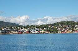
Hemnesberget is a village in the municipality of Hemnes in Nordland county, Norway. It is located on the Hemnes peninsula in the Ranfjorden.[3] The 1.09-square-kilometre (270-acre) village has a population (2013) of 1,300. The population density is 1,193 inhabitants per square kilometre (3,090/sq mi).[1] Hemnes Church is located in this village.
World War II
The village was partially destroyed in first land fighting, then by naval gunfire, with the sinking of the Hurtigruten ship SS Nordnorge and the coaster Ranheim, in the days following 10 May 1940. The fighting occurred when Hemnesberget became the objective of a German operation to bypass Allied strong points during the Norwegian Campaign, codenamed Wildente.
References
- 1 2 3 Statistisk sentralbyrå (1 January 2013). "Urban settlements. Population and area, by municipality.".
- ↑ "Hemnesberget" (in Norwegian). yr.no. Retrieved 2011-12-06.
- ↑ Store norske leksikon. "Hemnesberget" (in Norwegian). Retrieved 2011-12-06.
This article is issued from Wikipedia - version of the 7/31/2016. The text is available under the Creative Commons Attribution/Share Alike but additional terms may apply for the media files.