Port of Baltimore
| Port of Baltimore | |
|---|---|
 | |
| Details | |
| Owned by | Maryland Port Administration |
| Draft depth | 50 feet |
| Air draft | 185 feet, restricted by Francis Scott Key Bridge |
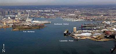
Helen Delich Bentley Port of Baltimore is a shipping port along the shores and branches of the Patapsco River in Baltimore, Maryland. The port includes facilities for cargo, especially roll-on/roll-off ships; and passenger facilities operated by the Maryland Port Administration (MPA),[1] a unit of the Maryland Department of Transportation.
The port was renamed for Helen Delich Bentley during a 2006 celebration of the port's 300th birthday.[2]
History
In 1608, Captain John Smith traveled 170 miles from Jamestown to the upper Chesapeake Bay, leading the first European expedition to the Patapsco River, named after the native Algonquians who fished shellfish and hunted.[3][4]
English land grants 1661 were combined 1702 by James Carroll who named it Whetstone Point (now known as the residential and industrial area of Locust Point). The port was founded on this site in 1706 by the Maryland Colonial Assembly as a Port of Entry for the tobacco trade with England. In 1729 the point was incorporated into BaltimoreTown.
Starting in 1776 local citizenry erected earthworks named Fort Whetstone for port defense during the American Revolutionary War, which was replaced in 1798 by Fort McHenry.[5]
Fells Point, first named Long Island Point in 1670, the deepest point in the natural harbor, soon became the colony's main ship building center, with many shipyards, famed for the construction of Baltimore clippers. These were notorious as raiders and privateers, which led to the British attack in September 1814 in the Battle of Baltimore, with the famous bombardment of Fort McHenry and land attack to the east at the Battle of North Point with fortifications also on the east side at Loudenschlager's Hill (today's Hampstead Hill/Patterson Park). Fells Point was incorporated into Baltimore Town in 1773. The Continental Navy ordered their first frigate, USS Virginia, from George Wells in Fells Point in 1775. The first ship named the USF Constellation were produced at the Harris Creek Shipyard here, and the third USS Enterprise at Henry Spencer's shipyard. Over 800 ships were commissioned from Fells Point shipyards from 1784 to 1821. The California Gold Rush lead to many orders for fast vessels; many overland pioneers also relied upon canned goods from Baltimore.[6][7]

After the founding of Baltimore the waterfront developed drydocks, warehouses, ship chandlers, as well as industry including mills were built behind the wharves. In what is now Canton, further southeast of Baltimore and Fells Point along the Patapsco River, John O'Donnell's plantation was developed in the early 1800s for worker housing and industry, including the Canton Iron Works owned by Peter Cooper and later Horace Abbott during the Civil War and others.[8]
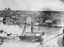
In 1828 the Baltimore and Ohio Railroad (B&O) began track laying eventually extending into Locust Point in 1845. The arrival of the Baltimore and Ohio and other railroads made the port a major transshipment point between inland points and the rest of the world.[9] By the 1840s, the Baltimore Steam Packet Company ("Old Bay Line") was providing overnight steamship service down the Chesapeake Bay.[10] After the Civil War, coffee ships were designed here for trade with Brazil. Other industrial activities in Canton included Baltimore Copper Smelting Company and small oil refineries, later purchased by Standard Oil.[11] By the end of the nineteenth century, European ship lines had terminals for emigrants from Britain, Ireland, Germany, and Poland.[9]
Harbor channels and approaches
Maintenance of harbor channels and navigation aids began early. Dredging in the harbor can be traced back as far as 1783, when the Ellicott brothers (of Ellicott Dredges) excavated the bottom at their wharf in the Inner Harbor. In 1790 the state government began systematic dredging using a "mud machine", which used a horse-drawn drag bucket, later upgraded with steam power. In 1825 Sen. Sam Smith of Maryland petitioned Congress for federal funding for this work.[12]

.jpg)
At this time Congress was smarting from the incursions of the War of 1812 and had determined to expand naval defenses. In Baltimore it led to the misconceived construction of Fort Carroll, an island three-tiered brick fortification in the 1840s (similar to various other East Coast island forts built such as the famous Fort Sumter in Charleston harbor, South Carolina), supervised by young Col. Robert E. Lee of the United States Army Corps of Engineers but federal dredging appropriations preceded that project, beginning in 1830. This first project was completed in 1838. In the 1850s a second dredging project was undertaken, this time under Capt. Henry Brewerton, who was also later in charge of the Fort Carroll project. He excavated a straight channel from Sparrows Point out to the mouth of the Patapsco near Seven Foot Knoll Light between North Point and Hawkins Point, which was erected in 1855; this channel, known today as the Brewerton Channel, continues to be the central link in the path into the harbor.
In 1865 Maj. William P. Craighill took over as Baltimore District Engineer of the Corps of Engineers. His initial survey of the Brewerton Channel disclosed severe shoaling at the mouth of the river, and he excavated a new channel starting from the older channel at a point just northwest of Seven Foot Knoll and running south to the mouth of the Magothy River, where it turned to the southsoutheast and continued to Sandy Point, just north of the present location of the Chesapeake Bay Bridge. In the 1870s a cut-off channel was dug to ameliorate the turn between the old and new channels; the Brewerton Channel was also extended to provide a connection to the Chesapeake and Delaware Canal. Enlarged and extended to access various facilities within the port, the Brewerton and Craighill Channels continue in use to the present, essentially unaltered in configuration.[13]
Federal lighthouse construction in the bay began in the 1820s, and one early project was the erecting of range lights to guide ships into the Patapsco. These lights, the North Point Range Lights, were lit in 1822, marking a path roughly the same as that of the current Craighill Cutoff Channel. Subsequent channel construction was followed shortly by light projects. Brewerton's channel was marked by the Hawkins Point and Leading Point lights, constructed in 1868 and converted to skeleton towers in 1924. The original (lower) Craighill Channel was marked with range lights in 1875, following two years of temporary lightships; the cutoff was marked with the upper range lights in 1886, replacing the North Point range, which had been discontinued in 1873. In later years a pair of skeleton towers were erected on Locust Point to mark the Fort McHenry Channel, the final leg from the end of the Brewerton Channel to Curtis Point and the Inner Harbor. All of these lights remain in use, though of course all have been automated. The Craighill Channel Lower Range Rear Light enjoys the distinction of being the tallest lighthouse in Maryland.
In 2006, then-Maryland Governor Bob Ehrlich participated in naming the port after Helen Delich Bentley during the 300th anniversary of the port.[2]
Current operations
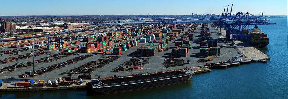
Currently the port has major roll-on roll-off (ro-ro) facilities, as well as bulk facilities, especially steel handling.[1] Most Mercedes-Benz cars that are imported into the U.S are handled here as well.[14]
During 2012, 36.7 million tons in foreign commerce (imports and exports), valued at $53.9 billion were handled by the port. This was a 2.5% decrease in tonnage from 2011. The Port of Baltimore ranked 11th of 36 USA ports in handling of foreign tonnage and 9th in dollar value of the cargo handled during 2012.[1]
In popular culture
In the 1996 action film, Eraser, the film's finale and ending battle take place on and around a Russian cargo ship in the Port of Baltimore, referred to in the movie as the "Baltimore Docks".
The second season of the HBO series The Wire centers around activity at the Port of Baltimore.
See also
Portal:Nautical
References and notes
- 1 2 3 "The Port of Baltimore's Waterbourne Commerce--2012" (PDF). Maryland Port Administration. Retrieved July 19, 2013.
- 1 2 Meredith Cohn (June 2, 2006). "Port `godmother' honored". The Baltimore Sun.
- ↑ Snell, Tee Loftin (1974). The wild shores: America's beginnings. Washington DC: National Geographic Society (U.S.), Special Publications Division. p. 84.
- ↑ "Ghosts of industrial heyday still haunt Baltimore's harbor, creeks". Chesapeake Bay Journal. Retrieved 2012-09-08.
- ↑ History of Ft. McHenry, NPS; and History of the Port of Baltimore, Port of Baltimore Tricentennial Committee.
- ↑ "Fells Point Historic district". National Park Service. Retrieved July 19, 2013.
- ↑ "Milestones in Fell's Point's History". Fell's Point Preservation Society. Retrieved July 19, 2013.
- ↑ Canton Timeline, John Cain, Canton Community Association, 2001; and Steam in Captivity, Mary Bellis, Your Guide to Inventors, c.2007.
- 1 2 "Port of Baltimore". Maryland Manual Online. Maryland State Archives. Retrieved July 18, 2013.
- ↑ "Old Bay Line". Steamboat Explorer. Retrieved July 18, 2013.
- ↑ "Neighborhood Overview". Canton Community Association. Retrieved July 18, 2013.
- ↑ Mountford, Kent (July–August 2000). "History of dredging reveals deeper need to understand Bay's bottom line". Chesapeake Bay Journal. Retrieved June 22, 2007.
- ↑ "Baltimore Harbor & Channels: History". United States Army Corps of Engineers Baltimore District. Retrieved June 22, 2007.
- ↑ Terry, Robert J. (March 22, 2004). "Mercedes hunts for port land". Baltimore Business Journal.
External links
- Maryland Port Administration - Official website
NOAA maps:
- Baltimore Harbor
- Chesapeake Bay Approaches to Baltimore Harbor
- Chapter 15 Baltimore to Head of Chesapeake Bay, Coast Pilot 3, 40th Edition, 2007, Office of Coastal Survey, NOAA.
Coordinates: 39°16′30″N 76°35′04″W / 39.275°N 76.5845°W