Heimaey
|
Heimaey in February 2009. Looking north-east | |
 | |
| Geography | |
|---|---|
| Location | Iceland |
| Coordinates | 63°26′N 20°16′W / 63.433°N 20.267°WCoordinates: 63°26′N 20°16′W / 63.433°N 20.267°W |
| Archipelago | Vestmannaeyjar |
| Total islands | 15 |
| Area | 13.4 km2 (5.2 sq mi) |
| Highest elevation | 200 m (700 ft) |
| Highest point | Helgafell |
| Administration | |
| Demographics | |
| Population | 4500 |


Heimaey (Icelandic pronunciation: [ˈheiːmaˌei]), literally Home Island, is an Icelandic island. At 13.4 square kilometres (5.2 sq mi), it is the largest island in the Vestmannaeyjar archipelago, and the largest and most populated island off the Icelandic coast. Heimaey is 4 nautical miles (7.4 km; 4.6 mi) off the south coast of Iceland. It is the only populated island of the Vestmannaeyjar islands, with a population of 4,500. The airport and the Westman Islands Golf Club cover a large part of the island.
In January 1973, lava flow from nearby Eldfell destroyed half the town and threatened to close its harbour, its main income source. An operation to cool the advancing lava with sea water saved the harbour.
History
Oldest tales
The Landnáma tells that after Ingólfur Arnarson, the first settler in Iceland, spent a winter at Ingólfshöfði, he released his Öndvegissúlur (chief's pillars) into the water and followed them west. (These were pillars associated with the chief's chair. They were put into the sea and let float to shore. Where they came ashore, the Viking who followed it would build his farm.) At Hjörleifshöfði, Ingólfur found that his brother/close friend Hjörleifr Hróðmarsson was dead and his slaves were missing. Out at sea he could see boats going toward a small group of islands, and he set off after them.
Abducted from the north of Ireland, the slaves were called westmen (Vestmenn), as before discovering Iceland, Ireland was the most western part of the world known to northern Europeans then (c. 840). The slaves went ashore at Heimaey and took shelter in the hills. Ingólfur hunted them and killed them in revenge for their murdering his foster brother. In the process, he named various places and landmarks. For example, he named "Dufþekja", an area on Heimaklettur, Heimaey's highest hill (283 m; 928 ft), after the slave Dufþakur (the Icelandic version of the Gaelic 'Dubhthach,' Anglicized as 'Duffy') who was said to have thrown himself off Heimaklettur at that point, preferring to take his own life than to let Ingólfur take it.

First settlers
In tradition, Herjólfur Bárðarson was said to be the first person to settle in Heimaey. According to the Landnáma, he built his farm in Herjólfsdalur (literally: Herjólf's valley) about 900. The archaeological excavation in 1971 of ancient ruins in Herjólfsdalur revealed that there had been settlement nearly 100 years earlier.[1]
Turkish Raid
In 1627, three Arab pirate ships from the Ottoman-controlled Barbary Coast raided several towns on the south coast of Iceland and outlying islands.[2] They attacked Grindavík and Heimaey. In Grindavík, townspeople could flee into the lava field of Reykjanes and hide indefinitely. Heimaey was so isolated that it was vulnerable and people suffered. Many heroic stories were told of the people who survived the invasion, most notably Guðríður Símonardóttir. Better known as Tyrkja-Gudda (Turkish-Gudda), she was taken by the pirates from her home at Stakkagerði on Heimaey to the slave market in Algeria. From there she bought her way back to Iceland through Tunisia, Italy and Denmark—Iceland was then under Danish rule. Upon returning to Iceland, she married the poet Hallgrímur Pétursson. The Hallgrímskirkja Lutheran church in Reykjavík is named in his honour.
Eldfell
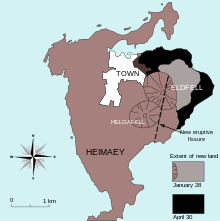
At 01:00 on 23 January 1973, a volcanic eruption of the mountain Eldfell began on Heimaey. The ground on Heimaey started to quake and fissures formed. The fissures grew to 1,600 metres (5,200 ft) in length, and lava began to erupt. Lava sprayed into the air from the fissures. Volcanic ash was blown to sea. Later, the situation deteriorated. When the fissures closed, the eruption converted to a concentrated lava flow that headed toward the harbour. The winds changed, and half a million cubic metres of ash blew on the town. During the night, the 5,000 inhabitants of the island were evacuated, mostly by fishing boats, as almost the entire fishing fleet was in dock.
The encroaching lava flow threatened to destroy the harbour. The eruption lasted until 3 July. Townspeople constantly sprayed the lava with cold seawater, causing some to solidify and much to be diverted, thus saving the harbour.[3] The people were elated that their livelihoods remained intact, even though much of their town was destroyed. During the eruption, half of the town was crushed and the island expanded in length. The eruption increased the area of Heimaey from 11.2 km2 (4.3 sq mi) to 13.44 km2 (5.19 sq mi). Only one man died in the eruption.[4][5] The eruption is described by John McPhee in his book The Control of Nature.[5]
Present day
Heimaey is home to around 4,500 people, and eight million puffins every summer.[6] Many millions of other birds migrate there for breeding and feeding.
The island is connected to the rest of Iceland by a ferry and Vestmannaeyjar Airport.
Most people on the island live off fishing. During an annual festival, people are allowed to catch a few puffins to share at the festival, or to eat at home.
In popular culture
- Some final shots of Chris Marker's film Sans Soleil are of stark white Heimaey houses slowly buried by the deep black volcanic ash of the eruption. The backdrop reveals splashes of red lava as it flows into a steel-grey sea.
- Heimaey is mentioned in the song "Island" by American progressive-metal band Mastodon. The line is "Lava goddess, Ice and fire, Settling down, Ocean Geysir, Gullfoss, Heimaey 73." This refers to the eruption of Eldfell.
- Keiko the whale from the Free Willy films was in real life flown to Klettsvik Bay on Heimaey as his final home before being freed.
- Ashes to Dust by Yrsa Sigurdardottir (2007, English Translation 2011), the third of her murder mysteries set in Iceland, is largely set on Heimaey and focuses round the Eldfell eruption of 1973, and discoveries resulting from excavation, more than 30 years later, of a house buried in the volcanic ash.
- Heimaey features in Bruce McMillan's photo-illustrated children book Nights of the Pufflings (1995). In the story a tradition of rescuing young birds, pufflings, by local children is told. The pufflings take their first flight on August nights, and get accidentally stranded in the village streets. The children then set them free at the beach at daytime.
References
- ↑ Jonsson, Sigurgeir. "About Westman Islands". Visit Westman Islands. Retrieved December 21, 2012.
- ↑ Tinniswood, Adrian (2010). Pirates of Barbary: Corsairs, Conquests and Captivity in the Seventeenth-Century Mediterranean. Penguin. ISBN 9781101445310. Retrieved 2012-12-21.
- ↑ William, Richard. "Man Against Volcano: The Eruption of Heimay, Vestmannaeyjar, Iceland (2nd Edition)" (PDF). pubs.usgs.gov. Retrieved 14 May 2016.
- ↑ http://grapevine.is/mag/articles/2014/09/26/which-way-%E2%80%A8the-wind-blows/
- 1 2 McPhee, John (1989). The Control of Nature. New York: Farrar, Straus and Giroux. ISBN 0374128901.
- ↑ Harding, Paul (2004). Iceland. Lonely Planet. p. 129.
Gallery
 Helgafell volcano
 Eldfell volcano
 View of the island
 View of the island
 View of the island
 View of the island
 Vestmannaeyjar harbour in Heimaey
External links
| Wikimedia Commons has media related to Heimaey. |
| Wikivoyage has a travel guide for Heimaey. |
- Vestmannaeyjar town council
- Travel info
- All you need to know about Westman Islands
- local newspaper
- local newspaper
- Photos from westman Islands
- photos
- VolcanoWorld page
- "Icelandic Kids Save Befuddled Puffins," National Geographic Today