Heiloo
| Heiloo | ||
|---|---|---|
| Municipality | ||
|
Heiloo town centre | ||
| ||
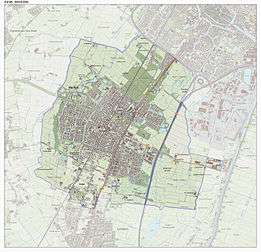
.svg.png) Location in North Holland | ||
| Coordinates: 52°36′N 4°43′E / 52.600°N 4.717°ECoordinates: 52°36′N 4°43′E / 52.600°N 4.717°E | ||
| Country | Netherlands | |
| Province | North Holland | |
| Government[1] | ||
| • Body | Municipal council | |
| • Mayor | Hans Romeyn (CDA) | |
| Area[2] | ||
| • Total | 19.01 km2 (7.34 sq mi) | |
| • Land | 18.71 km2 (7.22 sq mi) | |
| • Water | 0.30 km2 (0.12 sq mi) | |
| Elevation[3] | 3 m (10 ft) | |
| Population (May 2014)[4] | ||
| • Total | 22,620 | |
| • Density | 1,209/km2 (3,130/sq mi) | |
| Demonym(s) | Heilooënaar, Heilooër | |
| Time zone | CET (UTC+1) | |
| • Summer (DST) | CEST (UTC+2) | |
| Postcode | 1850–1852 | |
| Area code | 072 | |
| Website |
www | |

Heiloo (![]() pronunciation ) is a municipality and town in the Netherlands, in the province of North Holland. The community is part of the cooperation region Kennemerland and is located in the historical region of West Friesland. Heiloo had a population of 22,620 in 2014.
pronunciation ) is a municipality and town in the Netherlands, in the province of North Holland. The community is part of the cooperation region Kennemerland and is located in the historical region of West Friesland. Heiloo had a population of 22,620 in 2014.
Origins of the name
Heiloo (From the Dutch heilige loo, "sacred height") was given its name because Saint Willibrord was said to have performed a miracle there around 690 and created a church on a small hill.
Notable attractions
It has a town hall dating from 1926 and a church from the 12th century known as the Witte Kerk.[5] In the 1950s and 1960s the population grew quickly as many residents of Amsterdam moved to the area. Many residents work and attend school in the neighbouring city of Alkmaar.
Sporting Clubs
- FCC Boscrossers [6] - The local BMX club that has produced 5 World Champions,[7] 4 European Champions and many National Champions, the current (2013) 17-24 year old Double World Champion for 20" and Cruiser Class is Robin Van Der Kolk,[8] who won both titles in Auckland New Zealand
Local government
The municipal council of Heiloo consists of 19 seats, which are divided as follows:
- Heiloo 2000 - 5 seats
- VVD - 5 seats
- CDA - 3 seats
- PvdA - 3 seats
- GroenLinks - 2 seats
- NCPN - 1 seat
Current mayor: T.J. Romeyn (CDA)
Railway connections
Heiloo is connected to the Dutch railway network by Heiloo railway station. From this station there are many destinations available such as: Alkmaar, Hoorn, Uitgeest, Zaandam, Amsterdam, Utrecht, 's-Hertogenbosch, Eindhoven, The Hague, Weert, Roermond, Maastricht and Heerlen. For the Zaanse Schans, you should travel to Uitgeest and change onto a train to Koog-Zaandijk
There used to be a second stop on the railway line between Heiloo and Limmen. Until October 2013 it was used once a month to bring pilgrims to the nearby chapel. The name of both station and chapel is 'Onze lieve vrouwe ter nood' or 'Our Lady to Need'; the station was known as Runxputte until 1914. One of the platforms was demolished in 1997 for safety reasons.[9]
Notable residents
- Adriaan Venema (27 May 1941), journalist
- Jos Brink (1942–2007), television and theater personality
- Guus Janssen (1951), composer and pianist
- Jacques Zoon (1961), flautist
- Maarten van Roozendaal (3 May 1962), singer.
- Michael Duursma (1978), baseball player
- Twan van Steenhoven (10 August 1985), rapper, member of The Opposites
- Andy Boyd (1964) Professor London School of Economics
References
- ↑ "Samenstelling college" [Members of the board] (in Dutch). Gemeente Heiloo. Retrieved 6 March 2014.
- ↑ "Kerncijfers wijken en buurten" [Key figures for neighbourhoods]. CBS Statline (in Dutch). CBS. 2 July 2013. Retrieved 12 March 2014.
- ↑ "Postcodetool for 1851JA". Actueel Hoogtebestand Nederland (in Dutch). Het Waterschapshuis. Retrieved 6 March 2014.
- ↑ "Bevolkingsontwikkeling; regio per maand" [Population growth; regions per month]. CBS Statline (in Dutch). CBS. 26 June 2014. Retrieved 24 July 2014.
- ↑ http://www.wittekerkheiloo.nl/geschiedenis.php
- ↑ www.boscrossers.nl
- ↑ www.boscrossers.nl (2)
- ↑ http://robinvanderkolk.com/
- ↑ tijdelijke halte Onze Lieve Vrouwe ter Nood - foto's en omschrijving op stationsweb
External links
 Media related to Heiloo at Wikimedia Commons
- Official website
 |
Alkmaar | | ||
| Bergen | |
Alkmaar Castricum | ||
| ||||
| | ||||
| Castricum |
