Heidkopf (Wiehen Hills)
| Heidkopf | |
|---|---|
 Heidkopf south of Lübbecke, North Rhine-Westphalia | |
| Highest point | |
| Elevation | 273 m above sea level (896 ft) |
| Coordinates | 52°17′51″N 8°38′05″E / 52.297404°N 8.634653°ECoordinates: 52°17′51″N 8°38′05″E / 52.297404°N 8.634653°E |
| Geography | |
| Location | south of Lübbecke, North Rhine-Westphalia |
| Parent range | Wiehen Hills |
| Climbing | |
| Normal route | Fußweg |
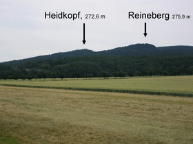
The Heidkopf is a 272.6 m high hill in the Wiehen in Minden-Lübbecke district within the borough of Lübbecke. It lies one kilometre north of the Heidbrink and 500 metres northeast of the Reineberg.
The Heidkopf is not very spectacular and is not well known even amongst the townsfolk of Lübbecke. Its summit is partly covered by old beech trees. A footpath runs from the northeast up to the summit. A metalled forest track runs around the hill. Between the Reineberg and the Heidkopf is a ravine that is still very much in a natural state, in which a stream rises, taking its source water from the Wittekind Spring.
 |
 |
Gallery
-

For years these impressive anthills have stood 100 metres north of the summit, immediately by the edge of the track
-

Only this overgrown path runs from the north to the summit
-

View of the summit. The trig point below right is about 10 metres from the top
-

The trig point on the Heidkopf