Haymarket, New South Wales
| Haymarket Sydney, New South Wales | |||||||||||||
|---|---|---|---|---|---|---|---|---|---|---|---|---|---|
 Sydney Market City building | |||||||||||||
| Population | 5,376 (2011 census)[1] | ||||||||||||
| • Density | 13,400/km2 (35,000/sq mi) | ||||||||||||
| Postcode(s) | 2000 | ||||||||||||
| Area | 0.4 km2 (0.2 sq mi) | ||||||||||||
| LGA(s) | City of Sydney | ||||||||||||
| State electorate(s) | Sydney | ||||||||||||
| Federal Division(s) | Sydney | ||||||||||||
| |||||||||||||
Haymarket is a suburb of Sydney, New South Wales, Australia. It is located at the southern end of the Sydney central business district in the local government area of the City of Sydney. Haymarket includes much of Sydney's Chinatown, Thaitown and Railway Square localities. Haymarket is adjacent to Darling Harbour and is surrounded by the suburbs of Ultimo, Chippendale, Surry Hills and the Sydney CBD.
History
Sydney's produce markets were located in Haymarket from the early 20th century through to the 1980s when they were moved to a new site at Flemington. Paddy's Markets still operate on part of the site of the vegetable markets as a produce and flea market. The 'Market City' complex contains the markets, The Peak apartment building, a modern shopping centre featuring a food court, restaurants, boutiques, specialty shops and entertainment options, such as a cinema and amusement centre.
The outer walls of the original vegetable market, built in 1909, were preserved and restored as an example of Edwardian architecture. They were part of the original city markets—designed by city architect C.Broderick—which were bounded by Hay Street, Quay Street and Thomas Street. They were built to replace the old Belmore Market, which had failed because it was too far from Darling Harbour.
The new markets included the Sydney City Markets building (Ultimo Road), designed by George McRae and built in 1910, and the Sydney Markets Bell Tower (Quay Street), built in 1911 and restored by the State Bank in 1985. The bell tower is now incorporated within the University of Technology, Sydney.[2]
The Capitol Theatre, Sydney, built in 1928, is also located in Haymarket.
Population
At the 2011 census, there were 5,376 residents in Haymarket. The median age was 27 years and 50.8% of people were aged 20–29 years. More than half of Haymarket residents were attending an educational institution, with the majority of these people attending a tertiary or technical institution. Just 10.3% of residents were born in Australia.[1] 87.8% of the population was foreign born, the highest for any Australian suburb.[3] The most common other countries of birth were China 18.3%, Thailand 14.8%, Indonesia 10.8%, Korea, Republic of (South) 7.0% and Hong Kong 2.3%. More than 80% of people spoke a language other than English at home. The top languages spoken were Mandarin 17.0%, Thai 14.4%, Indonesian 9.6%, Cantonese 7.6% and Korean 6.4%. 99.5% of dwellings were flats, units or apartments. 48.7% of households renting their accommodation were paying more than 30% of household income as rent, compared to the NSW average of 11.6% and the Australian average of 10.4.[1]
Transport
Central railway station sits on the southern border. The Sydney Entertainment Centre is located in Haymarket, between Paddy's Market and Darling Harbour. Building 5 of the University of Technology, Sydney is located in Haymarket.
Haymarket is also serviced by the Dulwich Hill Line of Sydney's light rail network with stations at Central, Capitol Square and Paddy's Markets. The light rail uses a former freight rail corridor. A short section of the corridor is not used by the light rail. This provides a pedestrian link to Railway Square and Central Station.
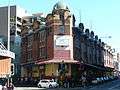 Aarons Hotel, formerly City Markets
 Vegetable market building, Hay Street
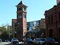 City markets bell tower, Quay Street
 Market City
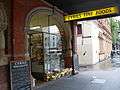 Hay St, view toward George St.
References
- 1 2 3 Australian Bureau of Statistics (31 October 2012). "Haymarket (State Suburb)". 2011 Census QuickStats. Retrieved 10 May 2013.
- ↑ Sydney Architecture, John Haskell (UNSW Press) 1997, p.55
- ↑ "Where do migrants live? (4102.0 - Australian Social Trends, 2014)". Australian Bureau of Statistics. 17 March 2014. Retrieved 20 March 2014.
External links
| Wikimedia Commons has media related to Haymarket, New South Wales. |
- Shirley Fitzgerald (2009). "Haymarket". Dictionary of Sydney. Retrieved 27 September 2015. [CC-By-SA]
- 4A Centre for Contemporary Asian Art
Coordinates: 33°52′51″S 151°12′11″E / 33.88092°S 151.20294°E