Hayden, Colorado
| Town of Hayden, Colorado | |
|---|---|
| Home Rule Municipality | |
|
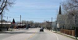
Jefferson Avenue (U.S. Route 40) in Hayden. | |
 Location in Routt County and the state of Colorado | |
| Coordinates: 40°29′34″N 107°15′19″W / 40.49278°N 107.25528°WCoordinates: 40°29′34″N 107°15′19″W / 40.49278°N 107.25528°W | |
| Country |
|
| State |
|
| County[1] | Routt |
| Established | 1894 |
| Incorporated (town) | May 5, 1906[2] |
| Government | |
| • Type | Home Rule Municipality[1] |
| Area | |
| • Total | 2.5 sq mi (6.4 km2) |
| • Land | 2.5 sq mi (6.4 km2) |
| • Water | 0 sq mi (0 km2) |
| Elevation[3] | 6,434 ft (1,961 m) |
| Population (2010) | |
| • Total | 1,810 |
| • Density | 653.6/sq mi (255.3/km2) |
| Time zone | MST (UTC-7) |
| • Summer (DST) | MDT (UTC-6) |
| ZIP code[4] | 81639 |
| Area code(s) | 970 |
| FIPS code | 08-35070 |
| GNIS feature ID | 0201992 |
| Website | Town of Hayden |
The Town of Hayden is a Home Rule Municipality in Routt County, Colorado, United States. The population was 1,634 at the 2000 census. The town sits along U.S. Highway 40 in the Yampa River Valley between Craig and Steamboat Springs. Hayden is located near the Yampa Valley Regional Airport, which has seasonal passenger jet airline service during the winter ski season nonstop to Atlanta, Chicago, Dallas/Ft. Worth, Houston, Los Angeles, Minneapolis/St. Paul and New York Newark, with year-round passenger air service to Denver. The airport's close proximity to Hayden is reflected by its three letter identifying code: HDN. Hayden is one of the smallest communities in the U.S. to have mainline passenger jet service provided by American Airlines, Delta Air Lines, and United Airlines on a scheduled basis, if only during the winter months when the ski season is underway in nearby Steamboat Springs.
History
The Ute people used the area for summer hunting before the town was settled. Trappers worked in the area in the early 1800s.[5]
The area was first settled in 1875, with the town established in 1894 and incorporated in 1906.[6] Hayden was named for F.V. Hayden, head of a survey party for the U.S. Geological & Geographic Survey in the late 1860s.[7] Hayden explored western Colorado during the late nineteenth century.
Historically a center of coal mining and agriculture,[8] it consists today of a small cluster of homes and businesses.

Geography
Hayden is located at 40°29′34″N 107°15′19″W / 40.49278°N 107.25528°W (40.492731, -107.255186).[9]
According to the United States Census Bureau, the town has a total area of 2.5 square miles (6.5 km2), all of it land.
Climate
The Town of Hayden has a Humid continental climate (Köppen climate classification Dfb), with warm summers, cold winters with heavy snow, and equal precipitation year-round. The frost-free growing season is short, averaging 93 days.[10]
| Climate data for Hayden, Colorado (1981–2010 normals) | |||||||||||||
|---|---|---|---|---|---|---|---|---|---|---|---|---|---|
| Month | Jan | Feb | Mar | Apr | May | Jun | Jul | Aug | Sep | Oct | Nov | Dec | Year |
| Record high °F (°C) | 60 (16) |
61 (16) |
75 (24) |
84 (29) |
92 (33) |
100 (38) |
100 (38) |
98 (37) |
94 (34) |
83 (28) |
74 (23) |
66 (19) |
100 (38) |
| Average high °F (°C) | 30.6 (−0.8) |
34.8 (1.6) |
46.5 (8.1) |
58.5 (14.7) |
68.7 (20.4) |
78.9 (26.1) |
85.5 (29.7) |
83.3 (28.5) |
74.6 (23.7) |
61.5 (16.4) |
44.6 (7) |
31.5 (−0.3) |
58.3 (14.6) |
| Daily mean °F (°C) | 19.4 (−7) |
23.3 (−4.8) |
34.1 (1.2) |
43.9 (6.6) |
52.8 (11.6) |
61.3 (16.3) |
67.7 (19.8) |
66.2 (19) |
57.6 (14.2) |
46.0 (7.8) |
32.5 (0.3) |
20.7 (−6.3) |
43.8 (6.6) |
| Average low °F (°C) | 8.3 (−13.2) |
11.8 (−11.2) |
21.6 (−5.8) |
29.3 (−1.5) |
37.0 (2.8) |
43.6 (6.4) |
50.0 (10) |
49.1 (9.5) |
40.6 (4.8) |
30.6 (−0.8) |
20.4 (−6.4) |
9.9 (−12.3) |
29.4 (−1.4) |
| Record low °F (°C) | −45 (−43) |
−44 (−42) |
−25 (−32) |
−5 (−21) |
15 (−9) |
21 (−6) |
27 (−3) |
28 (−2) |
7 (−14) |
−6 (−21) |
−27 (−33) |
−33 (−36) |
−45 (−43) |
| Average precipitation inches (mm) | 1.60 (40.6) |
1.33 (33.8) |
1.35 (34.3) |
1.85 (47) |
1.70 (43.2) |
1.22 (31) |
1.37 (34.8) |
1.37 (34.8) |
1.79 (45.5) |
1.72 (43.7) |
1.61 (40.9) |
1.61 (40.9) |
18.51 (470.2) |
| Average snowfall inches (cm) | 24.7 (62.7) |
18.4 (46.7) |
14.2 (36.1) |
9.7 (24.6) |
1.3 (3.3) |
Trace | 0 (0) |
0 (0) |
0.3 (0.8) |
5.5 (14) |
16.9 (42.9) |
22.6 (57.4) |
112.0 (284.5) |
| Average precipitation days (≥ 0.01 in) | 12 | 10 | 10 | 10 | 11 | 8 | 8 | 9 | 9 | 9 | 10 | 11 | 117 |
| Average snowy days (≥ 0.1 in) | 11 | 9 | 8 | 4 | 1 | 0 | 0 | 0 | 0 | 3 | 8 | 11 | 54 |
| Source: NOAA (extremes 1938–present)[11] | |||||||||||||
Demographics
| Historical population | |||
|---|---|---|---|
| Census | Pop. | %± | |
| 1910 | 314 | — | |
| 1920 | 455 | 44.9% | |
| 1930 | 554 | 21.8% | |
| 1940 | 640 | 15.5% | |
| 1950 | 767 | 19.8% | |
| 1960 | 764 | −0.4% | |
| 1970 | 763 | −0.1% | |
| 1980 | 1,720 | 125.4% | |
| 1990 | 1,444 | −16.0% | |
| 2000 | 1,634 | 13.2% | |
| 2010 | 1,810 | 10.8% | |
| Est. 2015 | 1,839 | [12] | 1.6% |
As of the census[14] of 2000, there were 1,634 people, 618 households, and 443 families residing in the town. The population density was 664.1 people per square mile (256.5/km²). There were 658 housing units at an average density of 267.4 per square mile (103.3/km²). The racial makeup of the town was 96.02% White, 0.12% African American, 0.61% Native American, 0.12% Asian, 0.06% Pacific Islander, 1.96% from other races, and 1.10% from two or more races. Hispanic or Latino of any race were 5.69% of the population.
There were 618 households out of which 42.1% had children under the age of 18 living with them, 57.1% were married couples living together, 9.4% had a female householder with no husband present, and 28.2% were non-families. 21.7% of all households were made up of individuals and 5.5% had someone living alone who was 65 years of age or older. The average household size was 2.63 and the average family size was 3.08.
In the town the population was spread out with 30.3% under the age of 18, 9.5% from 18 to 24, 33.1% from 25 to 44, 20.9% from 45 to 64, and 6.1% who were 65 years of age or older. The median age was 32 years. For every 100 females there were 104.5 males. For every 100 females age 18 and over, there were 100.2 males.
The median income for a household in the town was $42,147, and the median income for a family was $45,962. Males had a median income of $38,150 versus $23,359 for females. The per capita income for the town was $18,574. About 5.4% of families and 7.0% of the population were below the poverty line, including 8.2% of those under age 18 and 7.4% of those age 65 or over.
Notable natives and residents
- Earl Bascom, Hollywood actor, artist, sculptor, inventor, rodeo pioneer who lived and cowboyed in Hayden in the 1930s.
See also
References
- 1 2 "Active Colorado Municipalities". State of Colorado, Department of Local Affairs. Retrieved 2007-09-01.
- ↑ "Colorado Municipal Incorporations". State of Colorado, Department of Personnel & Administration, Colorado State Archives. 2004-12-01. Retrieved 2007-09-02.
- ↑ "US Board on Geographic Names". United States Geological Survey. 2007-10-25. Retrieved 2008-01-31.
- ↑ "ZIP Code Lookup" (JavaScript/HTML). United States Postal Service. Retrieved September 30, 2007.
- ↑ "History & Genealogy". www.YampaValley.infoePodunk. Retrieved July 14, 2012.
- ↑ "Hayden, Colorado". City-Data.com. Retrieved July 13, 2012.
- ↑ "Profile for Hayden, Colorado, CO". ePodunk. Retrieved July 14, 2012.
- ↑ "History & Genealogy". www.YampaValley.infoePodunk. Retrieved July 14, 2012.
- ↑ "US Gazetteer files: 2010, 2000, and 1990". United States Census Bureau. 2011-02-12. Retrieved 2011-04-23.
- ↑ Team, National Weather Service Corporate Image Web. "National Weather Service Climate". w2.weather.gov. Retrieved 2016-05-31.
- ↑ "NowData - NOAA Online Weather Data". National Oceanic and Atmospheric Administration. Retrieved May 30, 2016.
- ↑ "Annual Estimates of the Resident Population for Incorporated Places: April 1, 2010 to July 1, 2015". Retrieved July 2, 2016.
- ↑ "Census of Population and Housing". Census.gov. Retrieved June 4, 2015.
- ↑ "American FactFinder". United States Census Bureau. Retrieved 2008-01-31.
External links
Municipalities and communities of Routt County, Colorado, United States | ||
|---|---|---|
| City | 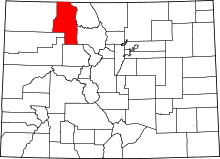 | |
| Towns | ||
| CDP | ||
| Unincorporated communities | ||
| Ghost towns | ||
