Hawera
| Hawera | |
|---|---|
|
Hawera from the Water Tower | |
 Hawera | |
| Coordinates: 39°35′36″S 174°16′42″E / 39.59333°S 174.27833°E | |
| Country | New Zealand |
| Region | Taranaki |
| District | South Taranaki District |
| Government | |
| • Mayor | Ross Dunlop |
| Population (June 2016) | |
| • Total | 11,800 |
| Postcode | 4610 |
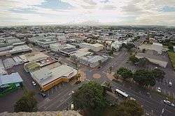
Hawera is the second-largest town in the Taranaki region of New Zealand's North Island, with a population of 11,800.[1] It is near the coast of the South Taranaki Bight.
Description
Hawera is 75 kilometres south of New Plymouth on State Highway 3 and 30 minutes' drive from Mount Taranaki. It is located on State Highway 45, known as Surf Highway 45 for its numerous surf beaches. State Highway 45 passes through Manaia, Opunake and Oakura en route to New Plymouth. Kaponga is a 20-minute drive to the north-west. The Marton–New Plymouth Line railway passes through Hawera and has served the town since 1 August 1881, though it has been freight-only since the cancellation of the last railcar passenger service between Wellington and New Plymouth on 30 July 1977.
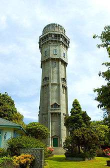
Hawera is Māori for "burnt place", from fighting between two local sub-tribes, which culminated in the setting ablaze of the sleeping whare (house) of the tribe under attack.[2] The name became apt when the town suffered extensive blazes in 1884, 1888, and 1912.[3] For this reason a large water tower was built in the centre of town to increase water pressure; and this became one of Taranaki's best-known landmarks (appearing, for example, on the cover of the 1974 telephone directory). After falling into disrepair the tower was closed to the public in 2001, but after an extensive restoration program it opened again in 2004.
Hawera is also home to Tawhiti Museum,[4] well known for its hand-crafted life-sized wax sculptures depicting scenes of local heritage and history, and its scale models of local Maori pa.[5]
Coordinates: 39°35′S 174°17′E / 39.583°S 174.283°E
Economy
The Whareroa dairy factory, 4 km south-southwest of the township, is the largest dairy complex in the world in terms of output.[6] The complex is owned by Fonterra, having been built by the former Kiwi Co-operative Dairies Limited (whose original plant opened on that site in 1975). During peak season, the complex employs 1,000 people and processes up to 14 million litres of milk per day. Electricity and heat used at Whareroa is generated by an on-site gas-fired power plant, with excess electricity fed into the national grid.[7]
Education
Hawera Primary School was established in 1875. It developed into a District High School in 1901. The current high school opened as Hawera Technical High School in 1919, and moved to its present site in 1921.[8] The intermediate school opened in 1961.[9]
The Western Institute of Technology at Taranaki has a campus in Hawera,[10] established in 1990.[11]
Hawera High School is a secondary (years 9-13) school with a roll of approximately 758. Hawera Intermediate is an intermediate (years 7-8) school with a roll of 295.[12]
Hawera Primary School, Ramanui School, Tawhiti School and Turuturu School are contributing primary (years 1-6) schools with rolls of 212, 46, 293 and 192 respectively.[12] Hawera Primary celebrated its 125th jubilee in 2000.[13] Ramanui school celebrated its 50th jubilee in 2003.[14]
Hawera Christian School and St Joseph's School are state integrated full primary (years 1-8) schools with rolls of 32 and 246 respectively.
Te Kura Kaupapa Maori o Ngati Ruanui is a full primary (years 1-8) school with a a roll of 56. It is a Kura Kaupapa Māori school which teaches in the Māori language.
All these schools are coeducational.
Born in Hawera
- Aroha Awarau (1976), award winning journalist and three time winner of the Ronald Hugh Morrieson Award. Is a senior writer at New Zealand Woman's Weekly and is a former news editor for the Woman's Day magazine.
- Michael Bent (1986), Leinster Rugby player.
- Cameron Brewer (1973), Auckland Councillor
- Alan Brough, actor, comedian, and team leader from Spicks and Specks.
- Michael Campbell (23 February 1969), professional golfer. 2005 US Open winner.
- Tim Chadwick (4 October 1962), artist & published author
- Prof Geoffrey Duncan Chisholm (1931), surgeon[15]
- Ben Hurley (1980), New Zealand comedian and 7 Days actor.
- Peter Ingram (1978), New Zealand cricket player.
- Fiona Kidman (1940), writer.
- Issac Luke (1987), New Zealand Rugby League Player.
- John Gildroy Grant (1889), World War I Victoria Cross recipient.
- Nicola Kawana (actress) roles in Shortland Street and Jackson's Wharf.
- John Mitchell (1964), rugby union player and coach.
- Ronald Hugh Morrieson (29 January 1922), author of filmed cult novels Came a Hot Friday, Pallet on the Floor, Predicament and The Scarecrow.
- Alan Stuart Paterson (1902–1968), cartoonist
- John Plumtree (16 July 1965), rugby union player and coach.
- Conrad Smith (1981), All Black rugby union player.
- Elijah Taylor (1990), New Zealand Rugby League Player.
- Adine Wilson (née Harper) (1979), Silver Ferns netballer & captain.
References
- ↑ "Subnational Population Estimates: At 30 June 2016 (provisional)". Statistics New Zealand. 21 October 2016. Retrieved 21 October 2016. For urban areas, "Subnational population estimates (UA, AU), by age and sex, at 30 June 1996, 2001, 2006-16 (2017 boundary)". Statistics New Zealand. 21 October 2016. Retrieved 21 October 2016.
- ↑ Because of differing oral traditions, translations such as "breath of fire" and "burning plains" have also been offered. See "'HAWERA' From An Encyclopaedia of New Zealand, edited by A.H. McLintock, originally published in 1966. Te Ara - The Encyclopaedia of New Zealand, updated 18 September 2007". Retrieved 2008-01-01.
- ↑ For a near-contemporary account of the damage these fires caused, see D. Nimmo Scott (c. 1895), Views of Hawera: before and after the fire, Hawera, [N.Z.]: D. Nimmo Scott; a more recent one is Arthur Fryer; Nigel Ogle (ill.) (2003), Hawera's on fire, Hawera, [N.Z.]: Hawera Historical Society. For details of Hawera's Fire Brigade, see Trevor N. Moore (1982), Hawera Fire Brigade, 1882-1982: a centennial history, Hawera, [N.Z.]: The Brigade
- ↑ For an account of the Museum by the man who built it, see Nigel Ogle (199–?), Nigel Ogle's Tawhiti Museum, Hawera, [N.Z.]: The Museum Check date values in:
|date=(help) - ↑ Perhaps Hawera's most famous example of a nineteenth-century Maori pa is the Turuturu-Mokai complex, on Turuturu Road. See John Houston (1958), Turuturu-Mokai: historic reserve near Hawera: an historical survey, Hawera, [N.Z.]: Hawera Star Print. For information upon a modern pa, see Gloria Kerehoma (1984), Commemorative centennial [i.e. centennial] booklet, 1884-1984, Hawera, [N.Z.]: Centennial Committee; Shore Print on Aotearoa Pa.
- ↑ "Largest dairy factory in the world", Te Ara
- ↑ The Whareroa Co-generation plant, www.toddenergy.co.nz
- ↑ Fryer, Arthur (1994), The Beginnings of Hawera High School, Hawera High School Jubilee Magazine, archived from the original on 14 October 2008
- ↑ School Info, Hawera Intermediate
- ↑ Campus Maps, Western Institute of Technology
- ↑ WITT History, Western Institute of Technology
- 1 2 "Directory of Schools - as at 2 August 2016". New Zealand Ministry of Education. Retrieved 2016-08-16.
- ↑ "Jubilees & reunions - Hawera Primary School", Education Gazette New Zealand, 78 (10), 14 June 1999
- ↑ "Ramanui Primary School 50th Jubilee", Education Gazette New Zealand, 82 (5), 24 March 2003
- ↑ J A Strong. "Obituary" (PDF). The Royal Society of Edinburgh.
External links
| Wikivoyage has a travel guide for Hawera. |
| Wikimedia Commons has media related to Hawera. |
- Hawera information page from the South Taranaki District Council