Haux, Pyrénées-Atlantiques
| Haux | |
|---|---|
 Haux | |
|
Location within Nouvelle-Aquitaine region  Haux | |
| Coordinates: 43°04′44″N 0°50′50″W / 43.0789°N 0.8472°WCoordinates: 43°04′44″N 0°50′50″W / 43.0789°N 0.8472°W | |
| Country | France |
| Region | Nouvelle-Aquitaine |
| Department | Pyrénées-Atlantiques |
| Arrondissement | Oloron-Sainte-Marie |
| Canton | Tardets-Sorholus |
| Intercommunality | Communauté de communes de Soule-Xiberoa |
| Government | |
| • Mayor (2008–2014) | Jean-Louis Borthelle |
| Area1 | 17.01 km2 (6.57 sq mi) |
| Population (2006)2 | 105 |
| • Density | 6.2/km2 (16/sq mi) |
| Time zone | CET (UTC+1) |
| • Summer (DST) | CEST (UTC+2) |
| INSEE/Postal code | 64258 / 64470 |
| Elevation |
266–1,385 m (873–4,544 ft) (avg. 324 m or 1,063 ft) |
|
1 French Land Register data, which excludes lakes, ponds, glaciers > 1 km² (0.386 sq mi or 247 acres) and river estuaries. 2 Population without double counting: residents of multiple communes (e.g., students and military personnel) only counted once. | |
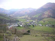
Haux (Basque: Hauze) is a commune (Verification required. The Tresorie in Tardets reports the village of Haux as part of the commune of Montory (Basque: Montori), in the Pyrénées-Atlantiques department in south-western France.
It is located in the former province of Soule.
See also
References
External links
| Wikimedia Commons has media related to Haux (Pyrénées-Atlantiques). |
Haux
This article is issued from Wikipedia - version of the 11/18/2014. The text is available under the Creative Commons Attribution/Share Alike but additional terms may apply for the media files.