Hauʻula, Hawaii
| Hauʻula Hauula | |
|---|---|
| Census-designated place | |
|
Hauʻula Elementary | |
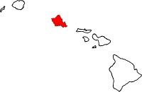
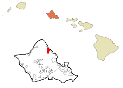 Location in Honolulu County and the state of Hawaii | |
| Coordinates: 21°36′50″N 157°54′49″W / 21.61389°N 157.91361°WCoordinates: 21°36′50″N 157°54′49″W / 21.61389°N 157.91361°W | |
| Country | United States |
| State | Hawaii |
| Area | |
| • Total | 1.9 sq mi (5.0 km2) |
| • Land | 1.2 sq mi (3.0 km2) |
| • Water | 0.8 sq mi (2.0 km2) |
| Elevation | 7 ft (2 m) |
| Population (2010) | |
| • Total | 4,148 |
| • Density | 2,100/sq mi (830/km2) |
| Time zone | Hawaii-Aleutian (UTC-10) |
| ZIP code | 96717 |
| Area code(s) | 808 |
| FIPS code | 15-12400 |
| GNIS feature ID | 0359116 |

Hauʻula is a census-designated place and rural community in the Koʻolauloa District on the island of Oʻahu, City & County of Honolulu. In Hawaiian, hauʻula means "red hau" (hau is a type of tree: Hibiscus tiliaceus). There is a small commercial center. As of the 2010 Census, the CDP population was 4,148.[1]
A fringing reef extends off the shoreline. There are several beaches and beach parks in Hauʻula, including Hauʻula Beach Park, ʻAukai Beach Park, Kokololio Beach Park, and Mahakea Beach. Sugarcane was once grown along the narrow coastal plain inland from the highway.
The U.S. postal code for Hauʻula is 96717.
There is a two-bay fire station located on Kamehameha Highway.
Geography
Hauʻula is located at 21°36′50″N 157°54′49″W / 21.61389°N 157.91361°W (21.613850, -157.913543).[2] The town is located north of Punaluʻu and south of Lāʻie along Kamehameha Highway (State Rte. 83).
According to the United States Census Bureau, Hauʻula has a total area of 1.9 square miles (5.0 km2). 1.2 square miles (3.0 km2) of it is land, and 0.77 square miles (2.0 km2) of it, or 40.56%, is water, referring to a part of the Pacific Ocean included in the census tract.[3]
Hauʻula also offers great hiking. Locals and visitors alike can enjoy the 2.5 mile Hauʻula Loop trail that wraps along the side of the mountain, providing great views of the coast and protecting reef. [4] The trail head is also shared with the Ma'akau Gulch and the Ma'akau Ridge hikes. [5]
Demographics
As of the census[6] of 2000, there were 3,651 people, 891 households, and 734 families residing in the CDP. The population density was 605.9 people per square mile (233.8/km²). There were 1,020 housing units at an average density of 169.3 per square mile (65.3/km²). The racial makeup of the CDP was 16.82% White, 0.77% African American, 0.36% Native American, 5.72% Asian, 37.44% Pacific Islander, 0.96% from other races, and 37.93% from two or more races. Hispanic or Latino of any race were 9.81% of the population.
There were 891 households out of which 45.6% had children under the age of 18 living with them, 59.6% were married couples living together, 14.6% had a female householder with no husband present, and 17.6% were non-families. 11.3% of all households were made up of individuals and 4.0% had someone living alone who was 65 years of age or older. The average household size was 4.10 and the average family size was 4.46.
In the CDP the population was spread out with 36.6% under the age of 18, 10.2% from 18 to 24, 26.6% from 25 to 44, 19.7% from 45 to 64, and 6.8% who were 65 years of age or older. The median age was 28 years. For every 100 females there were 95.3 males. For every 100 females age 18 and over, there were 94.0 males.
The median income for a household in the CDP was $38,190, and the median income for a family was $42,813. Males had a median income of $33,125 versus $24,630 for females. The per capita income for the CDP was $12,684. About 15.2% of families and 19.0% of the population were below the poverty line, including 24.0% of those under age 18 and 12.1% of those age 65 or over.
Education
Hawaii Department of Education operates public schools. Hauula Elementary School is in the CDP.[7]
References
- ↑ "Profile of General Population and Housing Characteristics: 2010 Demographic Profile Data (DP-1): Hauula CDP, Hawaii". U.S. Census Bureau, American Factfinder. Retrieved May 18, 2012.
- ↑ "US Gazetteer files: 2010, 2000, and 1990". United States Census Bureau. 2011-02-12. Retrieved 2011-04-23.
- ↑ "Geographic Identifiers: 2010 Demographic Profile Data (G001): Hauula CDP, Hawaii". U.S. Census Bureau, American Factfinder. Retrieved May 18, 2012.
- ↑ http://alltrails.com/trail/us/hawaii/hauula-loop-trail
- ↑ http://dlnr.hawaii.gov/recreation/files/2013/09/Oahu-Hiking-Map_HauulaTrailSystem.pdf
- ↑ "American FactFinder". United States Census Bureau. Retrieved 2008-01-31.
- ↑ "Hauula CDP, Hawaii." Hawaii Department of Education. Retrieved on May 21, 2009.
Islands, municipalities, and communities of Honolulu County, Hawaii, United States | ||
|---|---|---|
| CDPs |
|  |
| Unincorporated communities | ||