Harwood, Maryland
| Harwood, Maryland | |
|---|---|
| Unincorporated community | |
|
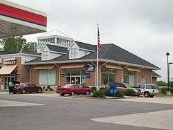
The U.S. Post Office at Harwood, Maryland, in May 2010. | |
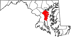
 Harwood, Maryland  Harwood, Maryland Location within the state of Maryland | |
| Coordinates: 38°51′54″N 76°37′12″W / 38.86500°N 76.62000°WCoordinates: 38°51′54″N 76°37′12″W / 38.86500°N 76.62000°W | |
| Country |
|
| State |
|
| County |
|
| Time zone | Eastern (EST) (UTC-5) |
| • Summer (DST) | EDT (UTC-4) |
| GNIS feature ID | 590432 |
Harwood is a small crossroads in Anne Arundel County, Maryland, south of Annapolis on Maryland Route 2 (Solomons Island Road).[1]
Education
Southern High School is nearby.
Historic structures
Notable people
- Thomas Noble Stockett[2]
- Joseph Noble Stockett[2]
- Stan Stearns, photographer[3]
- George Washington dined at Rawlings' Tavern.[4]
References
- ↑ U.S. Geological Survey Geographic Names Information System: Harwood, Maryland
- 1 2 3 National Park Service (2008-04-15). "National Register Information System". National Register of Historic Places. National Park Service.
- ↑ "Stan Stearns dies at 76; photographer at JFK's funeral". Los Angeles Times. Tribune Company. 4 March 2012. Retrieved 24 April 2012.
- ↑ J. J. Prats (25 October 2007). "Rawlings' Tavern Marker". The Historical Marker Database (HMdb.org). Retrieved 10 September 2013.
External links
- Harwood, MD Community Profile
- Historic places (National Register Listings)
This article is issued from Wikipedia - version of the 8/23/2016. The text is available under the Creative Commons Attribution/Share Alike but additional terms may apply for the media files.