Harvard (MBTA station)
HARVARD | |||||||||||
|---|---|---|---|---|---|---|---|---|---|---|---|
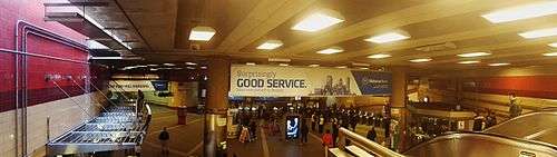
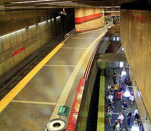 Interior of Harvard station, looking down from the secondary fare mezzanine. The outbound platform is to the left, with the inbound platform visible below to the right, and the central atrium visible in the far distance. | |||||||||||
| Location |
1400 Massachusetts Avenue Cambridge, MA 02138 | ||||||||||
| Coordinates | 42°22′24″N 71°07′09″W / 42.3734°N 71.1193°WCoordinates: 42°22′24″N 71°07′09″W / 42.3734°N 71.1193°W | ||||||||||
| Owned by | MBTA | ||||||||||
| Line(s) | |||||||||||
| Platforms | 2 Split platforms | ||||||||||
| Tracks | 2 | ||||||||||
| Construction | |||||||||||
| Bicycle facilities | 21 spaces | ||||||||||
| Disabled access | Yes | ||||||||||
| History | |||||||||||
| Opened | March 12, 1912 | ||||||||||
| Rebuilt | September 6, 1983 | ||||||||||
| Traffic | |||||||||||
| Passengers (2013) | 23,199 (weekday average boardings)[1] | ||||||||||
| Services | |||||||||||
| |||||||||||
| Location | |||||||||||
 | |||||||||||
Harvard is a rapid transit and bus transfer station on the MBTA Red Line, located at Harvard Square in Cambridge, Massachusetts. The third-busiest MBTA subway station, Harvard averaged 23,199 entries each weekday in 2013, with only Downtown Crossing and South Station handling more passengers.[1] It is also an important transfer point, with subway, bus, and trackless trolley (trolleybus) service all connecting at the station. Five of the fifteen key MBTA bus routes (with possible extended late-night service) stop at the station.
Harvard station is located directly beneath Harvard Square, a transportation, business, and cultural focal point in Cambridge. The Red Line rail platforms lie underneath Massachusetts Avenue just north of the center of the square. Many connecting surface transit routes are served by the Harvard Bus Tunnel, which descends from Mass Ave near Cambridge Street, runs southward under Harvard Square, and then westward under Brattle Street, emerging onto Mount Auburn Street. The primary station entrance leads to a central atrium fare lobby under Harvard Square; there is also a secondary fare lobby for the Red Line toward the north end of the station, with entrances at Church Street and opposite it, near Harvard's Johnston Gate; and an unpaid entrance to the bus tunnel at Brattle Square.
History
The station opened on March 23, 1912, and was completely rebuilt and relocated in the 1980s. The 1912 original entry structure was first replaced by the Harvard Square Subway Kiosk in 1928, and this later structure is now listed on the National Register of Historic Places.
The Harvard Bus Tunnel also opened in 1912, originally serving streetcars but now buses and trackless trolleys (trolleybuses). The streetcar tunnel began to be used also by the Boston-area trolleybus system in 1938, while streetcars continued to use it until 1958.[2] Diesel buses began using the tunnel in 1965.[3]
Former stations
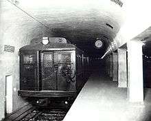
There have been a total of five stations on the Red Line in and around Harvard Square. The former Harvard station was located just east of the current station, and some remains exist; the lower level of the Harvard Bus Tunnel follows the rough curve of the old inbound platform, and preserves some of the old mosaic tiled station signs. It opened March 23, 1912, and closed January 30, 1981.[4]
The lead tracks to Eliot Street Yard (a former railcar maintenance and storage facility) curved under Harvard Square and Brattle Street, with a portal south of Bennett Street. The tunnel is still in place underground and used for MBTA storage, but the aboveground section has been demolished save for one stone marked "Boston Elevated Railway".[4] The Eliot Yard was demolished and replaced by Harvard's John F. Kennedy School of Government and the adjacent public John F. Kennedy Memorial Park in the 1980s.
"Stadium" station was located at surface level in Eliot Yard, west of the corner of what is now JFK Street and Memorial Drive. It was not open for regular use and did not have faregates; instead, employees collected fares for special service to events such as the Harvard-Yale football games (The Game).[4] It opened on October 26, 1912 and the last known use was on November 18, 1967.[5]
During the construction of the current Harvard station, two temporary stations were built. "Harvard/Brattle", a temporary station built of pressure-treated wood, consisted of two island platforms between three tracks in Eliot Yard, just outside the portal. It was open from March 24, 1979 to September 1, 1983, and was the northern terminus of the Red Line in that period.[5] The temporary station was completely demolished, and parts of the Kennedy School of Government now occupy the space.
"Harvard/Holyoke" station was located in the main Red Line tunnel east of the current station, at Massachusetts Avenue and Holyoke Street. Although it was for inbound passengers only, the temporary station was fully built with tile walls and other details. It was open from January 31, 1981, to September 1, 1983.[5] The abandoned side platform is still visible from inbound Red Line trains.
- 'Stadium' and 'Harvard/Brattle' stations
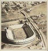 Stadium station was located in Eliot Yard, across the river from the Harvard Stadium (1915)
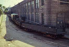 A loop track surrounded the Eliot maintenance shops (1967)
 Harvard/Brattle station occupied approximately this location (1979–1983)
 The Harvard Kennedy School of Government now occupies this site, with a concrete sign the only clue to its former use
Current station
The previous station entry building had been far too small for the volume of passenger traffic, so it was reinstalled slightly north of its original location, and repurposed as a news stand carrying local and international publications. A new modern headhouse was built south of the original location, affording a generous entry into a deep, spacious underground atrium serving as the station lobby. From this space, passengers may pass through faregates to reach new train platforms to the north. An elevator is also installed near the main entrance structure.
A new secondary fare collection mezzanine and entrances were built north of the central atrium, affording direct access to the train platforms from just outside the walled enclosure of Harvard Yard, and also across Massachusetts Avenue at the corner of Church Street.
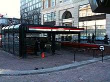
To the west of the central atrium, passengers may gain access to boarding areas for the Harvard Bus Tunnel. Near the far end of the upper bus tunnel is an exit and entry structure located in Brattle Square, including a second elevator for handicapped access to the station.
The permanent Harvard station was reopened after major reconstruction, on September 6, 1983. A bronze plaque was later installed for the formal dedication ceremony in 1985. John H. "Muggsie" Kelly, a construction foreman with the Perini Corporation, was killed when a crane fell over on May 18, 1982, during the construction of the current Harvard station. A separate memorial plaque honoring Kelly, located near Johnston Gate, was dedicated in October 1985, after the completion of the Red Line construction.[6][7]
Station layout
| G | Street Level | Exit/Entrance |
| B1 | Mezzanine | Fare mezzanine |
| B2 Upper platform level |
Outbound | ← Red Line toward Alewife (Porter) |
| Side platform, doors will open on the left | ||
| B3 Lower platform level |
Inbound | → Red Line toward Ashmont/Braintree (Central) → |
| Side platform, doors will open on the right | ||
One of the most complex subway stations of the MBTA system, Harvard has separate side platforms for rail on two levels, with outbound (northbound) trains on the upper level and inbound trains on the lower level.[4] The station is one of four stations in the MBTA system to have bi-level split platforms.[8]
Because the subway tunnel was tightly constrained to follow Massachusetts Avenue, which makes a sharp, near-right-angle turn at Harvard Square, all Red Line trains must negotiate the curve at slow speed, accompanied by loud squeals from the wheels and rails. The sharp turn is immediately at the inbound end of the station platforms.
Harvard Bus Tunnel
Off to the west of the subway platforms is the Harvard Bus Tunnel, which offers passengers underground weather-protected connections to buses and trackless trolleys. All passenger connections between rail and surface transit (even in the bus tunnel) must pass through the faregates in the central atrium, or the faregates in the secondary mezzanine.
The parallel bus tunnels serving opposite directions share common portals north and west of the station, and traverse approximately 0.25 miles (0.40 km) underground from portal to portal. The tunnels approach from the north, splitting from Massachusetts Avenue and descending through Dawes Island Park, in the median. Underground, near their closest approach to the central atrium of the station (beneath Harvard Square), the tunnels turn westward, travel beneath Brattle Square, and eventually emerge onto Mount Auburn Street.
The Harvard Bus Tunnel splits underground to a stacked configuration, with the northbound tube on top. Both bus tubes are served by side platforms, located at the southern edges of the curved tunnels. This means that passenger loading and unloading for westbound buses which lack left-side doors requires awkward passenger movements across the vehicle path, and boarding/alighting through doors facing a blank wall. Unlike the buses, MBTA trackless trolleys are specially equipped with a wide left-side door, to ease faster boarding in the tunnel.
To further expedite boarding in the tunnel, both buses and trackless trolleys allow free entry for certain routes, not collecting fares until later passenger exit from the vehicle. For security reasons, often during weekends or other low-volume periods, the lower bus tunnel is shut down and passengers must board using the upper bus tunnel, or outside the station proper. In addition, certain bus routes are not normally routed through the Harvard Bus Tunnel at any time.
The Harvard Bus Tunnel is equipped with dual overhead wires to power trackless trolleys, as well as ventilation fans to remove diesel exhaust. For safety reasons, vehicles using compressed natural gas (CNG) are banned from the tunnel, as are all non-MBTA vehicles.
Accessibility
Like all other heavy rail Red Line stations apart from Wollaston, Harvard is fully wheelchair accessible. The station features two redundant elevators for street level access (in different locations), so that either may be used while the other is out of service. Wheeled travel within the station is via wide, sweeping ramps from one level to another.
Bus connections
In the Harvard Bus Tunnel:
- 71* Watertown Square via Mt. Auburn St. (trolleybus, loads lower level except Sunday)
- 72 Huron Ave. via Concord Ave. (trolleybus, loads upper level)
- 73* Waverley Sq. via Trapelo Road (trolleybus, loads lower level except Sunday)
- 74 Belmont Center via Concord Ave. (loads upper level)
- 75 Belmont Center via Concord Ave. (loads upper level)
- 77* Arlington Heights via Massachusetts Ave. (loads upper level)
- 77A North Cambridge via Massachusetts Ave. (trolleybus, loads upper level)
- 78 Arlmont Village via Park Circle (loads upper level)
- 86 Sullivan Sq. Sta. - Reservoir (Cleveland Circle) via Harvard (traveling towards Sullivan only)
- 96 Medford Sq. via George St. & Davis Sq. Sta. (loads upper level)
On street level (outside of the underground bus terminal):
- 1* Dudley Station via Massachusetts Ave. & B.U. Medical Center
- 66* Dudley Station via Allston & Brookline Village
- 68 Kendall/M.I.T. via Broadway
- 69 Lechmere Sta. via Cambridge St.
- 86 Sullivan Sq. Sta. - Reservoir (Cleveland Circle) via Harvard (traveling towards Cleveland Circle only)
*Note: This is one of the Key MBTA bus routes (defined as the 15 busiest), which may have extended late-night service hours.
Public artwork
As a part of the Red Line Northwest Extension, Harvard was included as one of the stations involved in the pioneering Arts on the Line program. Arts on the Line was devised to bring art into the MBTA's subway stations in the late 1970s and early 1980s. It was the first program of its kind in the United States and became the model for similar arrangements to fund public art across the country.[9]
Four of the original twenty artworks are located at Harvard station.[10] The first two are located within the station interior, while the remaining two were located outdoors:
- Blue Sky on the Red Line by György Kepes — A large stained-glass wall composed of mostly cobalt blue glass, with the exception of a red band that runs the length of the work. It is mounted on the wall of the upper Harvard Bus Tunnel so that it is visible from the central atrium space of the station. <site visit>
- New England Decorative Art by Joyce Kozloff — An 83-foot (25 m) long mosaic split up into 8 sections, each resembling a quilt.
- Gateway to Knowledge by Anne Norton — A 20-foot (6.1 m) high brick structure divided vertically down the center by a gap, but still attached at the top. One half is slightly forward of the other (located in Brattle Square).
- Omphalos by Dimitri Hadzi — A freestanding grouping of pillars made up of various shapes that intersect at odd angles using many different types and polishes of granite. Previously located just north of the news stand which is also north of the main station entrance, the sculpture was removed in 2013 due to deterioration, with plans to refurbish and relocate it elsewhere. See the Arts on the Line article for further details.
Future
As a vital interchange station, Harvard is a proposed stop on the MBTA's planned Urban Ring Project.[11] The Urban Ring would be a Bus Rapid Transit (BRT) Line designed to connect the current MBTA Lines to reduce overcrowding at the downtown stations, as well as decreasing trip times.
Gallery
 A Cambridge Visitor's Information Center was installed next to the main entrance to the station
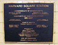 1985 dedication plaque for the new station, which had opened in 1983
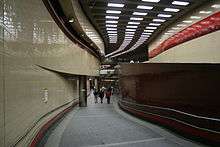 View looking northward from station atrium lobby, with outbound platform above inbound platform
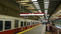 Outbound (upper) train platform, looking back south toward secondary fare mezzanine
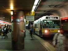
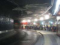 Passengers waiting in Harvard Bus Tunnel, upper level. Central atrium is visible though windows at rear.
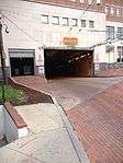 Western portal of the Harvard Bus Tunnel connects to Mount Auburn Street (behind camera viewpoint)
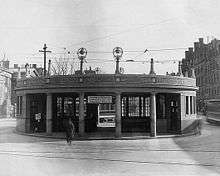 Original station headhouse of 1912
 Roof of station headhouse in 1967; this structure is now a newsstand near its original location.
References
- 1 2 "Ridership and Service Statistics" (PDF) (14 ed.). Massachusetts Bay Transportation Authority. 2014. Retrieved 26 July 2014.
- ↑ Wolinksy, Julian (Fall 1988). "Trackless But Loved in Boston". Bus World. Woodland Hills, California: Stauss Publications. pp. 6–10. ISSN 0162-9689.
- ↑ Clarke, Bradley H. (1970). The Trackless Trolleys of Boston. Boston Street Railway Association. p. 18.
- 1 2 3 4 O'Regan, Gerry. "MBTA Red Line". nycsubway.org. Retrieved 29 September 2011.
- 1 2 3 Belcher, Jonathan (20 July 2011). "Changes to Transit Service in the MBTA district" (PDF). NETransit. Retrieved 3 October 2011.
- ↑ Swartz, Steven R. (May 21, 1982). "Cause of Construction Accident Still Unknown, Investigators Say". The Harvard Crimson. Retrieved August 30, 2013.
- ↑ "Plaque in Square Honors Hardhat Killed by Crane". The Harvard Crimson. October 29, 1985. Retrieved August 30, 2013.
- ↑ The other three are Porter, State, and North Station.
- ↑ Red Line Northwest Extension Pamphlet page 5. The Davis Square Tiles Project. Accessed May 31, 2010
- ↑ Arts on the Line:Harvard Square MBTA Station. Cambridge Arts Council. 2002. Accessed May 30, 2010
- ↑ Archived July 8, 2011, at the Wayback Machine.
External links
| Wikimedia Commons has media related to Harvard (MBTA station). |
- Harvard Square Station website
- Church Street entrance (north) from Google Maps Street View
- Brattle Street entrance (south) from Google Maps Street View
| Subway lines (List of stations) |
| |||||||||||
|---|---|---|---|---|---|---|---|---|---|---|---|---|
| Commuter Rail lines (List of stations) |
| |||||||||||
| Bus routes (List of routes) | ||||||||||||
| Other services | ||||||||||||
| Component parts of system lines | ||||||||||||
| Capital projects |
| |||||||||||
| History |
| |||||||||||
| Other | ||||||||||||