Hartswater
| Hartswater | |
|---|---|
 Hartswater  Hartswater  Hartswater
| |
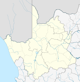
| Coordinates: 27°46′S 24°49′E / 27.767°S 24.817°ECoordinates: 27°46′S 24°49′E / 27.767°S 24.817°E | |
| Country | South Africa |
| Province | Northern Cape |
| District | Frances Baard |
| Municipality | Phokwane |
| Established | 1934 |
| Area[1] | |
| • Total | 10.77 km2 (4.16 sq mi) |
| Population (2011)[1] | |
| • Total | 10,465 |
| • Density | 970/km2 (2,500/sq mi) |
| Racial makeup (2011)[1] | |
| • Black African | 56.3% |
| • Coloured | 30.2% |
| • Indian/Asian | 0.6% |
| • White | 12.0% |
| • Other | 1.0% |
| First languages (2011)[1] | |
| • Afrikaans | 47.8% |
| • Tswana | 37.9% |
| • English | 7.8% |
| • Xhosa | 1.8% |
| • Other | 4.7% |
| Postal code (street) | 8570 |
| PO box | 8570 |
| Area code | 053 |
| Website | |
Hartswater is an agricultural town on the Phokwane River, a small tributary of the Harts River, some 23 km south of Taung and 36 km north of Warrenton. Centre of the Vaalharts Irrigation Scheme, it became a municipality in April 1960. It takes its name from the Harts River.[2]
The town was laid out in 1948. There is a monument built in the shape of a miniature church dedicated to the women of Vaalharts for their contribution towards building and developing the Vaalharts irrigation scheme located in the town of Hartswater. The town has its own wine cellar and also a newly built olive processing business.
Hartswater is centrally located to Jan Kempdorp, Pampierstad, Ganspan, Taung and Christiana.
References
- 1 2 3 4 "Main Place Hartswater". Census 2011.
- ↑ "Dictionary of Southern African Place Names (Public Domain)". Human Science Research Council. p. 200.
Municipalities and communities of Frances Baard District Municipality, Northern Cape | ||
|---|---|---|
District seat: Kimberley | ||
| Sol Plaatje | .svg.png) | |
| Phokwane | ||
| Magareng | ||
| Dikgatlong | ||
This article is issued from Wikipedia - version of the 11/25/2016. The text is available under the Creative Commons Attribution/Share Alike but additional terms may apply for the media files.