Hartbeespoort
| Hartbeespoort | |
|---|---|
 Hartbeespoort  Hartbeespoort  Hartbeespoort
| |
| Coordinates: 25°44′39″S 27°53′58″E / 25.74417°S 27.89944°ECoordinates: 25°44′39″S 27°53′58″E / 25.74417°S 27.89944°E | |
| Country | South Africa |
| Province | North West |
| District | Bojanala Platinum |
| Municipality | Madibeng |
| Area[1] | |
| • Total | 125.89 km2 (48.61 sq mi) |
| Population (2011)[1] | |
| • Total | 22,374 |
| • Density | 180/km2 (460/sq mi) |
| Racial makeup (2011)[1] | |
| • Black African | 38.2% |
| • Coloured | 1.1% |
| • Indian/Asian | 0.7% |
| • White | 59.4% |
| • Other | 0.5% |
| First languages (2011)[1] | |
| • Afrikaans | 46.5% |
| • English | 19.3% |
| • Tswana | 7.3% |
| • Tsonga | 6.2% |
| • Other | 20.7% |
| Postal code (street) | 0216 |
| PO box | 0216 |
| Area code | 012 |
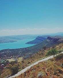
Hartbeespoort, informally also known as "Harties", is a small resort town in the North West Province of South Africa, situated on slopes of the Magaliesberg mountain and the banks of the Hartbeespoort Dam. The name of the town means "gateway of the hartbees" (a species of antelope) in Afrikaans. It was previously known as Schoemansville, named after General Hendrik Schoeman, a Boer General in the Anglo-Boer War, who owned the farm that the Hartbeespoort Dam was built on.[2]
Hartbeespoort is the collective name of a few smaller towns situated around the Hartbeespoort Dam, including the towns of Meerhof, Ifafi, Melodie, Schoemansville and Kosmos.
The town consists of holiday homes and permanent residences around the dam as it is popular with visitors from nearby Gauteng Province. It is home to the Om Die Dam (English: Around the dam) ultra marathon of 50 km, which takes place annually in the first half of the year.
Some of the main tourist attractions in or around the town are:
- The Hartbeespoort Dam wall and tunnel
- The Hartbeespoort Dam Snake Park
- The Hartbeespoort Dam Aquarium
- Hartbeespoort Aerial Cableway (the longest monocableway in Africa)[3]
- Transvaal Yacht Club
- Oberon Leisure Resort
- Welwitchia Country Market
- The Elephant Sanctuary Hartbeespoort Dam
- Bush Babies Monkey Sanctuary
- Harties horse trail safaris
- Chameleon Village
Other leisure-oriented venues around the dam include - Pecanwood Golf Estate, Hartbeespoort Boat Club (near Kosmos), Sandy Lane Golf Club (at Caribbean Beach Club), Kosmos Marina Club, Magalies Park (estate and golf club). A number of other leisure developments and resorts are in progress.
In 2010 the Hartbeespoort Aerial Cableway was completely revamped and modernised and officially reopened on 14 August 2010 by Minister of Tourism Marthinus van Schalkwyk.[4]
Hartbeespoort is part of the Madibeng Local Municipality, that also includes the nearby town of Brits.

See also
- Hartbeespoort Dam
- Hartbeespoort Aerial Cableway
- The Elephant Sanctuary Hartbeespoort Dam
- Bush Babies Monkey Sanctuary
- Lesego Holiday Home
References
- 1 2 3 4 "Main Place Hartbeespoort". Census 2011.
- ↑ Carruthers, Vincent (1990). The Magaliesberg. Johannesburg: Southern Book Publishers. p. 333.
- ↑ http://www.news24.com/Travel/South-Africa/Hartebeespoort-Cableway-reopens-20120724 News 24 Harties Cableway reopening, retrieved 19 December 2012
- ↑ http://www.info.gov.za/speech/DynamicAction?pageid=461&sid=29617&tid=78941 Government Gazette, retrieved 19 December 2012
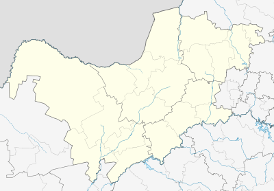
Municipalities and communities of Bojanala Platinum District Municipality, North West | ||
|---|---|---|
District seat: Rustenburg | ||
| Moretele | .svg.png) | |
| Madibeng | ||
| Rustenburg | ||
| Kgetlengrivier | ||
| Moses Kotane | ||