Harpswell, Maine
| Harpswell, Maine | |
|---|---|
| Town | |
|
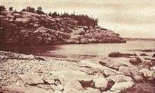
Lookout Point | |
 Location in Cumberland County and the state of Maine. | |
| Coordinates: 43°47′9″N 69°57′27″W / 43.78583°N 69.95750°WCoordinates: 43°47′9″N 69°57′27″W / 43.78583°N 69.95750°W | |
| Country | United States |
| State | Maine |
| County | Cumberland |
| Incorporated | 1758 |
| Area[1] | |
| • Total | 127.69 sq mi (330.72 km2) |
| • Land | 24.18 sq mi (62.63 km2) |
| • Water | 103.51 sq mi (268.09 km2) |
| Elevation | 39 ft (12 m) |
| Population (2010)[2] | |
| • Total | 4,740 |
| • Estimate (2012[3]) | 4,779 |
| • Density | 196.0/sq mi (75.7/km2) |
| Time zone | Eastern (EST) (UTC-5) |
| • Summer (DST) | EDT (UTC-4) |
| ZIP code | 04003, 04066, 04079 |
| Area code(s) | 207 |
| FIPS code | 23-31390 |
| GNIS feature ID | 0582511 |
| Website | www.harpswell.maine.gov |

Harpswell is a town in Cumberland County, Maine, United States, within Casco Bay in the Gulf of Maine. The population was 4,740 at the 2010 census.[4] Harpswell is composed of land contiguous with the rest of Cumberland County, called Harpswell Neck, as well as three large islands connected by bridges: Sebascodegan Island (locally known as Great Island), Orr's Island, and Bailey Island and over 200 smaller islands. Harpswell is part of the Portland–South Portland–Biddeford, Maine Metropolitan Statistical Area.
History
The Native Americans who originally inhabited Harpswell were part of the Abenaki. The Abenaki name for Harpswell Neck, then called West Harpswell, was Merriconeag or "quick carrying place", a reference to the narrow peninsula's easy portage. The Abenaki name for Great Island was Erascohegan or Sebascodiggin,[5] which became by the late 1800s Sebascodegan Island. About 1659 Major Nicholas Shapleigh of Kittery, Maine, bought Merriconeag and Sebascodegan Island from the Abenaki, but because of Indian attacks, attempts to settle the area were abandoned until after Dummer's War. The Treaty of 1725 brought a truce, and by 1731 many settlers had returned.[6]
Formerly a part of North Yarmouth, in 1758 the town was incorporated by the Massachusetts General Court and named for Harpswell in Lincolnshire, England.[7] Industries included farming and some shipbuilding, but fishing brought considerable profit, and lobstering is still a thriving part of the economy. Because of its scenic beauty, Harpswell is today a favorite with artists and tourists. The Bailey Island Bridge is an Historic Civil Engineering Landmark.
Geography
According to the United States Census Bureau, the town has a total area of 127.69 square miles (330.72 km2), of which, 24.18 square miles (62.63 km2) of it is land and 103.51 square miles (268.09 km2) is water.[1] The town is situated on Casco Bay in the Gulf of Maine, part of the Atlantic Ocean. Harpswell has about 216 miles (348 km) of coastline.[8]
The town is crossed by state routes 24 and 123. It is bordered by the town of Brunswick to the north, and is separated by the New Meadows River from West Bath to the northeast and Phippsburg to the east.
Demographics
| Historical population | |||
|---|---|---|---|
| Census | Pop. | %± | |
| 1790 | 1,071 | — | |
| 1800 | 1,049 | −2.1% | |
| 1810 | 1,190 | 13.4% | |
| 1820 | 1,253 | 5.3% | |
| 1830 | 1,352 | 7.9% | |
| 1840 | 1,448 | 7.1% | |
| 1850 | 1,534 | 5.9% | |
| 1860 | 1,603 | 4.5% | |
| 1870 | 1,749 | 9.1% | |
| 1880 | 1,773 | 1.4% | |
| 1890 | 1,766 | −0.4% | |
| 1900 | 1,750 | −0.9% | |
| 1910 | 1,650 | −5.7% | |
| 1920 | 1,242 | −24.7% | |
| 1930 | 1,364 | 9.8% | |
| 1940 | 1,305 | −4.3% | |
| 1950 | 1,644 | 26.0% | |
| 1960 | 2,032 | 23.6% | |
| 1970 | 2,552 | 25.6% | |
| 1980 | 3,796 | 48.7% | |
| 1990 | 5,012 | 32.0% | |
| 2000 | 5,239 | 4.5% | |
| 2010 | 4,740 | −9.5% | |
| Est. 2014 | 4,836 | [9] | 2.0% |

2010 census
As of the census[2] of 2010, there were 4,740 people, 2,218 households, and 1,450 families residing in the town. The population density was 196.0 inhabitants per square mile (75.7/km2). There were 4,208 housing units at an average density of 174.0 per square mile (67.2/km2). The racial makeup of the town was 97.7% White, 0.1% African American, 0.3% Native American, 0.6% Asian, 0.1% from other races, and 1.3% from two or more races. Hispanic or Latino of any race were 0.8% of the population.
There were 2,218 households of which 19.1% had children under the age of 18 living with them, 55.3% were married couples living together, 6.4% had a female householder with no husband present, 3.7% had a male householder with no wife present, and 34.6% were non-families. 27.1% of all households were made up of individuals and 12.8% had someone living alone who was 65 years of age or older. The average household size was 2.13 and the average family size was 2.53.
The median age in the town was 52.9 years. 15% of residents were under the age of 18; 4.7% were between the ages of 18 and 24; 16.9% were from 25 to 44; 37.5% were from 45 to 64; and 25.9% were 65 years of age or older. The gender makeup of the town was 48.4% male and 51.6% female.
2000 census
As of the census[11] of 2000, there were 5,239 people, 2,340 households, and 1,532 families residing in the town. The population density was 216.7 people per square mile (83.7/km²). There were 3,701 housing units at an average density of 153.1 per square mile (59.1/km²). The racial makeup of the town was 97.94% White, 0.25% African American, 0.34% Native American, 0.55% Asian, 0.23% from other races, and 0.69% from two or more races. Hispanic or Latino of any race were 1.32% of the population.
There were 2,340 households out of which 24.0% had children under the age of 18 living with them, 56.1% were married couples living together, 6.3% had a female householder with no husband present, and 34.5% were non-families. 27.3% of all households were made up of individuals and 10.9% had someone living alone who was 65 years of age or older. The average household size was 2.24 and the average family size was 2.69.
In the town the population was spread out with 19.6% under the age of 18, 4.9% from 18 to 24, 25.1% from 25 to 44, 31.7% from 45 to 64, and 18.8% who were 65 years of age or older. The median age was 45 years. For every 100 females there were 96.1 males. For every 100 females age 18 and over, there were 93.3 males.
The median income for a household in the town was $40,611, and the median income for a family was $45,119. Males had a median income of $34,167 versus $30,000 for females. The per capita income for the town was $30,433. About 3.3% of families and 5.6% of the population were below the poverty line, including 6.8% of those under age 18 and 3.8% of those age 65 or over.
Fire, EMS, Police
Fire protection services are provided in Harpswell by three unique and nonrelated volunteer fire departments. All three departments provide EMS services and operate ambulances. A town contracted paramedic is stationed 24/7 at the town hall.
- Harpswell Neck Fire Department
- Orr's and Bailey Island Fire Department
- Cundy's Harbor Fire Department
Law enforcement services are provided by the Cumberland County Sheriff's Office.
Notable people
- Patrick Dempsey, actor
- Stephen M. Etnier, artist
- Elijah Kellogg, minister, lecturer, author
- Edna St. Vincent Millay, poet[12]
- Robert P. Tristram Coffin, poet
- James L. Nelson, novelist
- Robert Peary, explorer
- Alexander Petrunkevitch, Yale professor and arachnologist
- Mark Rogers, MLB Baseball Player and National High School Player of the Year
- Jane and Steve, Internet Radio Personalities from "The Jane and Steve Comedy Show"
Education
Public schools in the area are operated by Maine School Administrative District 75. During the 2010-11 school year, Harpswell residents voted to close the West Harpswell School, one of the town's two K-5 elementary schools. Beginning in 2011-12, West Harpswell students began being bused to the Harpswell Islands School. It was due to save approximately $200,000 a year.[13] In September 2013, Harpswell Coastal Academy, a charter school serving grades 6-12 opened in the old West Harpswell School.
Sites of interest
- Eagle Island State Historic Site, summer home of Admiral Robert Peary
- Harpswell Historical Society Museum
- Ragged Island - Summer home of Edna St. Vincent Millay
References
- 1 2 "US Gazetteer files 2010". United States Census Bureau. Retrieved 2012-12-16.
- 1 2 "American FactFinder". United States Census Bureau. Retrieved 2012-12-16.
- ↑ "Population Estimates". United States Census Bureau. Retrieved 2013-07-06.
- ↑ "Profile of General Population and Housing Characteristics: 2010 Demographic Profile Data (DP-1): Harpswell town, Cumberland County, Maine". U.S. Census Bureau, American Factfinder. Retrieved June 6, 2012.
- ↑ "History of Harpswell, Maine", from A Gazetteer of the State of Maine, by Geo. J. Varney. Published by B. B. Russell, 57 Cornhill, Boston, 1886
- ↑ Coolidge, Austin J.; John B. Mansfield (1859). A History and Description of New England. Boston, Massachusetts. pp. 153–154.
- ↑ Maine League of Historical Societies and Museums (1970). Doris A. Isaacson, ed. Maine: A Guide 'Down East'. Rockland, Me: Courier-Gazette, Inc. pp. 312–316.
- ↑ Harpswell Business Association
- ↑ "Annual Estimates of the Resident Population for Incorporated Places: April 1, 2010 to July 1, 2014". Retrieved June 4, 2015.
- ↑ "Census of Population and Housing". Census.gov. Retrieved June 4, 2015.
- ↑ "American FactFinder". United States Census Bureau. Retrieved 2008-01-31.
- ↑ Milford, Nancy. Savage Beauty: The Life of Edna St. Vincent Millay. Random House, 2001. Print. p. 269
- ↑ Harpswell votes to close one of its elementary schools Portland Press Herald, 1 February 2011
Further reading
- History of Brunswick, Topsham, and Harpswell, Maine Including Ancient Pejepscot. By George Augustus Wheeler and Henry Warren Wheeler. Published 1878. Full image at books.google.
- Pejepscot Historical Society (official website)
External links
| Wikimedia Commons has media related to Harpswell, Maine. |
- Town of Harpswell official website
- Harpswell Maine Business Association
- Orr's Island Library
- Cundy's Harbor Library
- Curtis Library, Brunswick (regional library)
- Harpswell Historical Society
- Maine.gov -- Harpswell, Maine
- Maine Genealogy: Harpswell, Cumberland County, Maine
Municipalities and communities of Cumberland County, Maine, United States | ||
|---|---|---|
| Cities | 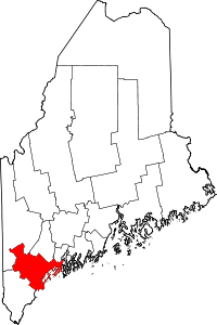 | |
| Towns | ||
| CDPs | ||
| Other villages | ||