Haridwar district
| Haridwar district हरिद्वार ज़िला | |
|---|---|
| District | |
|
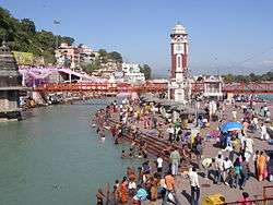
Har ki Pauri ghat in Haridwar | |
 Location in Uttarakhand, India | |
| Coordinates: 29°58′N 78°10′E / 29.96°N 78.16°ECoordinates: 29°58′N 78°10′E / 29.96°N 78.16°E | |
| Country |
|
| State | Uttarakhand |
| District | Haridwar |
| Headquarters | Haridwar |
| Area | |
| • Total | 2,360 km2 (910 sq mi) |
| Elevation | 249.7 m (819.2 ft) |
| Population (2001) | |
| • Total | 1,447,187 |
| • Density | 613/km2 (1,590/sq mi) |
| Languages | |
| • Official | Hindi |
| Time zone | IST (UTC+5:30) |
| Telephone code | 01334 |
| Vehicle registration | UK |
| Website |
haridwar |
| [1][2] | |
Haridwar district (![]() pronunciation ) also spelled as Hardwar is a district in the state of Uttarakhand, India. It is headquartered at Haridwar which is also its largest city. The district is ringed by the districts Dehradun in the north and east, Pauri Garhwal in the east and the Uttar Pradesh districts of Muzaffarnagar and Bijnor in the south and Saharanpur in the west. A paradise for nature lovers and one of the seven holiest places of Hinduism, Haridwar presents a kaleidoscope of Indian culture and civilisation.
pronunciation ) also spelled as Hardwar is a district in the state of Uttarakhand, India. It is headquartered at Haridwar which is also its largest city. The district is ringed by the districts Dehradun in the north and east, Pauri Garhwal in the east and the Uttar Pradesh districts of Muzaffarnagar and Bijnor in the south and Saharanpur in the west. A paradise for nature lovers and one of the seven holiest places of Hinduism, Haridwar presents a kaleidoscope of Indian culture and civilisation.
Haridwar district came into existence on 28 December 1988 as part of Saharanpur Divisional Commissionary,[3] On 24 September 1998 Uttar Pradesh Legislative Assembly passed the 'Uttar Pradesh Reorganisation Bill', 1998',[4] eventually the Parliament also passed the Indian Federal Legislation – 'Uttar Pradesh Reorganisation Act 2000', and thus on 9 November 2000,[5] Haridwar became part of the newly formed Uttarakhand (then Uttaranchal), the 27th state in the Republic of India.
As of 2011 it is the most populous district of Uttarakhand (out of 13).[6] Important towns in the district are Haridwar, BHEL Ranipur, Roorkee, Manglaur, Dhandera, Jhabrera, Laksar, Landhaura and Mohanpur Mohammadpur.
Geography
Haridwara district, covering an area of about 2,360 km², is in the southwestern part of Uttarakhand state of India. Its latitude and longitude are 29.96-degree north and 78.16-degree east respectively.[7]

The river Ganges flows through it in a series of channels separated from each other called aits, most of which are well wooded. Other minor seasonal streams are Ranipur Rao, Pathri Rao, Rawii Rao, Harnaui Rao, Begam Nadi etc.[8] A large part of the district is forested.
Climate
Temperatures:
- Summers: 35 °C – 42 °C
- Winters: 6 °C – 16.6 °C[9]
The district receives Monsoon rains, mostly during the summer.
Nature and wild-life
The wooded Rajaji National Park, a wildlife sanctuary, is within the bounds of the district and is accessible through different gates; Ranipur and Chilla Gates are just about 9 km from Haridwar. It is an ideal destination for wildlife and adventure lovers. Sureshvari Devi Mandir, a temple of Goddess Sureshwari, is situated in the midst of Rajaji National Park. Cheela Dam is a picnic spot with a dam and a man-made lake nearby; elephants and other wild animals could be easily spotted here. Neel Dhara Pakshi Vihar is a bird sanctuary, situated on the main Ganges river, or Neel Dhara, at the Bhimgoda Barrage; it is a paradise for bird watchers and home to many migratory birds during the winter season.[10]
Demographics
According to the 2011 census Haridwar district has a population of 1,927,029,[6] roughly equal to the nation of Lesotho[11] or the US state of West Virginia.[12] This gives it a ranking of 244th in India (out of a total of 640).[6] The district has a population density of 817 inhabitants per square kilometre (2,120/sq mi) .[6] Its population growth rate over the decade 2001–2011 was 33.16%.[6] Haridwar has a sex ratio of 879 females for every 1000 males,[6] and a literacy rate of 74.62%.[6]
Administrative background
The Haridwar district is ringed by Saharanpur in the west, Dehradun in the north west and north, Pauri Garhwal in the east, Muzaffarnagar in south and Bijnor in the south-east. Prior to its inclusion in the newly created state of Uttarakhand in 2000, this district was a part of Saharanpur Divisional Commissionary.
The district is administratively subdivided into three tehsils: Haridwar, Roorkee, and Laksar. It is further divided into six development blocks: Bhagwanpur, Roorkee, Narsan, Bahadrabad, Laksar, and Khanpur.[3][13]
The district headquarters is in Roshnabad, at a distance of about 12 km from Haridwar railway station. The office of Chief Development Officer is in Vikas Bhawan, Roshnabad. The Collectorate, Vikas Bhawan, District Judiciary, S.S.P. Office, Police line, District Jail, District sports stadium, Jawahar Navodaya Vidyalaya etc. are the prime establishments of this area. Many other administration offices like Lok Seva Ayog and Sanskrit Academy are established here.
Public representatives
The district has a single Parliament Constituency, and 11 Uttarakhand State Legislative Assembly constituencies including, Haridwar, Haridwar Rural, BHEL Ranipur, Jwalapur, Bhagwanpur, Roorkee, Piran Kaliyar, Khanpur, Manglaur Laksar and Jhabrera.[3][13][14]
Current Member of Parliament (MP) from Haridwar (Lok Sabha constituency) is Nishank Pokhriyal, and Member of Uttarakhand Legislative Assembly from Haridwar City is 'Madan Kaushik'.[14][15]
History and mythology
It is difficult to separate history from mythology and religion in the case of Haridwar.
Legends and Epics period
A glimpse of the original inhabitants of this region may be surmised from the following discourse of Bhishma Pitamah in the Vana Parva (Tirtha-yatra Parva) Section XC of The Mahabharata:[16] O! Yudhishthira, the spot where Ganga rusheth past, cleaving the foremost of mountains which is frequented by Gandharvas and Yakshas and Rakshasas and Apsaras, and inhabited by hunters, and Kinnaras, is called Gangadwara (Haridwar). O! King, Sanatkumara regardeth that spot visited by Brahmarshis, as also the Tirtha Kanakhala (that is near to it), as sacred.
According to Hindu texts, King Daksha Prajapati, father of Dakshayani (Sati), Lord Shiva's first wife, was a ruler here. He performed a yagna, to which he deliberately did not invite Lord Shiva. When he arrived uninvited, he was further insulted by the king, seeing which Sati felt infuriated and self-immolated herself in the Yagna Kund, or Sati Kund as it is called now, situated in Kankhal. The heart and navel of Sati had fallen at the place which is the present site of the Maya Devi Temple, Haridwar, dating back to the 11th century.[17] Daksha was later killed by the demon Virabhadra, born out of Shiva's anger. Subsequently, the king was brought to life and given a goat's head by Shiva.
Skanda Purana mentions a legend, in which Chanda-Munda, the Army Chief of local Demon Kings Shumbh and Nishumbha were killed here by goddess Chandi at a place, which got the name Chandi Devi Temple.[18]
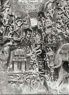
Sage Kapila had an Ashram here. The legendary King Bhagirath, the great-grandson of the Suryavanshi King Sagar, (an ancestor of Rama),[19] is said to have brought the river Ganges down from heaven, through years of penance in Satya Yuga, for the salvation of 60,000 of his ancestors from the curse of the saint Kapila.[20][21]
Lord Vishnu is said to have left his footprint on the stone that is set in the upper wall of Har-Ki-Pauri (literally, "footsteps of the Lord"), where the Holy Ganges touches it at all times. Devout Hindus perform ritualistic bathing here on the banks of the river Ganges, an act considered to be the equivalent of washing away one's sins to attain Moksha.
Seven great sages or Saptarishis, namely Kashyapa, Vashisht, Atri, Vishwamitra, Jamadagni, Bharadwaja and Gautam, are said to have meditated at the site of Sapt Rishi Ashram & Sapt Rishi Sarovar, a picturesque place near Haridwar, where the Ganges split herself into seven currents, so that the Rishis would not be disturbed by the flow.
In the Vanaparva of the Mahabharat, where sage Dhaumya tells Yudhishthira about the tirthas of India, Gangadwar, i.e. Haridwar and Kankhal, have been referred to;[22] the text also mentions that Agastya Rishi did penance here, with the help of his wife, Lopamudra (the princess of Vidharba).[23]
It is said that while Pandavas were going to Himalayas through Haridwar, prince Bhima drew water from the rocks here, by thrusting his knee (goda) into the ground at the present site of 'Bhimagoda' situated at a distance of about 1 km from Har-ki-Pauri.
Ancient period
Archaeological findings have proved that terra cotta culture dating between 1700 BCE and 1200 BCE existed in this region.[24]
Haridwar came under the rule of the Maurya Empire (322–185 BCE), and later under the Kushan Empire (c. 1st–3rd centuries).
It is believed that the sacred Ghat Har ki Pauri was constructed by King Vikramaditya (1st century BC) in memory of his brother Bharthari, who had come to Haridwar and meditated on the banks of holy Ganges and died here.
First ancient era written evidence of Haridwar is found in the accounts of a Chinese traveller, Huan Tsang, who visited India in 629 AD,[25] during the reign of King Harshavardhan (590–647). He records Haridwar as 'Mo-yu-lo', the remains of which still exist at Mayapur, a little to the south of the modern Haridwar town; among the ruins are a fort and three temples, decorated with broken stone sculptures.[26][27][28] He also mentions the presence of a temple, north of Mo-yu-lo called 'Gangadwara', Gateway of the Ganges.[27]
It is believed that Adi Shankracharya had visited this region and the existing main statue of Chandi Devi Temple was established by him in 8th century A.D.
Medieval period
Haridwar region was a part of Delhi Sultanate. The armies of Emperor Timur (1336–1405), a Turkic conqueror, had passed through this region on 13 January 1399 to attack Delhi.[29]
During his visit, first Sikh Guru, Guru Nanak (1469–1539) bathed at Haridwar's 'Kushwan Ghat', wherein the famous, 'watering the crops' episode took place.[30][31] His visit is today commemorated by a gurudwara (Gurudwara Nanakwara); according to two Sikh Janamsakhis, this visit took place on the Baisakhi day in 1504 AD. He later had also visited Kankhal en route to Kotdwara in Garhwal.[32] Besides this, third Sikh Guru, Sri Amar Das also visited Hardwar twenty two times during his lifetime.[33]
The Mughal period: Ain-e-Akbari, written by Abul Fazal in the 16th century during the reign of Mughal Emperor Akbar, refers to Maya (Mayapur), known as Hardwar on the Ganges, as sacred city of Hindus.[34] It also mentions that during his travels, and also while at home, Mughal Emperor Akbar drank water from the Ganges river, which he called 'the water of immortality'. Special people were stationed at Sorun and later Haridwar to dispatch water, in sealed jars, to wherever he was stationed.[35]
It is said that Akbar's famous Commander-in-Chief, Raja Man Singh of Amber, laid the foundation of the present day city of Haridwar and also renovated the ghats at Har-ki-pauri. After his death, his ashes are also said to have been immersed at Brahma Kund by Mughal emperor Akbar himself. Brahma Kund (literally “Brahma's reservoir”) at Har ki Pauri, Haridwar is one among the four sites where drops of the elixir of immortality, Amrita, accidentally spilled over from the pitcher, in which it was being carried away by the celestial bird Garuda, after the Samudra manthan by the Devas and the Asuras. The famous Kumbh Melas are held at these four sites in rotation, to commemorate the event. Thomas Coryat, an English traveller, who visited the city in the reign of Emperor Jahangir (1596–1627) mentions it as 'Haridwara', the capital of Shiva.[27]
British Raj
British East India Company occupied this region in 1803. One of the two major dams built by the British on the river Ganges, the 'Bhimgoda Dam', is situated here.

It was built in 1840s, to divert the waters of the Ganges, to the 'Upper Ganges Canal', which irrigated the surrounding lands. The Upper Ganges Canal was opened in 1854 after the work began in April 1842,[36] prompted by the famine of 1837–38.[36] Though beneficial for agriculture, it caused severe deterioration to the Ganges water flow, and is a major cause for the decay of the Ganges as an inland waterway, which till 18th century was used heavily by the ships of the East India Company and a town as high up as Tehri was considered a port city.[37][38] The headworks of the Ganges Canal system are located in Haridwar. The unique feature of the canal is the half-kilometre-long aqueduct over Solani river at Roorkee, which raises the canal 25 metres above the original river.
Post Independence period
In 1947, when India achieved independence from the British colonial subjugation, the region of present Haridwar district was a part of the then Saharanpur district, in the United Province of the British Raj; the province was renamed as Uttar Pradesh state of India. The Haridwar district came into existence on 28 December 1988 as part of Saharanpur Divisional Commissionary.[3] On 24 September 1998 Uttar Pradesh Legislative Assembly passed the 'Uttar Pradesh Reorganisation Bill', 1998';[4] eventually the Parliament also passed the Indian Federal Legislation – 'Uttar Pradesh Reorganisation Act, 2000' – and thus on 9 November 2000,[5] Haridwar district became part of the newly formed Uttarakhand (then Uttaranchal), the 27th state in the Republic of India.
Assembly Constituencies
- Hardwar
- B.H.E.L. Ranipur
- Jwalapur (SC)
- Bhagwanpur (SC)
- Jhabrera (SC)
- Pirankaliyar
- Roorkee
- Khanpur
- Manglaur
- Laksar
- Hardwar Rural
Economy
Agriculture is the mainstay of this well irrigated district. Industrialisation had commenced with the establishment of Central Government owned Public Sector plants (PSUs) of Hindustan Antibiotics Limited and Bharat Heavy Electricals Limited, in pre-Uttarakhand 1960s period. The State Industrial Development Corporation of Uttarakhand (SIDCUL) has now established one new 'industrial development zone' in the district, adjacent to Shivalik Nagar near Haridwar, to encourage industrialisation; with industrial giants like Hindustan Lever, Dabur, Mahendra & Mahendra and Havells having moved in, it is making the desired progress. Not insignificant to the district's economy is the contribution of Hindu pilgrims who visit the holy places and attend the religious fairs in large numbers.
Education
Haridwar district is well endowed with academic institutions of excellence, thanks mainly to the facilities of national fame available for studies in sciences, engineering, technology and advanced research in the town of Roorkee.
Education in Sanskrit based classics and Hindu religious/cultural disciplines is an age-old tradition in the district, mainly centred in and around Haridwar city. Some of the important institutions of this genre are:
- Gurukul Kangri, situated in Kankhal, on the banks of river Ganges, on Haridwar-Jwalapur bypass road. It is one of the oldest Universities of India. It was founded in 1902, to study the unique Gurukul based education system. Here Ancient Vedic and Sanskrit literature, Ayurveda, Philosophy are part of the curriculum besides modern sciences and journalism. Its 'Archaeological Museum', established in 1945,[39] houses some rare statues, coins, paintings, manuscripts and artefacts, starting from Harappa culture (c.2500–1500 BC).[40] Mahatma Gandhi visited the campus three times,[41] and stayed in its sprawling and serene campus for extended periods of time, most notably during the 1915 Kumbh mela.[42][43]
- Vishwa Sanskrit Mahavidyalaya, Haridwar. A Sanskrit University, set up by Govt. of Uttarakhand,[44] it is the only university in the world dedicated to studies of ancient Sanskrit scriptures and books. Its curriculum also covers ancient Hindu rituals, traditions and culture, and it boasts of a building inspired by ancient Hindu architecture style.
- State Ayuevedic College & Hospital Rishikul, Haridwar, is the oldest Ayurvedic Medical College of India. It is situated near Devpura in Haridwar on the banks of Upper Ganges Canal. It is also providing postgraduate education for Ayurveda. Soon it will be transformed as the first Ayuevedic University of Uttarakhand.
- Govt Ayurvedic College & Hospital, Gurukul Kangri of HNB Garhwal University is also one of the oldest Ayurvedic medical colleges in India. It is situated in Gurukul Kangri University Campus.
- Dev Sanskriti Vishwavidyalaya: established in 2002 by the act of the Uttarnchal Government is a fully residential university. Run by Sri Vedmata Gayatri Trust, Shantikunj Haridwar (headquarters of All World Gayatri Pariwar), it provides various degree, diploma and certificate courses in areas like Yogic Science, Alternative Therapy, Indian Culture, Tourism, Rural Management, Theology (Dharm Vigyan), Spiritual Counseling etc. It also provides distance learning courses.
Modern Ashrams are also being established in the district for imparting training in yoga and meditation to people coming now from near and far, including foreign countries of the West :
- Shantikunj Ashram provides a 9 days camp and one month / three months courses covering yoga, meditation, art of living, scientific spirituality etc.
Religious festivals and fairs

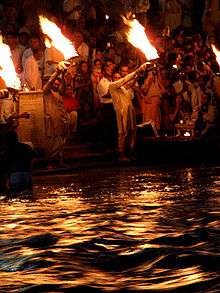
Being a place of intense religious significance, Haridwar also hosts several religious festivals throughout the year; popular among them are the Kavad Mela, Somvati Amavasya Mela, Ganga Dashara, Gughal Mela,in which around 2–2.5 million people take part.[45]
Apart from these, there is the mammoth Kumbh Mela which takes place once in every twelve years, when the planet Jupiter (Brihaspati) comes into the sign Aquarius (Kumbha). First written evidence of the Kumbha Mela can be found in the accounts of Chinese traveller Huan Tsang or Xuanzang (602 – 664 A.D.), who visited India in 629 AD.[25][46] The 1998 Maha Kumbh Mela saw over 80 million pilgrims visiting this city, to take a dip in the holy river Ganges.[47]
Places of pilgrimage
Har ki Pauri: One of the holiest spots on earth for the Hindus, this ancient bathing ghat (Steps) is of prime importance. A majority of the present ghats were largely developed in the 1800s.[48]
Sati Kund: It is the well-known mythological Sati immolation heritage situated in Kankhal.
Daksheswara Mahadev Temple: The ancient temple of Daksha Mahadev, also known as Daksheswara Mahadev Temple, is situated in the south of Kankhal town and is a tribute to the legends of Sati's self-immolated and king Daksha's death and later life with a goat's head.
Maya Devi Temple: This temple of the Adhisthatri deity of Haridwar is considered one of the Siddhapeethas and is said to be the place where the heart and navel of Goddess Sati had fallen. It is one of the few ancient temples still standing in Haridwar, along with Narayani Shila Temple and Bhairav Temple.[49]
Sapt Rishi Ashram and Sapt Rishi Sarovar, where the Ganges split herself into seven currents so that seven great sages on its bank would not be disturbed by the flow.
Bhimgoda Tank: This tank, where Bhima is said to have drawn water from the rocks by thrusting his knee into the ground, is situated at a distance of about 1 km from Har-ki-Pauri.
Chandi Devi Temple: The present temple, commemorating the ancient Chandi legend, was constructed in 1929 AD by the Dogra King of Kashmir, Suchat Singh; it can also be reached through a ropeway.
Mansa Devi Temple: The temple dedicated to Mansa Devi, a form of Shakti draws many pilgrims. There are two ways to reach the temple – trekking or it can also be reached through a ropeway.
Piran Kaliyar Sharif: This famous 'Dargah' (Shrine) of Hazrat Alauddin Sabir Kaliyari, a 13th-century Sufi Saint of Chishti Order, was built by Ibrahim Lodhi, a Delhi Sultanate ruler.[50] Also known as Sarkar Sabir Pak, it is located in Kaliyar village, 7 km from Roorkee,[51][52] and is a living example of religious harmony in India; it is visited by devotees from all over the world, during the annual 'Urs' festival, which is celebrated from 1st day (of sighting the new moon) to 16th day of Rabee-ul-awwal month of Islamic calendar.
Rama Mandir: This Rama temple is under construction at Bhupatwala and would be the biggest in size in India.
Shantikunj: Shantikunj is headquarters of spiritual and social organisation All World Gayatri Pariwar (AWGP). Founder of the organisation, Pt. Shriram Sharma Acharya, was a great saint, spiritual leader and freedom fightor. He spent last twenty years of his life here, writing literature and directing activities of the organisation. Shantikunj is considered as a place of pilgrimage by millions of devotees of this global organisation.
Transport
National Highway 58, between Delhi and Mana Pass, passes through Haridwar. Indian Railways links Haridwar Railway Station to all parts of India. The nearest airport is Jolly Grant Airport, Dehradun, though Indira Gandhi International Airport in New Delhi is preferred.
References
- ↑ http://haridwar.nic.in/history.htm#Geography
- ↑ "Haridwar District Uttarakhand, Information Updates of Haridwar District Uttarakhand Uttaranchal India". Euttaranchal.com. Retrieved 2012-08-03.
- 1 2 3 4 Geography of Haridwar
- 1 2 Reorganisation Bill passed by UP Govt The Indian Express, 24 September 1998.
- 1 2 Uttarakhand Govt. of India, Official website.
- 1 2 3 4 5 6 7 "District Census 2011". Census2011.co.in. 2011. Retrieved 2011-09-30.
- ↑ Haridwara weather and coordinates timeanddate.com/worldclock.
- ↑ City Development Plan: Haridwara Urban Development Department, Government of Uttarakhanda. p.20.
- ↑ New District Haridwar, www.gmvnl.com.
- ↑ Neel Dhara Bird Sanctuary
- ↑ US Directorate of Intelligence. "Country Comparison:Population". Retrieved 2011-10-01.
Lesotho 1,924,886
- ↑ "2010 Resident Population Data". U.S. Census Bureau. Retrieved 2011-09-30.
West Virginia 1,852,994
- 1 2 Haridwar district
- 1 2 List of Public Representatives from Haridwar Official website.
- ↑ Uttarakhand: Winners list Rediff News, 27 February 2007.
- ↑ Yudhishthira The Mahabharata, translated by Kisari Mohan Ganguli (1883 -1896), Book 3: Vana Parva: Tirtha-yatra Parva: Section XC, p 204.
- ↑ sites Uttarakhand Govt. Official website.
- ↑ Legend Chandi Devi Temple, Haridwar.
- ↑ Story of Bhagirata
- ↑ "Uttarakhand Information Centre – Gangotri Information" The Complete Uttarakhand Travel Guide
- ↑ Mankodi, Kirit (1973) "Ganga Tripathaga" Artibus Asiae 35(1/2): pp. 139–144, p. 140
- ↑ Historical, Cultural and Social Perspectives Chapter 3, The Cultural Dimension of Ecology, Baidyanath Saraswati, 1998, Indira Gandhi National Centre for the Arts. ISBN 81-246-0102-X. ignca.nic.in. Vanaparva (The Book of the Forest) is third parva (book) of Mahabharata.
- ↑ Lopamudra The Mahabharata, translated by Kisari Mohan Ganguli (1883 -1896), Book 3: Vana Parva: Tirtha-yatra Parva: Section XCVII.
- ↑ Haridwar History Haridwar Official website.
- 1 2 Kumbh Mela Channel 4.
- ↑ Haridwar
 This article incorporates text from a publication now in the public domain: Chisholm, Hugh, ed. (1911). "article name needed". Encyclopædia Britannica (11th ed.). Cambridge University Press.
 - 1 2 3 Hardwar The Imperial Gazetteer of India, v. 13, p. 52.
- ↑ Digital Library The Imperial Gazetteer of India, Oxford, 1908, Vol.13, p.51.
- ↑ History The Imperial Gazetteer of India, v. 2, p. 570.
- ↑ Guru Nanak (for Children) – A New Way of Teaching
- ↑ Life Of Guru Nanak: Chapter IV The Sikh Religion, Volume 1, by Max Arthur Macauliffe (1842–1913), Oxford University Press (1909). page 50-52.
- ↑ Janasakhi Janamsakhis of Miharban and Mani Singh, Janamsakhi Tradition, Dr. Kirpal Singh, 2004, Punjabi University, Patiala. ISBN 81-7205-311-8. www.globalsikhstudies.net.
- ↑ – Punjabkesari.
- ↑ Sacred Places of Pilgrimage Ain-e-Akbari, Vol. III, p. 306.
- ↑ Hardwar Ain-e-Akbari, by Abul Fazl 'Allami, Volume I, A´I´N 22. The A´bda´r Kha´nah. P 55. Translated from the original Persian, by Heinrich Blochmann and Colonel Henry Sullivan Jarrett, Asiatic Society of Bengal. Calcutta, 1873–1907. “His Majesty calls this source of life “the water of immortality,” and has committed the care of this department to proper persons.... Both at home and on travels, he drinks Ganges water.”
- 1 2 Upper Ganges Canal The Imperial Gazetteer of India, 1909, v. 12, p. 138.
- ↑ Gangaji Haridwar Official website of Haridwar.
- ↑ The Ganges Basin Dams on the Ganges, University at Albany.
- ↑ Archeological Museum, Haridwar indiatourism.com.
- ↑ Artefacts in the Museum Gurukul Kangri, Archaeological Museum.
- ↑ Gurukul Official website of Haridwar.
- ↑ Kumbh Mela 1915 The Story of My Experiments with Truth/Part V/Lakshman Jhula.
- ↑ Chronology of Mahatma Gandhi's life/India 1916 Wiki Source.
- ↑ Sanskrit University Govt. of Uttarakhand.
- ↑ Fairs in Haridwar Haridwar Official website.
- ↑ Kumbh Mela www.archaeologyonline.net.
- ↑ Kumbh Mela, a study Missouri State University
- ↑ Haridwar History
- ↑ Temples in Haridwar
- ↑ Piran Haridwar Official website.
- ↑ Piran Kaliyar Times of India, 13 March 2003.
- ↑ Local Attractions Roorkee
External links
| Wikimedia Commons has media related to Haridwar district. |
 |
Dehradun district | | ||
| Saharanpur district, Uttar Pradesh | |
Pauri Garhwal district | ||
| ||||
| | ||||
| Muzaffarnagar district, Uttar Pradesh | Bijnor district, Uttar Pradesh |
Further reading
- Chapter XVII: Himalayas, Hardwar. India, Past and Present, by Charles Harcourt Ainslie Forbes-Lindsay. Published by J.C. Winston, 1903.