Hares Hill Road Bridge
| Hares Hill Road Bridge over French Creek | |
|---|---|
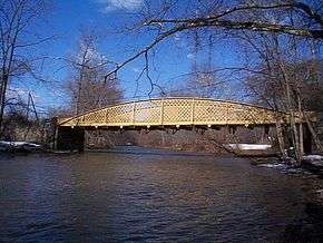 Looking upstream (northwest) | |
| Carries | Single lane of SR 1045 in Chester County |
| Crosses | French Creek |
| Locale | Kimberton, Pennsylvania, and Phoenixville, Pennsylvania |
| Official name | SR 1045 Hares Hill Bridge |
| Other name(s) | Silver Bridge |
| Maintained by | PennDOT |
| ID number | 15104500201201 |
| Characteristics | |
| Design | wrought iron through lattice girder |
| Total length | 103 ft 4 in (31.50 m) |
| Width | 14 ft (4.3 m) |
| History | |
| Opened | 1869 |
| Statistics | |
| Daily traffic | approx. 4,000 |
|
Hare's Hill Road Bridge | |
  | |
| Nearest city | Phoenixville, Pennsylvania |
| Coordinates | 40°8′28″N 75°34′4″W / 40.14111°N 75.56778°WCoordinates: 40°8′28″N 75°34′4″W / 40.14111°N 75.56778°W |
| Area | 0.2 acres (0.08 ha) |
| Built | 1867 |
| Architectural style | Bow string truss |
| NRHP Reference # | 78002375[1] |
| Added to NRHP | March 28, 1978 |
The Hares Hill Road Bridge is a single-span, wrought iron, bowstring-shaped lattice girder bridge. It was built in 1869 by Moseley Iron Bridge and Roof Company and is the only known surviving example of this kind. The bridge spans French Creek, a Pennsylvania Scenic River, and connects the village of Kimberton and Spring City in Chester County, Pennsylvania. The structure has a current load posting of 7 tons (6.4 metric tons).
Description
The Hares Hill Road Bridge superstructure consists of one 103 feet 4 inches (31.50 m) wrought-iron lattice girder span. The ends are supported on stone masonry abutments built by Abraham Taney, Jr., also in 1869. The bridge has been extensively rehabilitated several times, one of which added the current open grid steel deck.
The structure is listed in the National Register of Historic Places and has a high degree of historical and technological significance: it is the only known surviving example of Thomas William Moseley’s patented "Wrought Iron Lattice Girder Bridge." The bridge has been recorded by the Historic American Engineering Record (HAER) with detailed drawings, photographs, and a historical narrative. The structure carries one lane of traffic on Hares Hill Road (unsigned State Route 1045) across French Creek. Residences are located along the north bank of French Creek and a wooded area runs along the south bank.
The abutments are founded on rock and consist of random rubble mortared sandstone. They are 20 feet (6.1 m) long, 7 feet (2.1 m) wide at the base, have a batter of 1/2 inch per foot (1:24), and are about 12 feet (3.7 m) high above low water. Concrete pedestals have replaced the original stone-bearing seats. Wing walls extend approximately 60 feet (18 m) with a slight flare on the south side. The north wings are about 20 feet (6.1 m) long.

The original superstructure consisted of the two wrought-iron arched girders with lattice webbing and a timber floor system. The arch girders are made up of a pair of "Z"-shaped bars riveted to a central plate diaphragm. Diagonal lattice members fill the web between the upper and lower portions of the plate. Each arch has seven vertical members that support the floor system, along with the lattice and bottom tie plate. Bowstring-type tie rods extend diagonally from the bottom of the center vertical on both sides of each arch.
The HAER narrative cites three major rehabilitation campaigns before 1991.
While the bridge is currently painted yellow, it was painted silver for many years and local residents still refer to it as the "Silver Bridge."
In 2009, the Pennsylvania Department of Transportation (PennDOT) was programmed to spend $1.7 million to rehabilitate this bridge and improve its load capacity without interfering with its historical nature.[2] On June 22, 2010, the bridge was closed for rehabilitation work including replacement of the open-grid steel deck with a new deck incorporating a concrete center section for bicycle use. The $826,689 restoration was expected to last until October 2010 and raise the load restriction to 15 tons (14 metric tons).[3]
The Hares Hill Road bridge was scheduled to reopen on Friday, December 10, 2010, according to a PennDOT press release.[4]
See also

- East Pikeland Township, Pennsylvania
- Kimberton, Pennsylvania
- Zenas King
- List of bridges documented by the Historic American Engineering Record in Pennsylvania
- Moseley Wrought Iron Arch Bridge
References
- ↑ National Park Service (2009-03-13). "National Register Information System". National Register of Historic Places. National Park Service.
- ↑ "Hare's Hill Road Bridge". Retrieved 2009-07-10.
- ↑ "Hares Hill Road bridge detour starts today". Archived from the original on July 28, 2012. Retrieved 26 June 2010.
- ↑ "News for Immediate Release, "PennDOT to Reopen Historic Hares Hill Road Bridge in East Pikeland Township, Chester County on Friday."". Retrieved 8 December 2010.
External links
- Crossroads of Kimberton
- King, Allan King (June 5, 1999). Discovering Zenas King (Speech). Society for Industrial Archeology Annual Conference. Savannah, Georgia. Retrieved February 1, 2014.
- Historic American Engineering Record (HAER) No. , "Hare's Hill Road Bridge, Spanning French Creek, Kimberton, Chester County, PA"
- Hares Hill Road Bridge at Structurae
- History of Kimberton Inn
- NBI Rating