Hardenburgh, New York
| Hardenburgh, New York | |
|---|---|
| Town | |
 Location in Ulster County and the state of New York. | |
| Coordinates: 42°2′45″N 74°36′47″W / 42.04583°N 74.61306°WCoordinates: 42°2′45″N 74°36′47″W / 42.04583°N 74.61306°W | |
| Country | United States |
| State | New York |
| County | Ulster |
| Area | |
| • Total | 81.5 sq mi (211.2 km2) |
| • Land | 81.3 sq mi (210.6 km2) |
| • Water | 0.2 sq mi (0.6 km2) |
| Elevation | 2,864 ft (873 m) |
| Population (2010) | |
| • Total | 215 |
| Time zone | Eastern (EST) (UTC-5) |
| • Summer (DST) | EDT (UTC-4) |
| FIPS code | 36-32116 |
| GNIS feature ID | 0979046 |
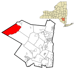
Hardenburgh is a town located in the western part of Ulster County, New York, United States. The population was 215 at the 2010 census. The town is located inside the Catskill Park.
History
Hardenburgh was established in 1859 from the Towns of Denning and Shandaken. The town was named for Johannes Hardenbergh, a landowner and patentee.[1][2]
Between 1976 and 1983, 236 residents became ministers of the Universal Life Church, for taxation purposes.[3][4]
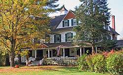
The Balsam Lake Mountain Fire Observation Station, Coykendall Lodge, and Grant Mills Covered Bridge are listed on the National Register of Historic Places.[5]
Geography
According to the United States Census Bureau, the Town has a total area of 81.5 square miles (211 km2), of which, 81.3 square miles (211 km2) of it is land and 0.2 square miles (0.52 km2) of it (0.28%) is water.
Hardenburgh sits in the western corner of the county, bordering Sullivan and Delaware counties, deep in the Catskill Mountains. Five of the Catskill High Peaks are within or along its borders.
Because of the mountains, the only direct route from Hardenburgh to the rest of the county are hiking trails over them. Any vehicular traffic must go through either Sullivan or Delaware counties.
One of those lesser mountains, Dry Brook Ridge, effectively divides the town as well. The portion north of it, in the Dry Brook valley, uses the ZIP code and telephone exchange of the nearby Delaware County hamlet of Arkville. The portion to the south, containing the headwaters of the famous Beaver Kill trout stream, is likewise oriented to the Sullivan County hamlet of Lew Beach to its south, although it contains a few of its own unique toponyms such as Turnwood, its only real road junction.
Alder Lake, a 45-acre lake made in the 1900s, is also located in the town.
Demographics
| Historical population | |||
|---|---|---|---|
| Census | Pop. | %± | |
| 1860 | 505 | — | |
| 1870 | 628 | 24.4% | |
| 1880 | 801 | 27.5% | |
| 1890 | 784 | −2.1% | |
| 1900 | 722 | −7.9% | |
| 1910 | 598 | −17.2% | |
| 1920 | 420 | −29.8% | |
| 1930 | 313 | −25.5% | |
| 1940 | 326 | 4.2% | |
| 1950 | 284 | −12.9% | |
| 1960 | 252 | −11.3% | |
| 1970 | 239 | −5.2% | |
| 1980 | 280 | 17.2% | |
| 1990 | 204 | −27.1% | |
| 2000 | 208 | 2.0% | |
| 2010 | 238 | 14.4% | |
| Est. 2014 | 231 | [6] | −2.9% |
As of the census[8] of 2000, there were 208 people, 95 households, and 57 families residing in the town. The population density was 2.6 people per square mile (1.0/km²). There were 275 housing units at an average density of 3.4 per square mile (1.3/km²). The racial makeup of the town was 96.15% White, 0.48% African American, 2.40% Asian, 0.96% from other races. Hispanic or Latino of any race were 0.96% of the population.
There were 95 households out of which 20.0% had children under the age of 18 living with them, 51.6% were married couples living together, 4.2% had a female householder with no husband present, and 40.0% were non-families. 35.8% of all households were made up of individuals and 15.8% had someone living alone who was 65 years of age or older. The average household size was 2.09 and the average family size was 2.70.
In the town the population was spread out with 15.4% under the age of 18, 5.3% from 18 to 24, 26.4% from 25 to 44, 33.2% from 45 to 64, and 19.7% who were 65 years of age or older. The median age was 47 years. For every 100 females there were 105.9 males. For every 100 females age 18 and over, there were 109.5 males.
The median income for a household in the town was $35,278, and the median income for a family was $41,250. Males had a median income of $27,083 versus $21,389 for females. The per capita income for the town was $19,184. About 12.3% of families and 13.2% of the population were below the poverty line, including 3.3% of those under the age of eighteen and 14.9% of those sixty five or over.
Communities and locations in Hardenburgh
- Beaver Kill – A stream in the south part of the town.
- Belle Ayre (or "Belleayre") – A hamlet located in the northwest part of the town.
- Hardenburgh – A hamlet located in the south part of the town next to Beaver Kill.
- Mapledale – A hamlet in the northwest part of the town.
- Seager – A hamlet located in the southeast part of the town.
- Turnwood – A hamlet located in the western end of the town, located on Beaver Kill and Route 54.
References
- ↑ "Profile for Hardenburgh, New York". ePodunk. Retrieved 2010-04-27.
- ↑ Gannett, Henry (1905). The Origin of Certain Place Names in the United States. Govt. Print. Off. p. 149.
- ↑ Amy Wallace; David Wallechinsky; Irving Wallace, eds. (1983). The People's almanac presents the book of lists #3 (Bantam ed.). New York: Bantam. p. 314. ISBN 0553278681.
- ↑ "More local tax problems". The Post-Crescent. Appleton, Wisconsin. 24 Sep 1976. p. 41 – via newspapers.com.
- ↑ National Park Service (2010-07-09). "National Register Information System". National Register of Historic Places. National Park Service.
- ↑ "Annual Estimates of the Resident Population for Incorporated Places: April 1, 2010 to July 1, 2014". Retrieved June 4, 2015.
- ↑ "Census of Population and Housing". Census.gov. Retrieved June 4, 2015.
- ↑ "American FactFinder". United States Census Bureau. Retrieved 2008-01-31.
External links
| Wikimedia Commons has media related to Hardenburgh, New York. |
Municipalities and communities of Ulster County, New York, United States | ||
|---|---|---|
| City | 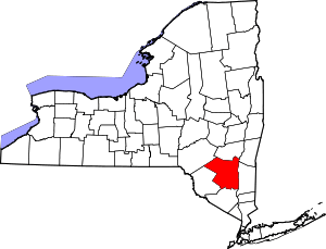 | |
| Towns | ||
| Villages | ||
| CDPs |
| |
| Other hamlets | ||
| Footnotes | ‡This populated place also has portions in an adjacent county or counties | |