Harbor Gateway, Los Angeles
| Harbor Gateway | |
|---|---|
| Neighborhood of Los Angeles | |
|
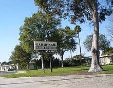
Harbor Gateway neighborhood sign | |
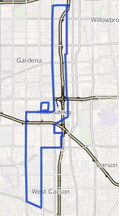 Harbor Gateway as outlined by the Los Angeles Times | |
 Los Angeles County with the City of Los Angeles in red. The Harbor Gateway is a two-mile wide north-south corridor that connects the Port of Los Angeles to the south with the rest of the city in the north (note the vertical red line). | |
| Coordinates: 33°51′00″N 118°17′57″W / 33.850072°N 118.299068°W |

The Harbor Gateway is a 5.14-square-mile, shoelace-shaped north-south residential and industrial neighborhood in the Los Angeles, California, Harbor Region, in the southern part of the city. It is highly diverse ethnically, and has experienced a measure of hostilities between blacks and Latinos, and a gang injunction has been enforced against Latino gangs.
Harbor Gateway was originally known as the Shoestring Strip and was attached to Los Angeles in 1906 to serve as a link to the Pacific Ocean port cities of Wilmington and San Pedro. It was given its present name in 1985.
With a relatively youthful population of 42,000+, it is the home of Gardena High School and seven other schools. The neighborhood is bisected by Artesia Boulevard and has two neighborhood councils, one north of the boulevard and the other south of it. A large transportation center serves the south Los Angeles County area.
Geography
Harbor Gateway is a narrow north-south corridor situated approximately between Vermont Avenue and Figueroa Street north of Interstate 405, and Western and Normandie avenues south of I-405. The territory was acquired by the city of Los Angeles in a shoestring annexation, specifically to connect San Pedro, Wilmington, Harbor City and the Port of Los Angeles with the rest of the city.
Despite being part of the city of Los Angeles, some parts of Harbor Gateway have a "Torrance, CA", "Gardena, CA" or "Carson, CA" address because they are serviced by those cities' post offices.
Harbor Gateway abuts Broadway-Manchester on the north and is flanked by Rosewood, Carson and West Carson to the east, West Carson and Harbor City to the south and Athens and Gardena to the west and Torrance to the south and west.[1][2]
The neighborhood's street boundaries are 120th Street on the north and Vermont Avenue and Figueroa Street on the west and east respectively, running south to 182nd Street, where the neighborhood takes a jog to the west and draws its western boundary at Western Avenue, its eastern line at Normandie Avenue and its southern border at West Sepulveda Boulevard. A southeastern section bounded by 192nd Street on the north, Hamilton Avenue on the east, Del Amo Boulevard on the south and railroad tracks on the west includes the Holiday Inn Harbor Gateway.[2][3]
Another section between 177th and 182nd Streets includes Gardena High School.[2]
Adjacent neighborhoods
Relation of Harbor Gateway to other communities, not necessarily contiguous:[2][3][4]
 |
Inglewood | Vermont Vista | Green Meadows and Watts | |
| Athens, Gardena and Torrance | |
Rosewood, Carson and West Carson | ||
| ||||
| | ||||
| West Carson, Harbor City and Torrance |
Population
A total of 39,688 people lived in Harbor Gateway's 5.14 square miles, according to the 2000 U.S. census—averaging 7,720 people per square mile, about the same population density for the city as a whole. Population was estimated at 42,005 in 2008. The median age was 27, young for the city of Los Angeles. The percentage of married women (56.2%) was among the county's highest.[3]
Harbor Gateway is considered highly diverse ethnically, with a diversity index of 0.648[5] In 2000 Latinos made up 53.4% of the population, blacks were at 16.3%, Asians at 16%, whites at 11.8% and others at 2.4%. Mexico and the Philippines were the most common places of birth for the 40.8% of the residents who were born abroad, considered an average percentage of foreign-born when compared with the city as a whole.[3]
The $47,849 median household income in 2008 dollars was average for the city. Renters occupied 59.7% of the housing units, and homeowners occupied the rest.[3]
In 1992 it was noted that the poorest part of the area was between Rosecrans Avenue and Artesia Boulevard.[6]
History
The city of Los Angeles annexed the area on December 26, 1906 "in anticipation of taking over, several years later, the independent cities of Wilmington and San Pedro" in order to create the Port of Los Angeles. Because of its slim shape, once likened to two shoelaces tied together with a granny knot,[7] the neighborhood—only a half mile wide at some points—was known for years as the "city strip," the "shoestring strip" or simply "the strip."[8]
The strip was simply open fields before World War II, but "Then came factories, attracting workers who needed housing," and builders "filled those fields with small houses and duplexes." Cubans settled in the 1960s and Mexican immigrants in the 1970s. From 1985 to 1992 some seventy-five single-family homes were replaced by nearly five hundred apartment units, and the neighborhood gained some 1,500 residents, with "no plan, no thought," as the area's leading developer put it.[9]
A Latino gang, the 204th Street Gang, came into existence, but as the African-American population rose from 313 in 1990 to 835 in 2000, a black gang also formed—the 208th Street Crips. "The Crip gang's willingness to go to the police with complaints offended the Latino gang's sense of honor," wrote reporter Sam Quinones for the Los Angeles Times. Yet the gang was never "rooted in the neighborhood," and by 2001 it had faded away.[9]
In 1985, the Los Angeles City Council renamed the area as Harbor Gateway.[8][10] But a Los Angeles Times reporter noted four years later that
Harbor Gateway lacks much of what makes a community a community—no central business district, no civic center or gathering place, no library branch, no police station . . . no post office. Its largest park is a cemetery. And, despite the new name, mailing addresses of residents remain unchanged. They still say Torrance or Gardena, not Los Angeles.[8]
In 1989, however, Harbor Gateway was tied with the Westwood neighborhood as Los Angeles's second-fastest-growing area, Sylmar being first. But the contrast between the unkempt Los Angeles side of Gardena Boulevard and the tidy Gardena side was striking. In March 1988, the United Way of Los Angeles declared Harbor Gateway an "under-served geographic area," noting "real gaps in law enforcement" and in social services. At the same time, there became a "major drawing card for commercial development" along the 190th Street corridor where "Gleaming high-rises with pleasant landscaping have replaced a Shell oil refinery and manufacturing plants."[8]
In 1985, Harbor Gateway was referred to as a "crime-plagued area," and residents blamed the widespread availability of alcohol for "dozens of robberies, burglaries and other crimes" in the blue-collar neighborhood. There were at that time 51 liquor outlets within a two-mile radius of the intersection of El Segundo Boulevard and Vermont Avenue.[11]
By 1992, the United Way had "funneled $100,000 to the few private charities serving the area, including a small free medical clinic, a job center and an ad hoc coalition helping the homeless." It was written that "extended families crowd into single apartments, and the homeless sleep under freeway overpasses."[6]
In 2013, it was noted that one section of Harbor Gateway had "one of the city's highest concentrations of registered sex offenders," with 86 living in a 13-block area, and so the city began a campaign to force some of them to move by building pocket parks in Harbor Gateway and in Wilmington. In California, such offenders are barred by law from living near schools and parks. The small park was built on city-owned land on the southeast corner of Torrance Boulevard and Denker Avenue.[12]
Other than the notorious 204th street gang, Gardena 13 has also been taking over the Gardena strip of Harbor Gateway. Known for violent acts of crimes, Gardena Police Dept. formed an 18-month investigation which led to the arrest of 11 suspects, one individual being that of a triple murder incident. Harbor Gateway's Gardena Boulevard is heart of this gang. On the corner of Ainsworth and Gardena a mural of the Virgin Mary has expressed the Chicano culture.
Racial violence
In 1991, parts of the Gateway were known to be "the turf of warring black and Latino gangs, and Gardena High School students of those two ethnicities "clashed after a multicultural program in the school auditorium."[6] In December 2006 the Los Angeles Times reported that racial tensions "have held this working-class neighborhood in a state of fear for years" and that the Latino 204th Street Gang, "noted for preying on" blacks had warned all blacks to stay south of 206th Street.[13] The neighborhood averaged "about one Latino-on-black homicide" each year since 1997, the Los Angeles Police Department reported.[14]
In 1997, police, the county Human Relations Commission and neighbors organized to fight the gang and the blight. The city added bulletproof streetlight covers. Residents repaired holes in fences -- escape routes for gang members. Girl Scouts, accompanied by officers, picked up trash and painted over graffiti. More than 100 gang members -- black and Latino -- were sent to jail for parole or probation violations. Police patrols increased. Violence fell. But the campaign dissipated, and gang members slowly returned. By 1999, the Latino-on-black violence resumed.[9]
In December 2006, a 14-year-old black girl, Cheryl Green, was shot and killed while talking with friends on Harvard Boulevard just south of the 206th Street dividing line. Jonathan Fajardo, 18, was sentenced to death for killing Green and for stabbing a "potential witness" to death.[13] Another culprit, Ernesto Alvarez, was sentenced to a range of 238 years to life in state prison for the acting as a lookout in Cheryl's death.[14]
A 2008, gang injunction put many Latino gang members in jail,[14] and by 2009, racial tensions had "definitely calmed," and a new community center was opened at 1435 Del Amo Boulevard in the city of Torrance and named in honor of Cheryl Green. "Cheryl's death was the tipping point for L.A.," said Los Angeles Councilwoman Janice Hahn, yet gang graffiti still abounded in the neighborhood and blacks were fearful of Latino animosity.[15][16]
Government and infrastructure
The Los Angeles County Department of Health Services operates the Torrance Health Center in Harbor Gateway, near Torrance.[17]
The National Transportation Safety Board operates the Gardena Aviation Field Office in Harbor Gateway; it is the regional headquarters of the NTSB Aviation Western Region.[18]
The area is served by two neighborhood councils—Harbor Gateway North and Harbor Gateway South, with the division between the two at Artesia Boulevard.[19][20]
Economy
Many trucking, shipping and logistics companies are based in Harbor Gateway.[7] The headquarters of National Stores (Fallas Paredes) is in Harbor Gateway, near Gardena.[21] Yoshinoya America's headquarters are in Harbor Gateway, near Torrance.[22]
Roosevelt Memorial Park is a cemetery between Vermont and Normandie north of 184th Street.[2]
Education
Just 12.4% of Harbor Gateway's residents aged 25 or older had completed a four-year degree by 2000, an average figure when compared with the city at large. The percentage of residents of that age without a high school diploma was high for the county.[3]
Schools
The schools within Harbor Gateway's boundaries are:[23]
- Gardena High School, LAUSD,1301 West 182nd Street
- Moneta Continuation School, LAUSD, 1230 West 177th Street
- Magnolia Science Academy Santa Clara, LAUSD charter, no address given
- One Hundred Thirty-Fifth Street Elementary School, LAUSD, 801 West 135th Street
- Gardena Elementary School, LAUSD, 647 West Gardena Boulevard
- Gardena Valley Christian School, private, 1473 West 182nd Street
- One Hundred Eighty-Sixth Street Elementary School, LAUSD, 1581 West 186th Street. In 2011, the school was one of only three in the Los Angeles Unified School District where bus transportation was provided "solely because of safety concerns." Otherwise, Harbor Gateway pupils would "have to cross railroad tracks and major freeway onramps and offramps" to get to their school. The community, it was said, was also home to "dozens of paroled sex offenders."[24]
- Halldale Elementary School, LAUSD, 21514 Halldale Avenue
Libraries
Los Angeles Public Library operates the Harbor Gateway-Harbor City Branch.[25]
Recreation and parks
The Rosecrans Recreation Center/CVS Playground is in Harbor Gateway, on Vermont Avenue south of 149th Street.[2] The playground was developed by the nonprofit Boundless Playgrounds.[26]
Public transportation
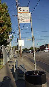
The Harbor Gateway Transit Center is a big transportation hub for various bus lines. The Metro Silver Line bus rapid transit line runs between El Monte Station, Downtown Los Angeles and the Harbor Gateway Transit Center and select trips to San Pedro, which is the line's southern terminus. The Metro Silver Line operates on the Harbor Transitway (I-110 freeway) between Downtown Los Angeles, the Harbor Gateway Transit Center and San Pedro. The Harbor Gateway Transit Center is located at 731 W. 182nd Street, Gardena, CA 90248. Nine Metro bus lines (including the Metro Silver Line) operate to various destinations from the transit center. In addition, Torrance Transit lines 1, 4, and 6 serve the transit center, while the Carson Circuit operates North / South Shuttle which serves the transit center as well. Additionally, Gardena Transit lines 2, 4and 6 also stop at the transit center.
See also
References
- ↑ "Harbor," Mapping L.A., Los Angeles Times
- 1 2 3 4 5 6 The Thomas Guide, Los Angeles County 2006, pages D, 704, 734, 764 and 794
- 1 2 3 4 5 6 "Harbor Gateway," Mapping L.A., Los Angeles Times
- ↑ "Harbor," Mapping L.A., Los Angeles Times
- ↑ "Diversity," Mapping L.A., Los Angeles Times
- 1 2 3 Ronald B. Taylor, "Stretched Thin: Public Services: Harbor Gateway, an Eight-Mile Ribbon of Los Angeles, Is Long on Need and Short on Government Support," Los Angeles Times, April 30, 1992
- 1 2 "Council District 15: Harbor Gateway, the City on a Shoestring," Los Angeles Times, December 23, 2011
- 1 2 3 4 Sheryl Stolberg, "In Search of an Identity: Area Lacks a Sense of Community," Los Angeles Times, January 1, 1989 (three screens)
- 1 2 3 Sam Quinones, "How a Community Imploded," Los Angeles Times, March 4, 2007
- ↑ See, for example, Leonard Pitt and Dale Pitt, "Shoestring Strip," Los Angeles From A to Z, University of California Press (1997) ISBN 0520202740.
- ↑ David Ferrell, "Harbor Gateway Residents Win Round in Alcohol Sales Battle," Los Angeles Times, August 25, 1985
- ↑ Angel Jennings, "L.A. Sees Parks as a Weapon Against Sex Offenders," Los Angeles Times, February 28, 2013
- 1 2 Victoria Kim, "Death Penalty Ordered for Two in Harbor Gateway," Los Angeles Times, September 28, 2010
- 1 2 3 Sam Quinones, "Man Gets 238 Years in L.A. Hate-Crime Slaying of Teenage Girl," Los Angeles Times, June 22, 2012
- ↑ Ari B. Bloomekatz, "Youth Center Opens as Racial Tensions Ease in Harbor Gateway," Los Angeles Times, June 18, 2009
- ↑ Boys and Girls Clubs of the South Bay
- ↑ "Torrance Health Center." Los Angeles County Department of Health Services. Retrieved on March 18, 2010.
- ↑ "Regional Offices: Aviation." National Transportation Safety Board. Retrieved on May 15, 2010.
- ↑ Harbor Gateway North map
- ↑ Harbor Gateway South map
- ↑ "Contact Us." National Stores. Retrieved on February 24, 2010.
- ↑ "Company Contact Information." Yoshinoya America. Retrieved on February 25, 2010.
- ↑ "Harbor Gateway, Schools," Mapping L.A., Los Angeles Times
- ↑ Carla Rivera, "Many Factors Contribute to Success at LAUSD's 186th Street Elementary," Los Angeles Times, October 23, 2011
- ↑ Harbor City-Harbor Gateway Los Angeles Public Library
- ↑ Rosecrans Recreation Center/CVS Playground Los Angeles City Department of Recreation and Parks
External links
| Wikimedia Commons has media related to Harbor Gateway, Los Angeles. |
- Los Angeles population by neighborhood and race, 2000 census, Los Angeles Almanac
- Harbor Gateway crime map and statistics
| Districts and neighborhoods |  | |
|---|---|---|
| Points of interest | ||
| Neighboring cities and communities | ||
Coordinates: 33°51′00″N 118°17′57″W / 33.850072°N 118.299068°W