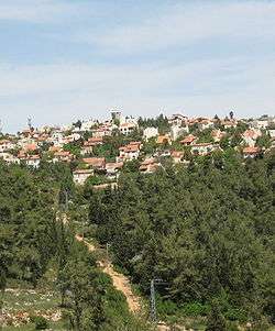
Har Adar
Har Adar
| |
|---|---|
 | |
 Har Adar | |
| Coordinates: 31°49′34″N 35°07′47″E / 31.82611°N 35.12972°ECoordinates: 31°49′34″N 35°07′47″E / 31.82611°N 35.12972°E | |
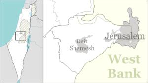
| Region | West Bank |
| District | Judea and Samaria Area |
| Founded | 1982 |
| Government | |
| • Type | Local council (from 1995) |
| • Head of Municipality | Aviram Cohen (since 2004) |
| Area | |
| • Total | 994 dunams (99.4 ha or 246 acres) |
| Population (2015)[1] | |
| • Total | 3,858 |
| Name meaning | Mount Adar |
Har Adar (Hebrew: הַר אֲדָר) is an Israeli settlement and local council in the Seam Zone and the Maccabim sub-region of the West Bank. Founded in 1982,[2] it had a population of 3,858 in 2015. It is located near Abu Ghosh and the Green Line on Road 425, approximately 15 kilometers west of Jerusalem. Har Adar is ranked high on the Israeli socio-economic scale, at 9/10.[3]
History

The location of Har Adar was named Radar Hill (Hebrew: גִּבְעַת הָרָדָאר, Giv'at HaRadar), for the World War II British military installation there which had an anti-air radar for the protection of Jerusalem. The installation was handed over to the Jordanian Arab Legion on May 10, 1948, prior to the second phase of the 1948 Arab-Israeli War.[4] 23 attempts by the Palmach's Harel Brigade to conquer it failed,[2] although the Jewish force held the position for four days starting May 22, 1948.[4] It was finally captured in the Six-Day War by the Harel Brigade. A monument for the fallen soldiers of the brigade stands at the top of the town.[2]
The current settlement was founded in 1982 by the Radar Hill Organization. Har Adar (lit. The Radar or Mount Adar ) was a similar-sounding Hebrew name given to the hill and the settlement.[2]
Demographics

In 2009, the population of Har Adar was 99.3% Jewish, with a more or less even distribution of men and women (1,700 men and 1,600 women).[3] The age distribution was as follows:
| Age | 0–4 | 5–9 | 10–14 | 15–19 | 20–29 | 30–44 | 45–59 | 60–64 | 65–74 | 75+ |
|---|---|---|---|---|---|---|---|---|---|---|
| Percentage | 9.6 | 10.3 | 9.8 | 8.0 | 12.4 | 20.3 | 17.6 | 6.7 | 4.4 | 0.9 |
| Source: Israel Central Bureau of Statistics[3] | ||||||||||
Economy
Har Adar is ranked 9/10 (high) on the Israeli socio-economic scale.[3] According to Business Data Israel (BDI), in 2006 Har Adar had the most stable economy of all Israeli local councils, along with Kfar Shmaryahu.[5] In 2009, the municipal surplus stood at NIS 187,000.[3]
In 2009, there were 1,471 salaried workers in Har Adar. The average salary for males was NIS 15,987, and 8,882 for women – both higher than the national average. 25.5% salaried workers worked for minimum wage. In addition, there were 143 self-employed workers, with an average income of NIS 12,311.[3]
References
- ↑ "List of localities, in Alphabetical order" (PDF). Israel Central Bureau of Statistics. Retrieved 16 October 2016.
- 1 2 3 4 HaReuveni, Immanuel (1999). Lexicon of the Land of Israel (in Hebrew). Miskal - Yedioth Ahronoth Books and Chemed Books. p. 255. ISBN 965-448-413-7.
- 1 2 3 4 5 6 "Local Authorities in Israel 2009, Publication #1451 - Municipality Profiles - Har Adar" (PDF) (in Hebrew). Israel Central Bureau of Statistics. Retrieved September 8, 2011.
- 1 2 Vilnai, Ze'ev (1976). "Giv'at HaRadar". Ariel Encyclopedia (in Hebrew). Volume 2. Israel: Am Oved. pp. 1165–1166.
- ↑ "Har Adar: The Most Economically Organized Council". Emtza HaShavu'a (Jerusalem) (in Hebrew). Yedioth Ahronoth. February 26, 2008.
See also
'Israeli settler and Palestinian cooperate to save horned owl,' Ynet 23 January 2015.
External links
- Har Adar local council web site (Hebrew)
| Cities | ||
|---|---|---|
| Regional committee | ||
| Regional councils | ||
| Local councils | ||
| See also | ||