Hapcheon County
| Hapcheon 합천군 | ||
|---|---|---|
| County | ||
| Korean transcription(s) | ||
| • Hangul | 합천군 | |
| • Hanja | 陜川郡 | |
| • Revised Romanization | Hapcheon-gun | |
| • McCune-Reischauer | Hapch'ŏn-gun | |
|
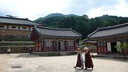
Hapcheon is known for Haeinsa temple | ||
| ||
 Location in South Korea | ||
| Country |
| |
| Region | Yeongnam | |
| Administrative divisions | 1 eup, 16 myeon | |
| Area | ||
| • Total | 983.42 km2 (379.70 sq mi) | |
| Population (2003) | ||
| • Total | 60,160 | |
| • Density | 61.2/km2 (159/sq mi) | |
| • Dialect | Gyeongsang | |
Hapcheon County (Hapcheon-gun) is a county in South Gyeongsang Province, South Korea. Famous people born in the county include former South Korean president Chun Doo-hwan.
Location
Located in northwestern Gyeongsangnam-do, the county is surrounded by Changnyeong as well as Euiryeong to the Southeast, Geochang as well as Sancheong-gun to the West. High and precipitous hills are densely situated and the eastern part is flatter by the flowing streams of the Nakdong River.[1]
Places of interest
Haeinsa is a famous temple located in Hapcheon county.
Mt. Namsan Jeilbong is known for its climbing trails, and offers spectacular views year round. Its address is Chiin-li, Gaya-myun, Hapcheon, Gyeongnam.
Special products
Paprika is a popular agriculture good cultivated on the highlands of Mt. Gaya during the summer season. It is hence called Gaya paprika. This paprika is often exported to Japan.[2]
Places
Hapcheon has its own spectacular places distinctively different from other regions. One of the best is the "Imagination" theme park which is however. not very well known. In the park, people can play a survival game under an imaginative war state.
Hapcheon lake is also a tourist spot bordering Sancheong county. It is an artificial lake generated by the comprehensive development plan of Nakdong River in 1988. It also meets Hwangmae mountain which is possible to climb and from the peak, there are impressive sceneries of the lake.[3]
Paragliding is also possible in Hapcheon, however it should be noted that there were people killed during the county paragliding championship in 2007.[4]
Climate
As Hapcheon-gun is landlocked, the climate is quite extreme. Average annual temperature is 13.0°C with the lowest temperature of -16.9°C (in 1974)[5] and the highest of 39.2°C (in 1994).[6] The rainfall is approximately 1275.6mm which is quite low compared to other Korean regions. The rainfall is heaviest in the summer.
| Climate data for Hapcheon (1981–2010) | |||||||||||||
|---|---|---|---|---|---|---|---|---|---|---|---|---|---|
| Month | Jan | Feb | Mar | Apr | May | Jun | Jul | Aug | Sep | Oct | Nov | Dec | Year |
| Average high °C (°F) | 6.7 (44.1) |
9.2 (48.6) |
14.0 (57.2) |
20.6 (69.1) |
25.0 (77) |
28.0 (82.4) |
29.9 (85.8) |
30.7 (87.3) |
26.8 (80.2) |
22.2 (72) |
15.3 (59.5) |
9.2 (48.6) |
19.8 (67.6) |
| Daily mean °C (°F) | −0.5 (31.1) |
1.9 (35.4) |
6.8 (44.2) |
13.0 (55.4) |
17.9 (64.2) |
21.9 (71.4) |
25.0 (77) |
25.4 (77.7) |
20.7 (69.3) |
14.2 (57.6) |
7.5 (45.5) |
1.6 (34.9) |
13.0 (55.4) |
| Average low °C (°F) | −6.1 (21) |
−4.2 (24.4) |
0.4 (32.7) |
5.8 (42.4) |
11.2 (52.2) |
16.6 (61.9) |
21.2 (70.2) |
21.4 (70.5) |
16.0 (60.8) |
8.3 (46.9) |
1.5 (34.7) |
−4.1 (24.6) |
7.3 (45.1) |
| Average precipitation mm (inches) | 21.9 (0.862) |
34.7 (1.366) |
53.2 (2.094) |
74.0 (2.913) |
97.4 (3.835) |
168.9 (6.65) |
287.4 (11.315) |
294.5 (11.594) |
158.0 (6.22) |
38.3 (1.508) |
32.0 (1.26) |
15.2 (0.598) |
1,275.6 (50.22) |
| Average precipitation days (≥ 0.1 mm) | 3.8 | 4.8 | 6.5 | 7.7 | 8.6 | 9.5 | 13.5 | 12.9 | 8.7 | 4.5 | 4.7 | 3.4 | 88.6 |
| Average relative humidity (%) | 63.4 | 61.5 | 60.0 | 58.9 | 63.4 | 69.3 | 76.2 | 76.3 | 75.5 | 71.7 | 68.9 | 65.7 | 67.6 |
| Mean monthly sunshine hours | 188.4 | 185.0 | 205.4 | 218.8 | 227.1 | 183.7 | 160.0 | 176.9 | 171.0 | 202.1 | 174.2 | 182.2 | 2,277.7 |
| Source: Korea Meteorological Administration[7] | |||||||||||||
Sister cities
 Bergen County, New Jersey, United States
 Mitoyo, Kagawa, Japan
  Jangsu, North Jeolla, South Korea
  Xinchang, China
See also
References
- ↑ Official page
- ↑ Official page of county
- ↑ <<Mountains>> Monthly issued magazine 황매산 & 합천호 2007-10
- ↑ 2 Paragliders fell down...1 died합천서 패러글라이더 2명 추락..1명 사망 Yeonhap news 2007.05.27 http://news.naver.com/main/read.nhn?mode=LSD&mid=sec&sid1=102&oid=001&aid=0001648305
- ↑ 기후자료극값(최대값)
- ↑ 기후자료극값(최대값)
- ↑ "평년값자료(1981–2010) 합천(285)". Korea Meteorological Administration. Retrieved 2011-05-11.
External links

Coordinates: 35°33′59″N 128°09′58″E / 35.566497°N 128.166007°E