Haparanda
| Haparanda | |
|---|---|
|
Haparanda railway station | |
 Haparanda  Haparanda | |
| Coordinates: 65°50′N 024°08′E / 65.833°N 24.133°ECoordinates: 65°50′N 024°08′E / 65.833°N 24.133°E | |
| Country | Sweden |
| Province | Norrbotten |
| County | Norrbotten County |
| Municipality | Haparanda Municipality |
| Area[1] | |
| • Total | 4.43 km2 (1.71 sq mi) |
| Population (31 December 2010)[1] | |
| • Total | 4,856 |
| • Density | 1,097/km2 (2,840/sq mi) |
| Time zone | CET (UTC+1) |
| • Summer (DST) | CEST (UTC+2) |

Haparanda (Finnish: Haaparanta, meaning aspen beach) is a locality and the seat of Haparanda Municipality in Norrbotten County, Sweden. It is adjacent to Tornio, Finland. Haparanda had a population of 4,856 in 2010,[1] of out of a municipal total of 10,200 inhabitants.
Haparanda is, despite its small population, for historical reasons often still referred to as a city. Statistics Sweden, however, only counts localities with more than 10,000 inhabitants as cities. Haparanda is located at the northerly extreme of the Swedish coastline, and far removed from large cities. Its summers are very mild for a coastal location so far north, and winters are normally not extremely cold in spite of the relative proximity to the Arctic Circle.
The municipality itself, on the other hand, uses the term Haparanda stad (City of Haparanda) not only for the town itself, but for its whole territory (927 km2 or 358 sq mi). At 24° 8' E, Haparanda is Sweden's easternmost settlement.
History

When Sweden ceded Finland to Russia in 1809, the Finnish–Swedish border was drawn along the Rivers Tornio and Muonio. The town of Tornio, located on the island Suensaari in the river delta became part of the Grand Duchy of Finland within the Russian Empire as demanded by czar Alexander I. (Finland declared independence in 1917).
At that time the town of Tornio was dominated by Swedish-speaking merchants and craftsmen, forming a linguistic island in a Finnish-speaking countryside. After the war many of the Swedes started to develop the small village Haaparanta across the border instead (Haparanda and Tornio are within walking distance), eventually leaving Tornio unilingually Finnish. Haparanda was made a market town (köping) in 1821 and received its city charter in 1842.
Into the early twentieth century Haparanda enjoyed commercial and political significance out of proportion to its size because of its position at the mouth of the Torne river at the head of the Gulf of Bothnia. Timber and furs from across northern Scandinavia and Russia arrived by water for shipping on to the rest of the world via the Baltic. Arctic and Antarctic expeditions of the 19th and 20th centuries, including that of Admiral Peary of the US, wore furs supplied by Hermansons, whose shop still stands in Haparanda, albeit closed now. Haparanda was the only open railway border crossing at the border to Russia during World War I.
Sports
Haparanda/Tornio play in the second tier bandy division in Sweden, allsvenskan. Haparanda hosted matches in the Bandy World Championship 2001.
Other sports clubs located in Haparanda include:
- Asplöven HC (ice hockey)
- Haparanda FF (soccer)
The impact of the Finland-Sweden international border

Relations between the neighbouring towns have always been friendly. A large portion of Haparanda's population speak both Swedish and Finnish. Today the two towns are closely interconnected economically and socially; they constitute a transborder conurbation marketed as "EuroCity". Since Sweden and Finland are in different time zones, Haparanda is one hour behind Tornio. This allows a unique spectacle on New Year's Eve, when people can welcome in the new year twice. Since 2005 the cities have rebranded themselves as "Haparanda-Tornio" in Sweden, and "Tornio-Haparanda" in Finland.
Haparanda has a railway station, but the line is now only used for freight. The station buildings are used by a youth club, and occasionally for concerts. They include what were originally customs and border control posts. This was the only route open between Russia and Germany in World War I, and during World War II many of the approximately 80,000 Finnish children evacuated to Sweden entered the country here.
Rail gauge
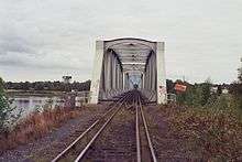
Haparanda is connected to the Swedish national network by the Haparandabanan (Haparanda railway). The bridge between Haparanda and Tornio is the only direct connection between the Swedish and Finnish rail systems. The two networks use different track gauges, requiring all freight wagons crossing the border to have their cargo reloaded or their bogies exchanged. There is a dual gauge track, in a 1,435 mm (4 ft 8 1⁄2 in) and 1,524 mm (5 ft) four rail gauntlet track formation, between Haparanda and Tornio.
Buildings

An IKEA retail store opened 15 November 2006 in a new commercial enterprise zone at the Haparanda-Tornio border, and is the northernmost IKEA store in the world.[2] Though goods are priced in Swedish kronor only, instore signage is in both Swedish and Finnish. This single store attracts a claimed two million visitors every year, and has triggered "piggy-back" development of other large-scale retail outlets and a prototypical US-style shopping mall on the site.[3] Although shops in Haparanda itself accept euros and Swedish kronor, many have closed in the face of competition from the out of town development.
Notable buildings besides the rail station (1918) include the Stadshotell (hotel and former town hall) of 1900, which has a first floor stateroom with magnificent chandeliers of Orrefors glass, and the landmark pepperpot-shaped watertower,[4] erected in 1920. It no longer provides all the town's water, only the communal hot water supply. Haparanda's uncompromisingly modern church is by Bengt Larsson of the ELLT studio, and dates from 1967, its predecessor being destroyed by fire in 1964.
Plans for a new building containing a multipurpose arena seating 2,500 and more commercial development were announced in 2013. It will be sited on the border and is due for completion by 2016.
Climate
Haparanda has a subarctic climate courtesy of its northerly position, but in spite of this classification the climate is often quite mild. The marine airflow from the mild North Atlantic tempers winters in spite of the low sun, whilst Haparanda retains enough continental influence for summers to be relatively warm, especially for a coastal city so far north. This is due to the large landmass surrounding the city in most directions as well as the brief midnight sun that normally lasts around 10 days.[5] During summer, daylight is prevalent enough to allow daytime activities around the clock for a longer period than that. During the winter solstice however, Haparanda only experiences 2 hours and 56 minutes of daylight.[6]
Daytime temperature average ranges normally goes between 20 °C (68 °F) in summer to −6 °C (21 °F) in winter, with winters being milder than many continental climates. Due to summer temperatures rapidly dropping once daylight diminishes, Haparanda does not reach such a classification.
| Climate data for Haparanda, 2002-2015; precipitation 1971-2000; extremes since 1901 | |||||||||||||
|---|---|---|---|---|---|---|---|---|---|---|---|---|---|
| Month | Jan | Feb | Mar | Apr | May | Jun | Jul | Aug | Sep | Oct | Nov | Dec | Year |
| Record high °C (°F) | 8.4 (47.1) |
7.8 (46) |
10.3 (50.5) |
18.5 (65.3) |
28.8 (83.8) |
31.4 (88.5) |
32.5 (90.5) |
29.7 (85.5) |
24.0 (75.2) |
17.0 (62.6) |
11.5 (52.7) |
7.0 (44.6) |
32.5 (90.5) |
| Average high °C (°F) | −5.9 (21.4) |
−5.5 (22.1) |
−0.5 (31.1) |
5.3 (41.5) |
12.3 (54.1) |
17.6 (63.7) |
20.8 (69.4) |
18.9 (66) |
13.2 (55.8) |
5.5 (41.9) |
0.2 (32.4) |
−2.7 (27.1) |
6.6 (43.9) |
| Daily mean °C (°F) | −9.2 (15.4) |
−10.3 (13.5) |
−5.1 (22.8) |
1.1 (34) |
7.5 (45.5) |
13.0 (55.4) |
16.4 (61.5) |
14.6 (58.3) |
9.3 (48.7) |
2.5 (36.5) |
−2.7 (27.1) |
−6.0 (21.2) |
2.5 (36.5) |
| Average low °C (°F) | −13.3 (8.1) |
−13.5 (7.7) |
−9.7 (14.5) |
−3.0 (26.6) |
2.7 (36.9) |
8.2 (46.8) |
12.0 (53.6) |
10.2 (50.4) |
5.4 (41.7) |
−0.5 (31.1) |
−5.2 (22.6) |
−9.4 (15.1) |
−0.8 (30.6) |
| Record low °C (°F) | −40.8 (−41.4) |
−41.7 (−43.1) |
−37.5 (−35.5) |
−26.0 (−14.8) |
−10.5 (13.1) |
−1.5 (29.3) |
2.2 (36) |
−1.8 (28.8) |
−8.1 (17.4) |
−23.0 (−9.4) |
−32.3 (−26.1) |
−37.3 (−35.1) |
−41.7 (−43.1) |
| Average precipitation mm (inches) | 47.2 (1.858) |
36.7 (1.445) |
38.2 (1.504) |
31.0 (1.22) |
34.6 (1.362) |
43.2 (1.701) |
56.8 (2.236) |
67.0 (2.638) |
62.6 (2.465) |
63.7 (2.508) |
61.6 (2.425) |
47.5 (1.87) |
590.1 (23.232) |
| Source #1: [7] | |||||||||||||
| Source #2: [8] | |||||||||||||
See also
References
- 1 2 3 "Tätorternas landareal, folkmängd och invånare per km2 2005 och 2010" (in Swedish). Statistics Sweden. 14 December 2011. Archived from the original on 10 January 2012. Retrieved 10 January 2012.
- ↑ http://www.ft.com/cms/s/0/10abe038-cd6f-11dd-9905-000077b07658.html
- ↑ http://turism.haparanda.se/english/homepage.4.724fa9011b116c75428000324830.html
- ↑ Watertower
- ↑ "Haparanda, Sweden; sunrise and sunset for June 2016". Sunrise and Sunset.com. Retrieved 8 January 2016.
- ↑ "Haparandra, Sweden; sunrise and sunset for December 2016". Sunrise and Sunset.com. Retrieved 8 January 2016.
- ↑ "SMHI".
- ↑ "SMHI Average Monthly Data 2002-2015".
External links
Municipalities and seats of Norrbotten County | ||
|---|---|---|
| Municipalities | ||
| Municipal seats | ||