Hangman cliffs
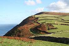
Hangman cliffs, consisting of Great Hangman and Little Hangman are near Combe Martin on the north coast of Devon, England, where Exmoor meets the sea.
Great Hangman, with its summit at grid reference SS601481, is 1,043 feet (318 m) high with a cliff face of 800 feet (244 m). It is the highest sea cliff in England[1] and the highest point on the South West Coast Path.[2] Little Hangman is 716 feet (218 m) high and overlooks the village of Combe Martin at the western boundary of Exmoor National Park. Both cliffs lie on the South West Coast Path and are in an Area of Outstanding Natural Beauty. The cliffs are formed from a considerable thickness of sandstone known as the Hangman Grits (or more formally the Hangman Sandstone Formation) laid down during the Devonian Period. They were subsequently folded during the Variscan Orogeny and the strata is seen locally to dip southwards at between 25 and 35 degrees. There is an abandoned working for iron ore below Great Hangman at Blackstone Point.[3]
No early forms of the place-name Hangman here are recorded: its first mention, as Hangman Hill, was in 1792.[4] However, there is a fanciful derivation of the name, based on a local legend. The story goes that a sheep stealer was walking over the hill carrying a stolen ewe slung over his shoulder. He stopped to rest on a rock and the struggling sheep caused the cord tied around its legs to tighten and slip round the man's neck, strangling him.[5] In all liklihood the name 'Hangman' is a mixture of Celtic and Germanic languages. 'Mynedd' in Celt means hill and 'hang' is the Germanic word for slope. There are other examples of hills being called 'man' from Celtic origin e.g. Old Man of Hoy or East/West Man in Purbeck. The literal translation for Hangman would be sloping hill.[6]
In fiction, Great Hangman is part of the setting of Meet the Tiger, the first in a long series of novels by Leslie Charteris featuring "The Saint". Simon Templar stays on Great Hangman in an abandoned World War I pillbox so he can find out about a Chicago gangster staying in Baycombe aka Combe Martin.
References
- ↑ "Combe Martin and the Hangmans". Exmoor National Park. Retrieved 2012-10-11.
- ↑ "South West Coast Path". National Trails. Retrieved 2007-12-05.
- ↑ British Geological Survey 1981 Ilfracombe England and Wales sheet 277 Solid & Drift Geology. 1:50,000 scale geological map (Keyworth, Nottingham: British Geological Survey)
- ↑ Gover, J.E.B., Mawer, A. & Stenton, F.M (1931). "The Place-Names of Devon". English Place-Name Society. Vol viii. Part I. Cambridge University Press: 37.
- ↑ See for instance: Page, John Lloyd Warden (1895). The Coasts of Devon and Lundy Island. London: Horace Cox. p. 53.
- ↑ Roland Tarr, 1994, South West Coast Path: Minehead to Padstow,p.53
Coordinates: 51°13′00″N 4°00′52″W / 51.21654°N 4.01451°W