Hanamigawa-ku
| Hanamigawa 花見川区 | |
|---|---|
| Ward | |
| Hanamigawa Ward | |
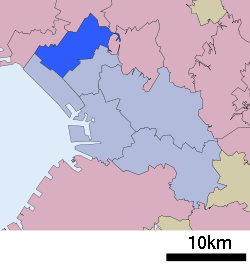 Location of Hanamigawa Ward in Chiba | |
 Hanamigawa
| |
| Coordinates: 35°39′46″N 140°04′09″E / 35.66278°N 140.06917°ECoordinates: 35°39′46″N 140°04′09″E / 35.66278°N 140.06917°E | |
| Country | Japan |
| Region | Kantō |
| Prefecture | Chiba |
| City | Chiba |
| Area | |
| • Total | 34.24 km2 (13.22 sq mi) |
| Population (April 2012) | |
| • Total | 179,770 |
| • Density | 5,300/km2 (14,000/sq mi) |
| Time zone | Japan Standard Time (UTC+9) |
| Address |
1-1 Mizuho, Hanamigawa-ku Chiba-shi, Chiba-ken 262-8733 |
| Website | Official website of Hanamigawa-ku |
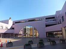
Hanamigawa Ward Office (Dec 20, 2011)
Hanamigawa Ward (花見川区 Hanamigawa-ku) is one of the six wards of the city of Chiba in Chiba Prefecture, Japan. As of April 2012, the ward has an estimated population of 179,770 and a population density of 5,250 persons per km². The total area is 34.24 km².[1]
Geography
Hanamigawa Ward is located inland in the northernmost part of the city of Chiba. The ward takes its name from the Hanami River, which flows through the ward.
Transportation
Railroads
Education
The Chiba Korean Primary and Junior High School, a North Korea-aligned Korean international school, is located in Hamamigawa-ku.[2]
References
- ↑ 千葉市の推計人口. Chiba official website (in Japanese). Chiba city. Retrieved 6 September 2011.
- ↑ Home page. Chiba Korean Primary and Junior High School. Retrieved on April 12, 2015. "千葉県千葉市花見川区浪花町965"
| Wikimedia Commons has media related to Hanamigawa-ku, Chiba. |
| Wards of Chiba | ||
|---|---|---|
| Core cities | ||
| Cities | ||
| Inba District | ||
| Katori District | ||
| Sanbu District | ||
| Chōsei District | ||
| Isumi District | ||
| Awa District | ||
This article is issued from Wikipedia - version of the 9/18/2016. The text is available under the Creative Commons Attribution/Share Alike but additional terms may apply for the media files.