Hamelin-Pyrmont
| Hamelin-Pyrmont | ||
|---|---|---|
| District | ||
| ||
 | ||
| Country |
| |
| State | Lower Saxony | |
| Capital | Hamelin | |
| Area | ||
| • Total | 796 km2 (307 sq mi) | |
| Population (31 December 2015)[1] | ||
| • Total | 148,281 | |
| • Density | 190/km2 (480/sq mi) | |
| Time zone | CET (UTC+1) | |
| • Summer (DST) | CEST (UTC+2) | |
| Vehicle registration | HM | |
| Website | hameln-pyrmont.de | |
Hamelin-Pyrmont (German: Landkreis Hameln-Pyrmont) is a district (Landkreis) in Lower Saxony, Germany. It is bounded by (from the north and clockwise) the districts of Schaumburg, Hanover, Hildesheim and Holzminden, and by the state of North Rhine-Westphalia (district of Lippe).
History
A district called Hamelin was established in 1885 within the Prussian Province of Hanover. At that time the city of Pyrmont was part of the Principality of Waldeck-Pyrmont. In 1921 Pyrmont decided in a plebiscite to leave Waldeck-Pyrmont and to join Prussia. The Prussian administration assigned the city to the district of Hamelin, which was renamed to Hamelin-Pyrmont.
In 1923 Hamelin became a district-free city and was not part of the district until 1973, when it was reincorporated. Further enlargements of the district's territory took place in 1974 and 1977, when the cities of Bad Münder and Hessisch Oldendorf joined the district.
Geography
The district is located in the northern part of the Weserbergland mountains. The Weser River enters the district in the south, runs through Hamelin and leaves in the northwest towards Rinteln.
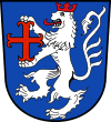
Coat of arms
The lion is the heraldic animal of the County of Everstein, which ruled over the territory until 1429. The red cross in the lion's hands was the symbol of Pyrmont.
Towns and municipalities
| Cities | Municipalities |
|---|---|
|
See also
References
External links
![]() Media related to Landkreis Hameln-Pyrmont at Wikimedia Commons
Media related to Landkreis Hameln-Pyrmont at Wikimedia Commons
- Official website of Hamelin-Pyrmont (German)
- Official website of Salzhemmendorf (German)
- bed and rich breakfast at Salzhemmendorf, district Lauenstein (English)
| Region | |
|---|---|
| Urban districts | |
| Rural districts |
|
Coordinates: 52°05′N 9°20′E / 52.08°N 9.33°E