Hambury Tout
| Hambury Tout | |
|---|---|
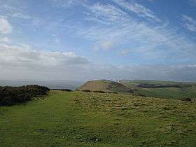 Hambury Tout seen from Bindon Hill on the eastern side of Lulworth Cove | |
| Highest point | |
| Elevation | 134 m (440 ft) [1] |
| Geography | |
| Location | Dorset, England |
| Parent range | Purbeck Hills |
| OS grid | SY815802 |
| Topo map | OS Landranger 194 |
Hambury Tout is a large chalk hill by the coast near Lulworth, Dorset, England.[2] It overlooks Lulworth Cove to the west. Hambury Tout is the site of an ancient burial mound.[3]
References
- ↑ Ordnance Survey Landranger 1:50,000 map series, No. 194.
- ↑ http://www.knowledgerush.com/kr/encyclopedia/Lulworth_Cove/
- ↑ http://www.accesslanguages.co.uk/pb2k/durdle.html
Coordinates: 50°37′19″N 2°15′42″W / 50.6220°N 2.2617°W
This article is issued from Wikipedia - version of the 5/27/2016. The text is available under the Creative Commons Attribution/Share Alike but additional terms may apply for the media files.