Hamburg-Mitte
| Hamburg-Mitte | |||
|---|---|---|---|
| First-level subdivision of Hamburg | |||
| |||
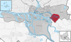
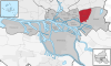
 Location of Hamburg-Mitte within Hamburg | |||
| Coordinates: 53°33′1″N 9°59′39″E / 53.55028°N 9.99417°ECoordinates: 53°33′1″N 9°59′39″E / 53.55028°N 9.99417°E | |||
| Country | Germany | ||
| State | Hamburg | ||
| City | Hamburg | ||
| Area | |||
| • Total | 142.2 km2 (54.9 sq mi) | ||
| Elevation | 10 m (30 ft) | ||
| Population (31 December 2013) | |||
| • Total | 289,876 | ||
| • Density | 2,000/km2 (5,300/sq mi) | ||
| Time zone | CET (UTC+1) | ||
| Dialling code(s) | 040 | ||
| ISO 3166 code | DE-HH | ||
| Vehicle registration | HH | ||
| Website |
www | ||
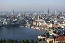
Hamburg-Mitte (approximate translation: Hamburg center) is one of the seven boroughs of the Free and Hanseatic City of Hamburg, Germany, covering most of the city's urban center. The quarters Hamburg-Altstadt and Neustadt are the historic origin of Hamburg. In 2006 the population was 233,144.
History
In 1937 several settlements (e.g. Finkenwerder), villages and rural areas were passed into Hamburg enforced by the Greater Hamburg Act.
On March 1, 2008 due to a law of Hamburg,[1] the quarter Wilhelmsburg was transferred from the borough Harburg. The neighborhood HafenCity was formed from parts of the quarters Klostertor, Altstadt and Rothenburgsort. The other part of Klostertor was transferred to Hammerbrook. From small parts of the borough Hamburg-Mitte (And Altona and Eimsbüttel) the neighborhood Sternschanze was created as a quarter in the borough Altona.
Geography

The borough severs Hamburg from the east to the west. In 2006, according to the statistical office of Hamburg and Schleswig-Holstein, Hamburg-Mitte has a total area of 107.1 square kilometres (41 sq mi).
Subdivisions
Hamburg-Mitte consists of the quarters Billbrook, Billstedt, Borgfelde, Finkenwerder, HafenCity, Hamburg-Altstadt, Hamburg-Hamm, Hammerbrook, Horn, Kleiner Grasbrook, Neustadt, Neuwerk, Rothenburgsort, St. Georg, St. Pauli, Steinwerder, Veddel, Waltershof and Wilhelmsburg.
|
|
|
|


The historic center of Hamburg lies within the districts Altstadt, Neustadt and HafenCity, also defined by being inside the Wallring. These three districts also constitute what is considered Hamburg's Innenstadt (inner city).
Green and open spaces
Planten un Blomen (plants and flowers) is a park located in the quarter St. Pauli and Neustadt. Located in the quarter Billstedt is the lake Öjendorfer See.
Culture
Museums and cultural institutions
Economy
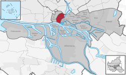
.jpg)
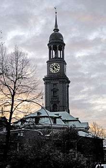
Hamburg-Mitte is the economic center of Hamburg. Altstadt, Neustadt and HafenCity make up Hamburg's Innenstadt (inner city), the city's shopping and central business district, while Hammerbrook's City Süd is an important decentralized business district. The facilities of the Port of Hamburg are located mostly in Hamburg-Mitte in the quarters of Kleiner Grasbrook, Steinwerder, Veddel, Waltershof and Wilhelmsburg.
Politics
The Bezirksamt Hamburg-Mitte is located at Klosterwall 8.
Diet of the borough
Simultaneously with elections to the state parliament (Bürgerschaft), the Bezirksversammlung is elected as representatives of the citizens. It consists of 53 representatives.
Elections
Elections were held in Hamburg on 24 February 2008. The four parties having more than 5 percent in recent polls (minimum to qualify) are the social-democratic SPD, the conservative CDU, the ecologist Green Party (GAL) and the left-wing Die Linke. The liberal Free Democratic Party (FDP) has 2 directly elected representatives.[2]

| Party | Percent | Seats |
|---|---|---|
| SPD | 37.2 | 21 |
| CDU | 31.6 | 17 |
| GAL | 13.2 | 7 |
| Die Linke | 10.2 | 6 |
| FDP | 4.2 | 2 |
Demographics
In 2006 233,144 people lived in the borough. The population density was 2,177/km2 (5,638/sq mi). 14.9% were children under the age of 18, and 15.6% were 65 years of age or older. 43% belong to ethnic minorities.[3] 17,550 people were registered as unemployed and 72,608 were employees subject to social insurance contributions.[4]
In 1999 there were 126,753 households, out of which 17.9% had children under the age of 18 living with them and 52.4% of all households were made up of single occupants. The average household size was 1.83.[5]
Population by year[4]
| 1987 | 1988 | 1989 | 1990 | 1991 | 1992 | 1993 | 1994 | 1995 | 1996 | 1997 | 1998 | 1999 |
| 232,467 | 235,759 | 242,434 | 249,156 | 250,585 | 252,695 | 251,965 | 248,802 | 246,374 | 242,029 | 237,648 | 230,542 | 228,349 |
| 2000 | 2001 | 2002 | 2003 | 2004 | 2005 | 2006 | 2007 | 2008 | 2009 |
| 228,060 | 227,199 | 227,915 | 228,117 | 227,557 | 230,680 | 233,114 |
In 2006 there were 71,559 criminal offences in borough (307 crimes per 1000 people).[6]
Infrastructure
The main local office (Bezirksamt Hamburg-Mitte) is located on Klosterwall. It has 4 local offices or "Customer Centres." These are Customer Centre Hamburg-Mitte, Customer Centre Billstedt, Customer Centre St. Pauli, and Customer Centre Wilhelmsburg. The offices are responsible, among other things, for the application for a residence permit for purposes of study after entering the country.
Government
The Federal Maritime and Hydrographic Agency of Germany (BSH) has its head office in St. Pauli in Hamburg-Mitte,[7] and the head office of Federal Bureau for Maritime Casualty Investigation is in the BSH facility.[8]
Education
The borough has 31 elementary schools and 31 secondary schools.[9]
Health systems
There were 125 day-care centers for children and 536 physicians in private practice and 72 pharmacies.[9] The Asklepios Klinik St. Georg located in the quarter St. Georg, is the main hospital in Hamburg-Mitte.
Sports
Transport
The borough is serviced by the rapid transit system of the city train and the underground railway with several stations. The central station Hamburg Hauptbahnhof is also for long-distance passenger trains for the German railway company.
According to the Department of Motor Vehicles (Kraftfahrt-Bundesamt), in the Hamburg-Mitte borough 66,831 private cars were registered (290 cars/1000 people).[9] There were 2,432 traffic accidents in total, including 1,905 traffic accidents resulting in injuries.[10]
Notes
- ↑ Act of the areal organisation
- ↑ Final election result, source: statistical office of Hamburg and Schleswig-Holstein (2008)
- ↑ http://www.statistik-nord.de/uploads/tx_standocuments/SI_SPEZIAL_V_2010_01.pdf
- 1 2 Residents registration office, source: statistical office Nord of Hamburg and Schleswig-Holstein (31.12.2006)
- ↑ Source: statistical office Nord of Hamburg and Schleswig-Holstein (1999)
- ↑ State Investigation Bureaux (Landeskriminalamt), source: statistical office Nord of Hamburg and Schleswig-Holstein (2006)
- ↑ "Impressum." Federal Maritime and Hydrographic Agency of Germany. Retrieved on April 19, 2014. "Bundesamt für Seeschifffahrt und Hydrographie (BSH) Bernhard-Nocht-Straße 78 20359 Hamburg Postfach 30 12 20 20305 Hamburg"
- ↑ "Imprint." Federal Bureau for Maritime Casualty Investigation. Retrieved on 16 January 2012. "Bundesstelle für Seeunfalluntersuchung (BSU) Bernhard-Nocht-Strasse 78 20359 Hamburg " - Map
- 1 2 3 Source: statistical office Nord of Hamburg and Schleswig-Holstein (31.12.2006)
- ↑ Traffic accident statistic, statistical office Nord of Hamburg and Schleswig-Holstein (2006)
References
- Statistical office Hamburg and Schleswig-Holstein Statistisches Amt für Hamburg und Schleswig-Holstein, official website (German)
- Act of the areal organisation, July 6, 2006 Gesetz über die räumliche Gliederung der Freien und Hansestadt Hamburg (RäumGiG) (German)
External links
| Wikimedia Commons has media related to Hamburg-Mitte. |
Freie und Hansestadt Hamburg | |
| Government and Symbols | |
| History and Culture | |
| Economy and Transport | |