Halifax Peninsula
| Halifax Peninsula | |
|---|---|
| Community | |
 Location of Halifax Peninsula | |
| Country |
|
| Province |
|
| Municipality | Halifax Regional Municipality |
| Community | Halifax |
| Founded | 1749 |
| Neighborhoods | Armdale, Downtown, Hydrostone, North End, Quinpool, South End, Spring Garden, West End |
| Government | |
| • Council | Peninsula Council |
| Population (2006)[1] | |
| • Total | 58,025 |
| Time zone | AST (UTC−4) |
| • Summer (DST) | ADT (UTC−3) |
| Postal code span | B3K, B3H, B3J |
| Area code(s) | 902 |
|
Part of a series about Places in Nova Scotia | |
The Halifax Peninsula is a community and planning area located in the urban core of Halifax Regional Municipality (HRM) in the province of Nova Scotia. Halifax Peninsula is home to Downtown Halifax, the financial and economic heart of the region, which was also the site of the original settlement and town of Halifax. It is also home to the majority of the area of Nova Scotia's Capital District.
The town of Halifax was founded by the British government under the direction of the Board of Trade and Plantations under the command of Governor Edward Cornwallis in 1749.[2]
After a protracted struggle between residents and the Executive Council of Nova Scotia, the City of Halifax was incorporated in 1841. In 1969, the city, which then covered the entire peninsula, annexed the Mainland Halifax area as well. On 1 April 1996, the government of Nova Scotia formed Halifax Regional Municipality, a single-tier regional government governing all of Halifax County. The City of Halifax became a provincial metropolitan area, and the HRM divided the former city into two separate community planning areas, Halifax Peninsula and Mainland Halifax, with separate community councils inside of the regional government.
Geographically, the Halifax Peninsula is a Canadian peninsula in central Nova Scotia.
History
Although now located entirely within HRM, the peninsula was the original host to the town and now former City of Halifax.
The town of Halifax was founded by the British government under the direction of the Board of Trade and Plantations under the command of Governor Edward Cornwallis in 1749. The founding of the town sparked Father Le Loutre's War. The original settlement was clustered in the southeastern part of the peninsula along The Narrows, between a series of forts (Fort Needham to the north, Fort George (Citadel Hill) in the middle, and Fort Massey to the south) and the harbour. The settlement expanded beyond its walls and gradually encroached over the entire peninsula, creating residential neighbourhoods defined by the peninsula's geography (in addition to the central business district) and referred to by Haligonians as:
- North End
- South End, including Point Pleasant Park at the southernmost part of the peninsula
- West End
The streets are set in a grid pattern the way town officials originally planned in the 18th century.
After a protracted struggle between residents and the Executive Council, the city was incorporated to in 1841. The former city of Halifax was contained entirely within the Halifax Peninsula; however in 1969, municipal amalgamation saw adjacent rural areas of Halifax County west of the isthmus amalgamated into the city, including Rockingham and Spryfield.
During this time, Rudyard Kipling paid homage to Halifax in his poem The Song of Cities:
- Into the mist my guardian prows put forth,
- Behind the mist my virgin ramparts lie,
- The Warden of the Honour of the North,
- Sleepless and veiled am I!
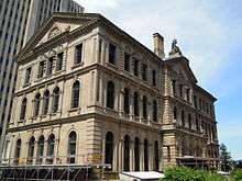
At this time the Halifax Public Gardens and Victoria Park, Halifax were created, with many Victorian Era monuments. Builders such as George Lang created many landmark buildings.
During 1916–1919 a mega construction project was undertaken by Canadian Government Railways (later Canadian National Railway) along the peninsula's Northwest Arm shoreline which saw a 4 km long rock cut blasted up to 30 m deep for a railway line running from Fairview Cove to serve the new Halifax Ocean Terminals which were built at the southeastern end; the rock from blasting work in the cut being used as infill for a portion of The Narrows.
Following the dissolution of the city of Halifax in 1996 with the creation of the HRM, the peninsula has been referred to as the Halifax Peninsula by the municipal government, with the areas of Rockingham and Spryfield being included in the Halifax Mainland district.
Geography

Extending from the western shore of Halifax Harbour, the peninsula is connected to the much larger Chebucto Peninsula by an isthmus measuring 2.6 km, defined by Fairview Cove and the Bedford Basin to the north and the Northwest Arm to the southwest. Down the length of this isthmus is Joseph Howe Drive, generally considered to be the boundary between the Halifax Peninsula and Mainland Halifax. The Halifax Peninsula creates The Narrows, a constriction of Halifax Harbour to its east.
Measuring 3.3 km at its widest and 7.5 km at its longest, the peninsula's topography is relatively flat near the isthmus where Chebucto Field, an aerodrome that preceded Halifax Stanfield International Airport was located. The northern end of the peninsula rises to a glacial drumlin at Fort Needham (approx. 60 m above sea level), with the central area of the peninsula being a plateau roughly 40–50 m. in elevation. Another drumlin approx. 60 m above sea level is located at Citadel Hill and immediately offshore to the east at Georges Island.
The bedrock of this peninsula is Precambrian slate. Glaciers during the Pleistocene era converted the rock surface to an olive-colored loamy till. Glaciation also removed reddish till from sedimentary rock to the north and redeposited it as a drumlin to form Citadel Hill. The stony loam to sandy loam soils are mapped as Bridgewater series on olive till and Wolfville series on the Citadel Hill drumlin.[3]
Present-day neighbourhoods

Colloquial neighbourhood names
- Downtown Halifax
- North End Halifax
- West End, Halifax
- Quinpool district
- South End Halifax
- Spring Garden
Other neighbourhood names
(subdivisions and housing development names)
Historic neighbourhood names
References
Coordinates: 44°39′26.8″N 63°35′39.9″W / 44.657444°N 63.594417°W