Haga, Tochigi
| Haga 芳賀町 | |||
|---|---|---|---|
| Town | |||
|
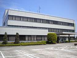
Haga Town Office | |||
| |||
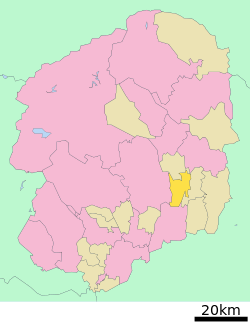 Location of Haga in Tochigi Prefecture | |||
 Haga
| |||
| Coordinates: 36°32′53.7″N 140°03′29.6″E / 36.548250°N 140.058222°ECoordinates: 36°32′53.7″N 140°03′29.6″E / 36.548250°N 140.058222°E | |||
| Country | Japan | ||
| Region | Kantō | ||
| Prefecture | Tochigi Prefecture | ||
| District | Haga | ||
| Area | |||
| • Total | 70.16 km2 (27.09 sq mi) | ||
| Population (May 2015) | |||
| • Total | 15,254 | ||
| • Density | 217/km2 (560/sq mi) | ||
| Time zone | Japan Standard Time (UTC+9) | ||
| - Tree | Zelkova serrata | ||
| - Flower | Chinese pear [1] | ||
| - Bird | Eurasian skylark [2] | ||
| Phone number | 028-677-1111 | ||
| Address | Ōaza Ubagai 1020, Haga-machi, Haga-gun, Tochigi-ken 321-3392 | ||
| Website | Official website | ||
| 321-3392 | |||


Haga (芳賀町 Haga-machi) is a town located in Haga District, Tochigi Prefecture, in the northern Kantō region of Japan. As of May 2015, the town had an estimated population of 15,254 and a population density of 217 persons per km². Its total area was 70.16 km².
Geography
Haga is located in southeastern Tochigi Prefecture. The river Gogyō, a tributary of the river Kokaigawa flows through Haga.[3]
Surrounding municipalities
History
Ubagai, Minatakazeawa and Mizuhashi villages were created within Haga District on 1 April 1889 with the creation of the municipalities system. Ubagai was elevated to town status on 1 November 1928. Ubagai merged with Minatakanezawa and Mizuhashi to form Haga on 31 March 1954.
Administration
- Town Mayor: 豊田征夫 Yukuyo Toyoda (Seventh Mayor of Haga, Mayor since 18 May 2007)
- Town Deputy Mayor: 坪川幹雄 Mikio Tsubokawa (Twelfth Deputy Mayor of Haga, Deputy Mayor since 1 October 2011)
- Superintendent of Education: 見目政子 Masako Kenmoku (Seventh Superintendent of Education, Superintendent of Education since 11 November 2012) [4]
Demographics
As of June 2013, the population of Haga is 16,319, of whom 8,132 are male and 8,187 are female.[5] The following table displays the historical populations of Haga:
| Historical populations of Haga | ||||||||||||||||||||||||||||||||||||||||||||||||||||
|---|---|---|---|---|---|---|---|---|---|---|---|---|---|---|---|---|---|---|---|---|---|---|---|---|---|---|---|---|---|---|---|---|---|---|---|---|---|---|---|---|---|---|---|---|---|---|---|---|---|---|---|---|
|
| |||||||||||||||||||||||||||||||||||||||||||||||||||
| Source: http://www.town.haga.tochigi.jp/chouseijouhou/toukeijouhou/bunya/03/documents/033_12_jinkou_kokusei_kekka.pdf, retrieved 31 July 2013 | ||||||||||||||||||||||||||||||||||||||||||||||||||||
Economy
Major companies located at Haga-machi industrial complex include:[6]
- Honda R&D Co., Ltd.
- Honda Engineering Co., Ltd.
- Kawasaki Microelectronics, Inc.
- Showa Corporation
- Marujun Co., Ltd.
- F-Tech Inc.
- Yanagawa Seiki Co., Ltd.
- AutoTechnicJapan Co., Ltd.
- Kandenko Co., Ltd.
- Kotobukido
- Sannotec
Education
Haga has three primary schools and one middle school.
Transportation
Railway
- Haga is not served by any train stations
Highway
- Japan National Route 123
- Tochigi Prefectural Roads: 61, 64, 69, 154, 156, 165, 255, 388.
- Roadside stations: Roadside Station Haga.[7]
Buses
JR Bus Kantō: Sakushin Gakuin-mae – Twin Ring Motegi via Utsunomiya Station and Motegi Station, Sakushin Gakuin mae – Saga-Onsen Roman no Yu via Utsunomiya Station.[8]
Heliports
Tochigi Heliport[9]
Notable people from Haga
References
- ↑ "芳賀町の花・木・鳥 The Flower, Tree and Bird of Hagamachi Summary". http://ww3.town.haga.tochigi.jp//. Retrieved 2013-07-31. External link in
|publisher=(help) - ↑ "芳賀町の花・木・鳥 The Flower, Tree and Bird of Hagamachi Summary". http://ww3.town.haga.tochigi.jp//. Retrieved 2013-07-31. External link in
|publisher=(help) - ↑ "鬼怒川・小貝川の概要 River Kinu and River Kokaigawa Summary". http://www.ktr.mlit.go.jp/. Retrieved 2013-07-31. External link in
|publisher=(help) - ↑ "歴代町長・副町長・収入役・教育長 Historical Mayors, Deputy Mayors, Treasurers and Superintendents of Education" (PDF). http://www.town.haga.tochigi.jp/. Retrieved 2013-07-31. External link in
|publisher=(help) - ↑ "人のうごき The Movement of People Summary". http://www.town.haga.tochigi.jp/. June 2013. Retrieved 2013-07-31. External link in
|publisher=(help) - ↑ "立地企業一覧y". http://www.hokoren.com/. Retrieved 2013-07-31. External link in
|publisher=(help) - ↑ "道の駅はが Roadside station Haga". http://www.michinoeki-haga.gr.jp/. Retrieved 2013-07-31. External link in
|publisher=(help) - ↑ "一般バス路線図 General Bus Route Maps". http://www.jrbuskanto.co.jp/. Retrieved 2013-07-31. External link in
|publisher=(help) - ↑ "栃木ヘリポートの概要 Tochigi Heliport Summary". http://www.pref.tochigi.lg.jp/. Retrieved 2013-07-31. External link in
|publisher=(help)
External links
![]() Media related to Haga, Tochigi at Wikimedia Commons
Media related to Haga, Tochigi at Wikimedia Commons
- Official website (Japanese)