Hachijō-jima
| Native name: <span class="nickname" ">八丈島 Nickname: Hachijō Island | |
|---|---|
 Hachijō-fuji | |
 | |
| Geography | |
| Location | Izu Islands |
| Coordinates | 33°06′34″N 139°47′29″E / 33.10944°N 139.79139°E |
| Archipelago | Izu Islands |
| Area | 62.52 km2 (24.14 sq mi) |
| Length | 14 km (8.7 mi) |
| Width | 7.5 km (4.66 mi) |
| Coastline | 58.91 km (36.605 mi) |
| Highest elevation | 854.3 m (2,802.8 ft) |
| Administration | |
|
Japan | |
| Demographics | |
| Population | 8363 (September 2009) |
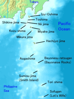
Hachijō-jima (八丈島) is a volcanic Japanese island in the Philippine Sea.[1] The island is administered by Tōkyō and located approximately 287 kilometres (178 mi) south of the Special Wards of Tōkyō. It is the southernmost and most isolated of the Izu Seven Islands group of the seven northern islands of the Izu archipelago. The chief community on the island is Mitsune; other communities are Nakanogo, Kashitate, and Ōkago all of which are administratively part of the town of Hachijō under Hachijō Subprefecture of Tokyo Metropolis. As of 2009, the island's population was 8,363 people living on 63 km2. The highest elevation is about 850 metres (2,790 feet). Hachijō-jima is also within the boundaries of the Fuji-Hakone-Izu National Park.
Geology
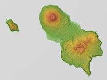
Hachijō-jima is a compound volcanic island 14.5 kilometres (9.0 miles) in length with a maximum width of 8 kilometres (5.0 miles). The island is formed from two stratovolcanoes. Higashi-yama (東山), also called Mihara-yama (三原山), has a height of 701 metres (2,300 ft), and was active from 100,000 BC to around 1700 BC, has eroded flanks and retains a distinctive caldera. Nishi-yama (西山), also called Hachijō-fuji (八丈富士)) is the highest point on the island and is the tallest peak of the entire Izu island chain, with a height of 854 metres (2,802 ft). The summit is occupied by a shallow caldera with a diameter of 400 metres (1,300 feet) and a depth of around 50 metres (160 feet). It is rated as a Class-C active volcano by the Japan Meteorological Agency with eruptions recorded in recent history in 1487, 1518, 1522–1523, 1605 and 1606. In between these two peaks are over 20 flank volcanoes and pyroclastic cones.
History
Hachijō-jima has been inhabited since at least the Jōmon period, and archaeologists have found magatama and other remains. Under the Ritsuryō system of the early Nara period, the island was part of Suruga Province. It was transferred to Izu Province when Izu separated from Suruga in 680. During the Heian period, Minamoto no Tametomo was banished to Izu Ōshima after a failed rebellion, but per a semi-legendary story, escaped to Hachijō-jima, where he attempted to establish an independent kingdom. Muromachi period documents indicate that the Kantō kubō appointed a daikan (代官) to govern Hachijō-jima on his behalf.
During the Edo period, the island became known as a place of exile for convicts, most notably Ukita Hideie, a daimyo who was defeated at the Battle of Sekigahara, but also for common criminals, especially repeat offenders and murderers. Its use as a prison island ended with the Meiji Restoration. During the Pacific War, the island was regarded as a strategic point in the defense of the ocean approaches to Tokyo, and in the final stages of the war, a base of operations for the Kaiten suicide submarines was founded on the southern coast. Following the end of World War II through the 1960s, the government made attempts to promote Hachijōjima as the "Hawaii of Japan" to encourage tourist development, and tourism remains a large component of the island's economy to date.
Climate
Hachijō-jima has a humid subtropical climate (Köppen climate classification Cfa) with very warm summers and mild winters. Precipitation is abundant throughout the year, but is somewhat lower in winter.
| Climate data for Hachijō-jima | |||||||||||||
|---|---|---|---|---|---|---|---|---|---|---|---|---|---|
| Month | Jan | Feb | Mar | Apr | May | Jun | Jul | Aug | Sep | Oct | Nov | Dec | Year |
| Average high °C (°F) | 12.9 (55.2) |
13.1 (55.6) |
15.3 (59.5) |
19.2 (66.6) |
22.0 (71.6) |
24.4 (75.9) |
27.6 (81.7) |
29.2 (84.6) |
27.5 (81.5) |
23.5 (74.3) |
19.9 (67.8) |
15.6 (60.1) |
20.85 (69.53) |
| Daily mean °C (°F) | 10.2 (50.4) |
10.2 (50.4) |
12.2 (54) |
16.2 (61.2) |
19.2 (66.6) |
22.0 (71.6) |
25.1 (77.2) |
26.4 (79.5) |
24.8 (76.6) |
20.7 (69.3) |
17.1 (62.8) |
12.8 (55) |
18.08 (64.55) |
| Average low °C (°F) | 7.5 (45.5) |
7.5 (45.5) |
9.4 (48.9) |
13.4 (56.1) |
16.5 (61.7) |
19.8 (67.6) |
23.2 (73.8) |
24.2 (75.6) |
22.5 (72.5) |
18.2 (64.8) |
14.4 (57.9) |
10.0 (50) |
15.55 (59.99) |
| Average precipitation mm (inches) | 175.2 (6.898) |
179.7 (7.075) |
257.6 (10.142) |
238.8 (9.402) |
249.2 (9.811) |
350.3 (13.791) |
189.2 (7.449) |
204.0 (8.031) |
344.1 (13.547) |
456.8 (17.984) |
255.2 (10.047) |
173.3 (6.823) |
3,073.4 (121) |
| Average relative humidity (%) | 65 | 67 | 70 | 75 | 80 | 87 | 88 | 85 | 82 | 76 | 72 | 67 | 76.2 |
| Mean monthly sunshine hours | 94.8 | 90.9 | 125.5 | 142.2 | 152.7 | 106.2 | 150.3 | 199.2 | 148.2 | 121.2 | 105.5 | 103.1 | 1,539.8 |
| Source: NOAA (1961-1990) [2] | |||||||||||||
Transportation
Hachijō-jima is accessible both by aircraft and by ferry. A pedestrian ferry leaves Tōkyō once every day at 10:30 p.m., and arrives at Hachijōjima at 8:50 a.m. the following day. Air travel to Hachijojima Airport takes 45 minutes from Tōkyō International Airport (Haneda).
Accommodation
Accommodation on Hachijō-jima is plentiful. There are many Japanese-style inns, hot spring resorts and several larger hotels. There is also a free campsite that is open year-round; reservations are not required. The campsite has numerous BBQ pits, cold showers and full cooking facilities.
Activities
Hachijō-jima is popular with surfers, with three reef breaks and consistently warmer water than mainland Japan because of the warm water Kuroshio Current. Due to the fact Hachijō-jima is a volcanic island there are a few black sandy beaches. The main one is next to the main harbour of Sokodo. There are various skin diving/snorkeling points. Hachijō-jima's scuba diving points are many and varied. Nazumado is the best known, and is considered to be one of the top ten dive points in Japan. Sea turtles are common and underwater lava bridges are typical features for a volcanic island. Hachijōjima is also known for its hiking, waterfalls, and natural beauty. Other activities for visitors include visiting the botanical gardens, exploring wartime tunnels and hiking to the top of Hachijō-fuji.
Between the months of May to September seven varieties of bioluminescent mushrooms can be seen. Rainy season is the best time for viewing them.
Kihachijō silk cloth is woven on the island, and one of the workshops is open to tourists. There is also a free geothermal power museum.
Sport fishing could be a rewarding experience since there are many different locations allowing people to catch fish.
Food
Hachijō-jima is famous for its sushi and kusaya. Local cuisine also makes use of the ashitaba plant in dishes such as ashitaba soba and tempura.
Language
The Hachijō language is the most divergent form of the Japanese; it is the only surviving descendant of Eastern Old Japanese. The number of speakers is not certain, and it is on the list of endangered languages.
Education
The town operates its public elementary and junior high schools.
Tōkyō Metropolitan Government Board of Education operates Hachijō High School.[3]
Gallery
 Noboryō Pass: Mt Hachijō-Fuji and Hachijō-Koshima island seen from the Noboryō Pass
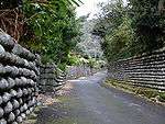 Tamaishigaki: Walls built by convicts exiled on Hachijō-jima in the Edo Period
 Karataki waterfall: The Karataki waterfall, in the hills around Mt. Mihara
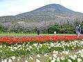 Freesia Festival: The annual freesia festival.
 Aloe growing on Mt. Hachijō-Fuji
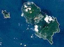
- Landsat image: Hachijō-jima and Hachijō-Koshima
 Hachijō-jima: Hachijō-jima View
 Hachijō-jima Kurosuna: View from the top of the rock at Kurosuna, Hachijō
See also
- Runin: Banished, a 2004 film about convicts exiled to Hachijōjima, and their attempts to escape.
- Battle Royale, a controversial 2000 film filmed on the neighbouring, uninhabited, Hachijō Kojima, although not set on the island.
- List of islands of Japan
Notes
- ↑ Nussbaum, Louis-Frédéric. (2005). "Izu Shotō," Japan Encyclopedia, p. 412; Ponsonby-Fane, Richard. (1962). Sovereign and Subject, p. 332.
- ↑ "Hachijojima Climate Normals 1961-1990". National Oceanic and Atmospheric Administration. Retrieved January 5, 2013.
- ↑ http://www.hachijo-h.metro.tokyo.jp/
References
- Teikoku's Complete Atlas of Japan, Teikoku-Shoin Co., Ltd. Tokyo 1990, ISBN 4-8071-0004-1
External links
![]() Media related to Hachijojima at Wikimedia Commons
Media related to Hachijojima at Wikimedia Commons
- Hachijojima - Japan Meteorological Agency (Japanese)
- "Hachijojima: National catalogue of the active volcanoes in Japan" (PDF). - Japan Meteorological Agency
- Hachijo Jima Volcano Group - Geological Survey of Japan
- Hachijojima: Global Volcanism Program - Smithsonian Institution