Haakon County, South Dakota
| Haakon County, South Dakota | |
|---|---|
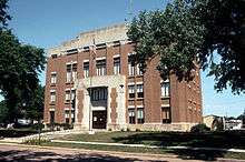 Haakon County Courthouse in Philip | |
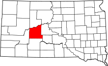 Location in the U.S. state of South Dakota | |
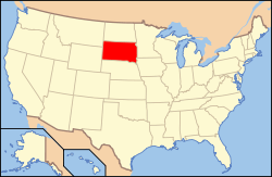 South Dakota's location in the U.S. | |
| Founded | 1915 |
| Named for | Haakon VII |
| Seat | Philip |
| Largest city | Philip |
| Area | |
| • Total | 1,827 sq mi (4,732 km2) |
| • Land | 1,811 sq mi (4,690 km2) |
| • Water | 16 sq mi (41 km2), 0.9% |
| Population (est.) | |
| • (2015) | 1,861 |
| • Density | 1.1/sq mi (0/km²) |
| Time zone | Mountain: UTC-7/-6 |
Haakon County is a county located in the U.S. state of South Dakota. As of the 2010 census, the population was 1,937.[1] Its county seat is Philip.[2]
History
The county was created in 1914 and organized in 1915,[3] and was formed from the original counties of Nowlin and most of Sterling, which had previously been absorbed by Stanley County. It is named for Haakon VII, who became king of Norway in 1905. It is the only county in South Dakota named for a non-American person and is one of only nine counties in South Dakota named for persons who did not live in South Dakota (Clay, Custer, Douglas, Grant, Hamlin, Lincoln, McPherson, and Meade are the other eight). Most of the 66 South Dakota counties are named for early South Dakota officials or legislators, or for physical features (Fall River and Lake), or are derived from Indian words (Minnehaha and Yankton), or from counties in other states (Jones and Walworth), with one (Aurora) named for a Roman goddess, one for an animal (Buffalo), and one (Union) for a concept.
Geography
According to the U.S. Census Bureau, the county has a total area of 1,827 square miles (4,730 km2), of which 1,811 square miles (4,690 km2) is land and 16 square miles (41 km2) (0.9%) is water.[4]
Major highways
 U.S. Highway 14
 South Dakota Highway 34
 South Dakota Highway 63
 South Dakota Highway 73
Adjacent counties
- Ziebach County, South Dakota - north
- Stanley County, South Dakota - east
- Jones County, South Dakota - southeast
- Jackson County, South Dakota - south
- Pennington County, South Dakota - west
Demographics
| Historical population | |||
|---|---|---|---|
| Census | Pop. | %± | |
| 1920 | 4,596 | — | |
| 1930 | 4,679 | 1.8% | |
| 1940 | 3,515 | −24.9% | |
| 1950 | 3,167 | −9.9% | |
| 1960 | 3,303 | 4.3% | |
| 1970 | 2,802 | −15.2% | |
| 1980 | 2,794 | −0.3% | |
| 1990 | 2,624 | −6.1% | |
| 2000 | 2,196 | −16.3% | |
| 2010 | 1,937 | −11.8% | |
| Est. 2015 | 1,861 | [5] | −3.9% |
| U.S. Decennial Census[6] 1790-1960[7] 1900-1990[8] 1990-2000[9] 2010-2015[1] | |||
2000 census
As of the census[10] of 2000, there were 2,196 people, 870 households, and 620 families residing in the county. The population density was 1 person per square mile (0,5/km²). There were 1,002 housing units at an average density of 1 per square mile (0/km²). The racial makeup of the county was 96.40% White, 2.50% Native American, 0.09% Asian, and 1.00% from two or more races. 0.59% of the population were Hispanic or Latino of any race.
There were 870 households out of which 32.60% had children under the age of 18 living with them, 63.60% were married couples living together, 4.80% had a female householder with no husband present, and 28.70% were non-families. 26.00% of all households were made up of individuals and 13.10% had someone living alone who was 65 years of age or older. The average household size was 2.47 and the average family size was 3.00.
In the county, the population was spread out with 25.70% under the age of 18, 7.00% from 18 to 24, 25.20% from 25 to 44, 24.10% from 45 to 64, and 18.00% who were 65 years of age or older. The median age was 41 years. For every 100 females there were 96.60 males. For every 100 females age 18 and over, there were 97.30 males.
The median income for a household in the county was $29,894, and the median income for a family was $35,958. Males had a median income of $25,098 versus $18,913 for females. The per capita income for the county was $16,780. About 12.00% of families and 13.90% of the population were below the poverty line, including 18.70% of those under age 18 and 16.00% of those age 65 or over.
2010 census
As of the 2010 United States Census, there were 1,937 people, 850 households, and 540 families residing in the county.[11] The population density was 1.1 inhabitants per square mile (0.42/km2). There were 1,013 housing units at an average density of 0.6 per square mile (0.23/km2).[12] The racial makeup of the county was 94.7% white, 1.9% American Indian, 0.4% Asian, 0.2% black or African American, 0.1% Pacific islander, 0.2% from other races, and 2.6% from two or more races. Those of Hispanic or Latino origin made up 0.9% of the population.[11] In terms of ancestry, 45.4% were German, 19.4% were Irish, 17.6% were Norwegian, 8.6% were English, 6.2% were Czech, 5.1% were Dutch, and 1.2% were American.[13]
Of the 850 households, 23.8% had children under the age of 18 living with them, 56.6% were married couples living together, 4.2% had a female householder with no husband present, 36.5% were non-families, and 33.2% of all households were made up of individuals. The average household size was 2.24 and the average family size was 2.86. The median age was 48.8 years.[11]
The median income for a household in the county was $46,281 and the median income for a family was $60,000. Males had a median income of $37,679 versus $22,277 for females. The per capita income for the county was $25,877. About 13.2% of families and 12.5% of the population were below the poverty line, including 14.9% of those under age 18 and 13.7% of those age 65 or over.[14]
Housing cost
In 2007, the average price (in US dollars) for housing was:[15]
- Single family home: $143,052
- Town homes and other attached homes: $116,019
- Twin homes: $176,744
- Mobile homes: $51,477
Communities
City
- Philip (county seat)
Town
Unincorporated communities
Unorganized territories
The county is divided into two areas of unorganized territory: East Haakon and West Haakon.
See also
References
- 1 2 "State & County QuickFacts". United States Census Bureau. Retrieved November 25, 2013.
- ↑ "Find a County". National Association of Counties. Retrieved 2011-06-07.
- ↑ "Dakota Territory, South Dakota, and North Dakota: Individual County Chronologies". Dakota Territory Atlas of Historical County Boundaries. The Newberry Library. 2006. Retrieved March 29, 2015.
- ↑ "2010 Census Gazetteer Files". United States Census Bureau. August 22, 2012. Retrieved March 26, 2015.
- ↑ "County Totals Dataset: Population, Population Change and Estimated Components of Population Change: April 1, 2010 to July 1, 2015". Retrieved July 2, 2016.
- ↑ "U.S. Decennial Census". United States Census Bureau. Retrieved March 26, 2015.
- ↑ "Historical Census Browser". University of Virginia Library. Retrieved March 26, 2015.
- ↑ Forstall, Richard L., ed. (March 27, 1995). "Population of Counties by Decennial Census: 1900 to 1990". United States Census Bureau. Retrieved March 26, 2015.
- ↑ "Census 2000 PHC-T-4. Ranking Tables for Counties: 1990 and 2000" (PDF). United States Census Bureau. April 2, 2001. Retrieved March 26, 2015.
- ↑ "American FactFinder". United States Census Bureau. Retrieved 2011-05-14.
- 1 2 3 "DP-1 Profile of General Population and Housing Characteristics: 2010 Demographic Profile Data". United States Census Bureau. Retrieved 2016-03-11.
- ↑ "Population, Housing Units, Area, and Density: 2010 - County". United States Census Bureau. Retrieved 2016-03-11.
- ↑ "DP02 SELECTED SOCIAL CHARACTERISTICS IN THE UNITED STATES – 2006-2010 American Community Survey 5-Year Estimates". United States Census Bureau. Retrieved 2016-03-11.
- ↑ "DP03 SELECTED ECONOMIC CHARACTERISTICS – 2006-2010 American Community Survey 5-Year Estimates". United States Census Bureau. Retrieved 2016-03-11.
- ↑ city-data.com
 |
Ziebach County | | ||
| Pennington County | |
Stanley County | ||
| ||||
| | ||||
| Jackson County | Jones County |
Municipalities and communities of Haakon County, South Dakota, United States | ||
|---|---|---|
| City | | |
| Town | ||
| Unincorporated communities | ||
| Indian reservation | ||
| Ghost towns | ||
| Footnotes | ‡This populated place also has portions in an adjacent county or counties | |
Coordinates: 44°18′N 101°32′W / 44.30°N 101.53°W