Haa Alif Atoll
| Thiladhunmathi Uthuruburi ތިލަދުންމަތީ އުތުރުބުރި | |
|---|---|
| Atoll | |
| Haa Alif Atoll | |
|
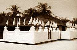
Utheemu Ganduvaru in Utheemu Island. | |
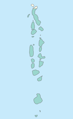 Haa Alif Atoll in Maldives. | |
| Country | Maldives |
| Capital | Dhidhdhoo |
| Geographic atolls |
2 atolls
|
| Government | |
| • Council | North Thiladhunmathi Atoll Council |
| Population (2006) | |
| • Total | 12,939 |
| Time zone | MST (UTC+05:00) |
| Assigned Letter | A |
| Assigned Letter (Dhivehi) | ހއ |
| Area code(s) | 650, 20 |
| ISO 3166 code | MV-07 |
| Inhabited | 14 - Baarah * Dhidhdhoo * Filladhoo * Hoarafushi * Ihavandhoo * Kelaa * Maarandhoo * Mulhadhoo * Muraidhoo * Thakandhoo * Thuraakunu * Uligamu * Utheemu * Vashafaru |
| Uninhabited | 29 - Alidhoo, Alidhuffarufinolhu, Beenaafushi, Berinmadhoo, Dhapparuhura, Dhigufaruhura, Dhonakulhi, Gaafushi, Gaamathikulhudhoo, Gallandhoo, Govvaafushi, Hathifushi, Huvahandhoo, Innafinolhu, Kandaalifinolhu, Kudafinolhu, Maafahi, Maafinolhu, Maarandhoofarufinolhu, Madulu, Manafaru, Matheerah, Medhafushi, Mulidhoo, Naridhoo, Umareifinolhu, Un'gulifinolhu, Van'gaaru, Velifinolhu |
| Total | 43 |
| Website | Haa Alif Atoll |
Haa Alif Atoll (also known as Northern Thiladhunmathi Atoll or Thiladhunmathi Uthuruburi) is the northernmost of the 19 administrative atolls of the Maldives.
Geographically, this atoll consists of Ihavandhippolhu, the northernmost geographical atoll of the Maldive archipelago, and the northern section of Thiladhunmathi atoll, which was administratively divided into northern and southern divisions in 1958. The atoll's official name, 'North Thiladhunmathi' is in reference to this division. Today, Haa Alif Atoll contains 43 islands, 14 of which are inhabited and classified as 'island-class' constituencies. Haa Alif Atoll is the third-largest atoll in the Maldives in terms of population and land area.
The capital of Haa Alif Atoll, and the location of the Secretariat of North Thiladhunmathi Atoll Council is the island of Dhidhdhoo.
History
In Matheerah there is a famous shrine (ziyaraiy, mausoleum) which was visited formerly by the Maldive kings and their families in order to seek blessings. Such tomb visits are aspects of Sufism that existed among the Maldivians until very recent times. Hence this island was referred to with the honorific title Matheerahffulhu (High (noble) Island) by the Sufi Muslims of the Maldives at that time.
Traditionally the northernmost atoll of the Maldives was Minicoy (Maliku). Fishermen from Thuraakunu and from Minicoy often crossed the Maliku Kandu on their boats to visit each other's islands. Marriage alliances were common. Now Minicoy is a part of India and communication is highly restricted.
Islands
Haa Alif Atoll contains 43 islands. 14 of them are inhabited, and are classified as administrative island constituencies. Each of these constituencies have an 'island council' which responds to the North Thiladhunmathi Atoll Council.
| Map |
|---|
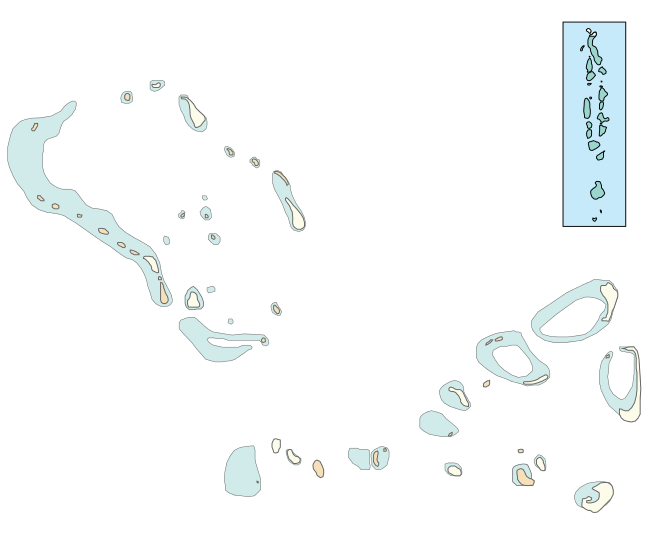 Alidhoo Alidhuffarufinolhu Beenaafushi Berinmadhoo Dhapparuhura Dhigufaruhura Dhonakulhi Gaafushi Gaamathikulhudhoo Gallandhoo Govvaafushi Hathifushi Huvahandhoo Innafinolhu Kandaalifinolhu Kudafinolhu Maafahi Maafinolhu Maarandhoofarufinolhu Madulu Manafaru Matheerah Medhafushi Mulidhoo Naridhoo Umareifinolhu Un'gulifinolhu Van'gaaru Velifinolhu |
Island constituencies
| Name | Population (2006) | Education | Health | Political ward | Remarks |
|---|---|---|---|---|---|
| Baarah | 1,203 | K-10 | 1 health centre | A03 Baarah | |
| Dhidhdhoo | 2,512 | K-11 | 1 hospital | A04 Dhidhdhoo | Capital of Atoll |
| Filladhoo | 548 | K-10 | 1 health centre | A05 Kelaa | |
| Hoarafushi | 2,204 | K-12 | 1 health centre | A01 Hoarafushi | |
| Ihavandhoo | 2,447 | K-12 | 1 health centre | A02 Ihavandhoo | |
| Kelaa | 1,200 | K-10 | 1 health centre | A05 Kelaa | |
| Maarandhoo | 530 | K-10 | 1 health centre | A02 Ihavandhoo | |
| Mulhadhoo | 172 | K-8 | 1 health provider | A02 Ihavandhoo | |
| Muraidhoo | 451 | K-10 | 1 health centre | A03 Baarah | |
| Thakandhoo | 340 | K-9 | 1 health centre | A03 Baarah | |
| Thuraakunu | 347 | K-10 | 1 health centre | A01 Hoarafushi | Northernmost island in the country. |
| Uligamu | 267 | K-10 | 1 health centre | A01 Hoarafushi | |
| Utheemu | 521 | K-10 | 1 health centre | A03 Baarah | Location of iconic Utheemu Ganduvaru. |
| Vashafaru | 471 | K-12 | 1 health centre | A05 Kelaa |
Uninhabited Islands
All uninhabited islands in Haa Alif Atoll are under the control of the North Thiladhunmathi Atoll Council.
Disappeared Islands
These are islands which during recorded history, have been completely eroded away, claimed by the sea due to the sea-level rise associated with global warming or assimilated by other islands.
- Gasthirifinolhu
- Gudhanfushi
- Huraa
- Nasfaru
- Thiladhoo (merged into Dhidhdhoo, it was after this island that the atoll got its name of 'Thiladhunmathi')
- Thinadhoo
Atoll Council
| North Thiladhunmathi Atoll Council | |
|---|---|
 | |
| Type | |
| Type | |
| Leadership | |
President |
Ahmed Rishwan, MDP |
| Seats | 10 |
| Meeting place | |
|
Secretariat of the North Thiladhunmathi Atoll Council, Shaariu’l Ameen, Dhidhdhoo | |
| Website | |
|
www | |
North Thiladhunmathi Atoll Council is the local government body responsible for the governance of the Haa Alif Atoll. The council was created in 2011, with the enactment of the Decentralization Bill, which saw the introduction of local governance to the country.
The atoll is divided up into 5 political wards each with two councillors.
Members
| Ward | Code | Name | First elected | Party |
|---|---|---|---|---|
| Hoarafushi | A01 | Abdul-Hannaan Ahmed Fulhu | 2011 | MDP |
| Hoarafushi | A01 | Ibrahim Rasheed | 2011 | MDP |
| Ihavandhoo | A02 | Mohamed Rasheed | 2011 | MDP |
| Ihavandhoo | A02 | Abdullah Hussain | 2011 | MDP |
| Baarah | A03 | Hussain Naseer | 2011 | DRP |
| Baarah | A03 | Hussain Rasheed | 2011 | DRP |
| Dhidhdhoo | A04 | Yoosuf Siraj | 2011 | MDP |
| Dhidhdhoo | A04 | Ahmed Rishwan | 2011 | MDP |
| Kelaa | A05 | Adam Thahzeem | 2011 | DRP |
| Kelaa | A05 | Mohamed Fayaz | 2011 | DRP |
References
- Divehi Tārīkhah Au Alikameh. Divehi Bahāi Tārikhah Khidmaiykurā Qaumī Markazu. Reprint 1958 edn. Malé 1990.
- Divehiraajjege Jōgrafīge Vanavaru. Muhammadu Ibrahim Lutfee. G.Sōsanī.
- Xavier Romero-Frias, The Maldive Islanders, A Study of the Popular Culture of an Ancient Ocean Kingdom. Barcelona 1999.
First-level administrative divisions of the Maldives | ||
|---|---|---|
| Atolls |  | |
| Cities | ||
Coordinates: 6°52′48″N 73°06′44″E / 6.88°N 73.112222°E