Hà Tiên
| Hà Tiên city Thành phố Hà Tiên | |
|---|---|
| City | |
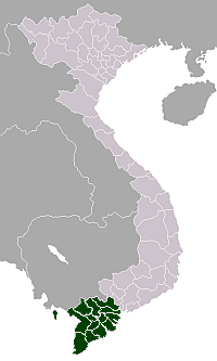
 Hà Tiên city Location in Vietnam | |
| Coordinates: 10°23′N 104°29′E / 10.383°N 104.483°E | |
| Country | Vietnam |
| Admin. division | Kiên Giang Province |
| Population (2002) | |
| • Total | 39,957 |
Hà Tiên is a district-level town in Kiên Giang Province, Mekong Delta of Vietnam. Area: 8,851.5 ha, population (2002): 39,957. The town borders Cambodia to the west.
Hà Tiên is a popular tourist site of the region thanks to its beautiful beaches and landscapes.
History

A settlement and a port seem to have existed at the site of the present town of Hà Tiên from a very early period. Ptolemy's Geography identified a town there as Akadra and that it was the port for the Cambodian district of Pithonobaste - Banteay Meas, all this being part of the Kingdom of Funan. The local capital of this district, also called Banteay Meas, was not on the coast, but located about a day's journey up the Giang-thành river. The name Banteay Meas, (Khmer: បន្ទាយមាស, Thai: บันทายมาศ; lit: "golden ramparts"), referred to the bamboo fortifications once used about the town. The town of Hà Tiên was originally known under the Khmer, name of Piem or Peam (Khmer: ព឵ម, Thai: เปียม, Chinese: 港口; also Pie, Pam, Bam), the Khmer for "port", "harbour" or "river mouth", while the Vietnamese called it Mang-Kham, from the Vietnamese term for the Khmers, "mang". It was through this port that Buddhism is said to have reached Cambodia, brought there by chance when a ship carrying Buddhaghosa was blown there by a storm in 415 AD. Buddhaghosa had with him the famous Emerald Buddha statue, for many centuries thereafter a state treasure of Cambodia and later Laos, until it was carried away by Thai invaders to be placed at its present location in the Wat Phra Kaew in Bangkok.[1]
Many works incorrectly referred to Hà-Tiên as “Panthaimas", the early name of the district in which it was located. It was variously spelled as Panday-mas (Khmer), Ponteamass (English), Phutthaimat (Thai: พุทไธมาศ) or Banthaimat (Thai: บันทายมาศ), Ponthiamas or Pontheaymas (French), Pontiano (Robert’s Map, 1751), Panthai-mas, Bantaimas, Pontiamas, Pontaimas, Bantay-mas, Banteay M’eas, Pontiamas, Pontiamasse, Po-taimat, and infinite other variations.[2]
Hà Tiên was established by a small group of Chinese people, mostly men who supported the Ming Dynasty and were opposed to the Qing Dynasty, led by Mo Jiu (Mạc Cửu). When they arrived in Đàng Trong (as southern Vietnam was called while under the rule of the Nguyễn lords), the Nguyễn lords ordered the king of Cambodia (then a vassal state of Đàng Trong) to grant land to these Chinese people. These people built markets in this place and turned it into a busy business town. Vietnamese people gradually arrived there. This town later was merged into Vietnamese territory when Mo Jiu delivered its sovereignty to the Nguyễn Lords. Mo Jiu was then conferred the position of ruler of this town. It was at this time that the name Hà Tiên (河仙 - "River Spirit"), referring to the guardian deity of the Giang-thành river, was conferred on the town by the Emperor Minh Vương.[3]
Economy
Ha Tien is the site of a large cement plant. (The cement plant is actually in Kien Luong,which is 22km south of Ha Tien)Its history goes back to the Republic of Vietnam (South Vietnam), where it was one of the largest industrial projects when construction was started in April 1961.[4]
Transportation
Buses connect Hà Tiên to the provincial capital Rạch Giá and many other towns in the Mekong Delta-including Châu Đốc,Can Tho,Ca Mau,Vung Tau and Saigon. A border crossing between Hà Tiên and Kampot in Cambodia was opened in 2007. The border is 7 km west of Hà Tiên.Opening hours here are 07.00 to 18.00
Daily fast ferries are available to Phú Quốc island.In the low (wet) season they normally operate twice a day-at approximately 08.00-08.30 and then 13.00-13.30 (Times vary a bit according to tides/weather etc)In the high season they run more frequently,with up to 3 fast boats(Superdong) each making up to 3 crossings every day.The trip takes about 80-90 minutesThere are also now(Sept 2016)4 car ferries operating from Ha Tien to the N/E corner of the island at Bai Thom.These run on demand,not to a fixed schedule,and can start as early as 05.00 and run until 21.00.This takes about 2.5 hours
Coordinates: 10°23′N 104°29′E / 10.383°N 104.483°E
References
- ↑ G. E. Gerini, “Notes on the Early Geography of Indo-China”, Journal of the Royal Asiatic Society of Great Britain & Ireland, 1897, p. 557; review of G. E. Gerini, Researches in Ptolemy's Geography of Eastern Asia (Further India and Indo-Malay Archipelago) (London, Royal Asiatic Society, 1909), in The Geographical Journal, vol. 37, no.1, January 1911, p. 82; Nicholas Sellers, The Princes of Hà-Tiên (1682-1867): the Last of the Philosopher-Princes and the Prelude to the French Conquest of Indochina: a Study of the Independent Rule of the Mac Dynasty in the Principality of Hà-Tiên, and the Establishment of the Empire of Vietnam, Brussels, Thanh-long, 1983, p. 9.
- ↑ Nicholas Sellers, The Princes of Hà-Tiên (1682-1867): the Last of the Philosopher-Princes and the Prelude to the French Conquest of Indochina: a Study of the Independent Rule of the Mac Dynasty in the Principality of Hà-Tiên, and the Establishment of the Empire of Vietnam, Brussels, Thanh-long, 1983, p. 164.
- ↑ Nicholas Sellers, The Princes of Hà-Tiên (1682-1867): the Last of the Philosopher-Princes and the Prelude to the French Conquest of Indochina: a Study of the Independent Rule of the Mac Dynasty in the Principality of Hà-Tiên, and the Establishment of the Empire of Vietnam, Brussels, Thanh-long, 1983, p. 24.
- ↑ Đặng Phong (2004), Kinh tế Miền Nam Việt nam thời kỳ 1955 - 1975, Nhà xuất bản Khoa học xã hội, Hanoi, page 286
External links
| Wikimedia Commons has media related to Ha Tien. |
 Hà Tiên travel guide from Wikivoyage