Gurnard's Head
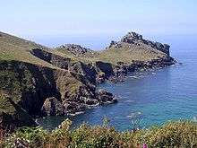

Gurnard's Head (Cornish: Ynyal, meaning desolate one) (grid reference SW432386) is a prominent headland on the north coast of the Penwith peninsula in Cornwall, England, United Kingdom.[1] The name is supposed to reflect the fact that the rocky peninsula resembles the head of the gurnard fish.[2]
Geography
It is near the hamlet of Treen in the parish of Zennor, one mile to the west of Zennor Head. Almost entirely owned by the National Trust, the headland is within the Aire Point to Carrick Du SSSI and the South West Coast Path crosses the southern part of the headland. The area is designated as part of the Penwith Heritage Coast and also designated as part of the Cornwall Area of Outstanding Natural Beauty. A pub and hotel on the coast road shares a name with the settlement.[3]
History

The headland is the site of an Iron Age promontory fort known as Trereen Dinas.[4] On the cliff-edge, above Treen Cove are the remains of Chapel Jane, which could have been a guild chapel of local fisherman. The earliest pottery dates to 1100 to 1150 AD, but the original simple structure of the chapel is comparable with the tiny chapels of St Helen's and Teän, in the Isles of Scilly, and an association with the adjoining stream which according to local, 19th-century, tradition was regarded as a holy well, could indicate an earlier, possibly 8th-century founding.[5]
To the east of the headland is an engine house belonging to a copper mine, originally known as Treen Copper Mine (before 1821) and later renamed Gurnard's Head Mine.[6]
In 1870 the Gurnard's Head seine fishery was worth an estimated £800 per year and employed twenty-four men with ten boats and two seines.[7] The pilchards (Sardina pilchardus) were sold locally as fresh pilchards rather than salted and sold as fumadoes for the Mediterranean market.[8] There are two small coves to the east of, and sheltered by Gurnard's Head; Treen Cove and Rose-an-Hale Cove.[9]
The headland was popular with tourists' during Queen Victoria's reign. The freehold of the Gurnard's Head Inn was put up for sale by auction on Thursday 27 May 1880, at the Western Hotel, Penzance. The Inn was part of the ′Nicholls' Tenement′ and there was also rights of common on Treen Cliff and 12 acres (4.9 ha) of ″fertile arable lands and improvable enclosed Crofts and Moors″.[10]
References
- ↑ OS Explorer Map 102 - Land's End (B2 ed.). Southampton: Ordnance Survey. 2010. ISBN 978 0 319 24116 5.
- ↑ Pool, Peter A S. The Place-Names of West Penwith (Second ed.). Heamoor: Self published. p. 89.
- ↑ "The Gurnard's Head". EATDRINKSLEEP. Retrieved 18 November 2016.
- ↑ Craig Weatherhill Cornovia: Ancient Sites of Cornwall & Scilly (Alison Hodge 1985; Halsgrove 1997, 2000)
- ↑ Charles Thomas (1974). Christian Sites in West Penwith Excursion Guide. Redruth: Institute of Cornish Studies. pp. 11–15. ISBN 0 903686 04 X.
- ↑ "Gurnards Head Mine". Pastscape. Historic England. Retrieved 25 November 2016.
- ↑ Anon (April 1872). "Spring Meeting 1871". Journal of the Institute of Cornwall. XIII.
- ↑ Anon (24 October 1878). "The Harvest of the Sea". The Cornishman (15). p. 4.
- ↑ 1:10,000 Sheet Gurnard's Head. Ordnance Survey.
- ↑ "Gurnard's Head, Zennor". The Cornishman (95). 6 May 1880. p. 1.
External links
- Trereen Dinas promontory fort site page on The Megalithic Portal
- Gurnard's Head cliff fort site page on The Modern Antiquarian
- The Gurnard's Head pub
Coordinates: 50°11′30″N 5°35′57″W / 50.19160°N 5.59922°W