Gulf of Taranto
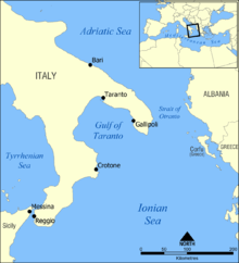
The Gulf of Taranto (Italian: Golfo di Taranto, Latin: Sinus Tarentinus) is a gulf of the Ionian Sea, in Southern Italy.
The Gulf of Taranto is almost square, 140 km long and wide, and is delimited by the capes Santa Locos di Leuca (east, Apulia) and Colonna (the ancient Cape Lacinium, west, in Calabria). It is surrounded by three Italian regions, Apulia, Basilicata, and Calabria. The most important rivers are the Basento, the Sinni, and the Agri.
The main cities on the gulf are Taranto and Gallipoli. Also the Greek colonies (Magna Graecia) of Croton, Heraclea, Thurii, and Sybaris were founded on the Gulf of Taranto.
Coordinates (Lat/Long):
- NW: N 41.00 / W 17.41
- NE: N 40.59 / E 15.51
- SW: N 39.58 / E 15.51
- SE: N 40.00 / W 17.41
Italy claims the whole gulf as national waters, thus closed to international traffic. This position, which is a similar position to Libya on the Gulf of Sidra, is not recognized by some other countries, such as the United States and the United Kingdom. [1]
References
- ↑ Hattendorf, John B. (2000). Naval Policy and Strategy in the Mediterranean: Past, Present, and Future. Frank Cass Publishers. p. 353.
Coordinates: 39°53′06″N 17°16′37″E / 39.88500°N 17.27694°E